Poor Victorian weekend; great open beaches all of next week

Victoria Surf Forecast by Ben Matson (issued Friday 27th May)
Best Days: Mon thru' Fri: offshore at open beaches all week. Building W'ly swells late Mon/Tues, but a solid long period swell is due later Wed, peaking Thurs, easing Fri. Thursday is the pick of the week at this stage.
Recap: Onshore winds kicked in mid-morning on Thursday but the Surf Coast didn’t see an appreciable increase in size until overnight (the Mornington Peninsula did however see a building trend in the afternoon with new W/SW swell). Today we’ve awoken to clean, but very inconsistent 3ft+ sets in Torquay and bigger but more wind affected surf east of Melbourne.
This weekend (Saturday 28th - Sunday 29th)
No major changes to the weekend - it’s generally a write-off across the Victorian coast.
I’m not expecting any major new swell, and winds are expected to strengthen from the SW as a broad low pressure centre becomes established east of Tasmania and the Far Southern NSW coast. Local winds have been pulled back a bit in the latest model runs but either way it’s not looking good for either coast.
There is a chance for a brief period of W’ly winds in Torquay both Saturday morning (before the onset of the SW flow) and also Sunday morning (as the SW flow starts to break down) but without any quality underlying swell there’s not much to look forward to.
And, in order to generate useful local windswell for the Surf Coast - west of Torquay - we ideally need a straight southerly, or south-east fetch through Bass Strait. With Saturday’s winds being more SW thru’ S/SW I just don’t think there’s enough potential for any notable size here.
So all in all, this weekend will be better spent doing other things away from the coast.
Next week (Monday 30th onwards)
A large high pressure system will migrate slowly across the region early next week, anchoring itself in the southern Tasman Sea as a blocking pattern and directing NE winds across the region from Monday thru’ Thursday at least, possibly into Friday.
So, this means we’ve got a whole week of great conditions for the open beaches, both east and west of Melbourne.
This blocking pattern will also keep the Southern Ocean storm track away from our region, which means surf quality should be quite good, though wave heights will be generally undersized (and best suited east of Melbourne), and set waves will be very inconsistent.
A conveyor belt of storms way our near Heard Island right now is generating several long period W’ly swells that’s due to arrive in several stages throughout Monday and Tuesday. At this stage no great size is likely due to the enormous travel distance - it’ll probably be too small for the Surf Coast, but very infrequent 3-4ft sets should start to appear across the Peninsula and Island’s open beaches (probably Tuesday more so than Monday, as the first of the two swells doesn't look very impressive). Expect breaks of up to 15 minutes or more between waves though.
A much more significant development of this same storm pattern is then expected to take place east of Heard Island around Monday, and this is expected to generate a big, more defined groundswell arriving later Wednesday and peaking through Thursday, even holding into Friday morning (though likely easing by this time). At the height of the swell on Thursday, we should see set waves pushing 6ft+ across open beaches east of Melbourne however it’s likely that the Surf Coast will only reach a very inconsistent 3ft owing to the westerly component in the swell direction.
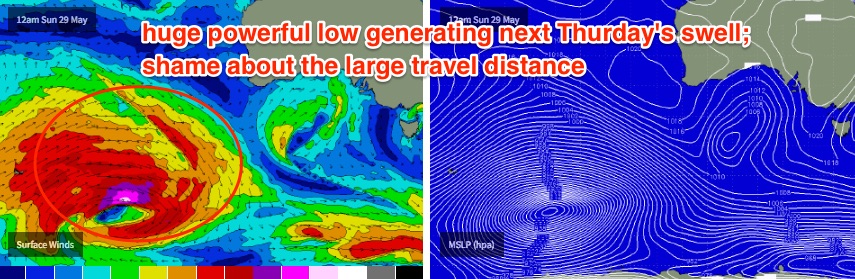
Again, expect very long breaks between the sets during this event too - between waves there’ll be lengthy periods of tiny to flat conditions, especially on the Surf Coast. But it’s a very impressive low pressure system and the swell quality should be quite high.
Looking into next weekend, and follow up fronts behind Monday’s impressive low should maintain plenty of moderate westerly swell through Saturday and Sunday. Craig will have more on that in Monday’s updated notes.
Until then have a great weekend!
Comments
Still plenty of clean waves in Torquay, shame the full tide is fattening it right up.
Ben last weekend was all time (east) will the coming week be as good?
Fun yes. All time?
The bank I was on was pretty bloody good and long. On a scale of 1-10 I would rate it an 8 for sure, particularly as the crowd was onto it. Mobile phones have a lot to answer for.
" Mobile phones have a lot to answer for. "
Guns don't kill people , People do .
Don't blame the Phone , blame the operator/s' .! So in that instance mobile phone / swellnet whats the difference .
Just from your post i would expect another dozen guys sniffing around your coast from Melbourne . Could be a long week . ;-)
Southey not sure if it is locals or note, but a lot of the youngish blokes see the bank and get on their phones to their mates. Before you know it the car park is full of utes. I am totally selfish I tell no one.
Doesn't matter if they are locals memla. If there was a waterproof device to allow it some of these clowns would take their phones into the water with them.
If memlas 1 post is gunna attract a dozen people, there's gunna be thousands down south next time it's on after your little outburst the other week!! Hah
Yeah sure goofy and the banks always last forever, and the wind never changes, and the tide is always the same. Each week is something different with beach breaks and I didn't name anywhere. It ain't reefs in case you didn't know.
Memla, relax mate.
I was replying to Southey
Only the worthy gf .
That area can take care of itself , the ocean tends to sort out those that aren't worthy .
If you think the reef / reefs are heavy the beaches pound for pound are another level .
;-)
Apologies Goofy. Bit sensitive, touchy subject, chip on shoulder? Yes all of the above.
Looks pretty bloody good at this stage!
Great the banks are cherry ripe.
Fun lumpy waves at 13th Beach, this looks 3-4ft or so.
That's really talking it up :D
Really;)
How does the blocking high pressure let the swell through. Doest it stuff the fetch? Very novice at this synoptic stuff but trying to learn :)
Just keeps the swell producing systems further away from the coast.
only been down here since Feb, but already liking it better than Illawarra
Get through your first winter then see how you feel. Haha
And historically winter doesn't start down here till July . That's when the water starts getting proper cold .
looked willy temp, says 11.2 but feels like 4.4 and that feels just about right at the moment.
Hey the automated forecasts are all point to Monday as being bigger that Tuesday .... assuming from the fading swell from this weekend, but you've said that it'll be smaller ? How big do you reckon Monday morning will be ?
Cheers
I think the models are holding some of the weekend's (short range windswell) size into Monday, and slightly under-representing the new long period groundswell due on Tuesday.
I'll take a look tomorrow once the models are updated but in any case there's no change to local conditions, and Tuesday should deliver some good waves east of Melbourne. Monday is at risk for an early morning wobble thanks to the weekend's onshores. Should be on the improve though.
Sweet thanks heaps have a good weekend