Looking great Friday, and good again from Sunday

Victoria Forecast by Craig Brokensha (issued Wednesday 30th March)
Best Days: Thursday afternoon Surf Coast, Friday both coasts, dawn Saturday protected spots Surf Coast, Sunday Surf Coast, Monday and Tuesday both coasts
Recap
Poor conditions the last couple of days with a moderate to fresh onshore wind and moderate sized swell yesterday, easing back slowly into today with weaker but persistent onshore breeze.
This week and weekend (Mar 31 – Apr 3)
Tomorrow morning is still due to be a low point with small and super clean 2ft waves on the Surf Coast along with an offshore NW wind, tending lighter and more variable from the W/NW into the afternoon. Portsea will be the best option on the Mornington Peninsula before winds swing more westerly, along with 3-4ft of swell.
Through the day a new mix of mid-period SW groundswell and later arriving long-period groundswell are due, with sets due to reach 2-3ft into the afternoon on the Surf Coast and 3-5ft on the Mornington Peninsula.
 Of much greater importance is Friday morning, with the long-period SW groundswell due to peak through the morning.
Satellite observations picked up the core 50kt winds around the low, and we should see inconsistent but strong 3-5ft sets on the Surf Coast early, with 6ft waves on the Mornington Peninsula and the odd bomb at swell magnets, easing through the day.
Winds are great but a little unfavourable from the N/NW early on the Surf Coast reefs, swinging more NW through the day. Locations east of Melbourne should see a straighter N'ly early.
The swell will drop through the day, and then we'll head into the weekend.
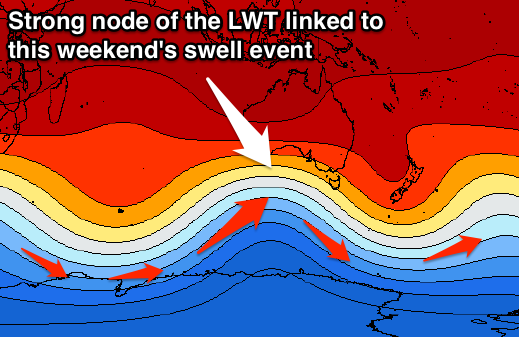
Currently a strong node of the Long Wave Trough is sitting just south-west of WA, and this node should move slowly east over the coming days before stalling and weakening slightly over Tassie through the weekend.
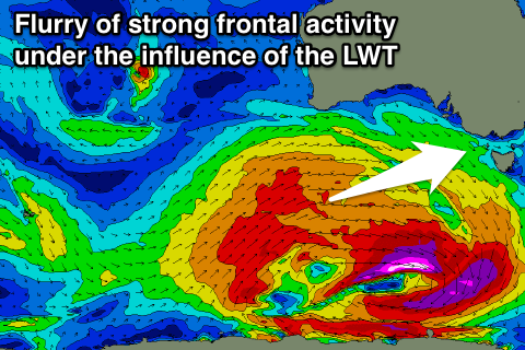
The Long Wave Trough steers and strengthens polar fronts up and just to the west of where it is positioned, and we'll see this occur over the coming days, with a vigorous polar front projected firstly up towards WA and towards the Bight, to then be overtaken by a secondary vigorous system projecting through the Bight and towards us Friday.
The second system will move over an already active sea state, with various pulses of large W/SW groundswell due, building through Saturday ahead of a peak Sunday morning.
 Size wise we should see the Surf Coast building from 3-4ft+ early to a strong 4-6ft into the late afternoon, peaking Sunday morning around 5-6ft. The Mornington Peninsula should build to 6-8ft and peak around 8ft+ Sunday morning.
Saturday's conditions aren't the best with an early W'ly breeze at dawn due to give way to a fresh and gusty SW change shortly there-after.
Sunday looks much better with light variable winds more than likely from the W/NW, before afternoon sea breezes kick in.
Next week onwards (Apr 4 onwards)
While the W/SW swell will ease back through Sunday afternoon, the easing trend will be slowed through early next week, but a moderate sized reinforcing SW swell from trailing polar frontal activity.
The Surf Coast should hang around 3-4ft+, with 6ft waves on the Mornington Peninsula, under local offshore winds.
Longer term easing surf and decent conditions are due through Tuesday and Wednesday, but more on this Friday.