Average weekend, better next week

Victoria Forecast by Craig Brokensha (issued Friday 18th March)
Best Days: Dawn Saturday Torquay for keen surfers, east of Melbourne Sunday through Tuesday, both coasts Wednesday morning, Surf Coast from Friday afternoon
Recap
Clean good fun waves across the Mornington Peninsula with an easing mix of swells from the 3ft+ range, while the Surf Coast was only offering 2ft sets.
Today an onshore change moved in around first light, creating poor conditions across all locations with no real size. A mix of windswell and groundswell are due to kick through the day, but tomorrow will be the best time to surf.
This weekend (Mar 19 - 20)
Today's onshore change is linked to the first of two fronts pushing through our swell window, with a second system moving up towards us through today and through around dawn tomorrow morning.
The strongest pulse of swell is due into the afternoon, with smaller 2-3ft waves due during the morning, kicking to a more consistent 3ft after lunch on the Surf Coast. The Mornington Peninsula should build to 4-6ft.
Unfortunately conditions are looking poor across most coasts as the front pushes through, creating fresh S/SW winds. The Torquay region is likely to see an early short-lived W'ly, but it's probably not worth the drive from Melbourne.
A drop in size is due through Sunday from 2-3ft and 4-5ft respectively with better E'ly winds on the Mornington Peninsula and across Phillip Island, while the Surf Coast looks to see less than ideal E/SE breezes.
Next week onwards (Mar 21 onwards)
Monday isn't looking too flash on the Surf Coast with small easing surf around 2ft on the sets along with an afternoon kick in E/SE windswell. The Mornington Peninsula will be the pick with easing 3ft to occasionally 4ft sets under a moderate to fresh E/NE breeze, giving in to sea breezes mid-late afternoon.
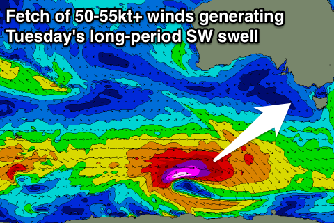 Tuesday's long-period SW groundswell is still on track, along with a slight upgrade in size. A vigorous polar low will now be longer-lived, with a fetch of severe-gale to storm-force W/SW winds being generated through our swell window all tomorrow and into Sunday morning.
The swell should arrive overnight Monday and peak Tuesday morning to a strong 3-4ft on the Surf Coast with larger sets at swell magnets, with 6ft to occasionally 8ft bombs on the Mornington Peninsula.
Winds will continue to be moderate to fresh from the E/NE, favouring locations east of Melbourne over the Surf Coast, with cleaner conditions due Wednesday morning as the swell fades steadily under local offshore breezes.
A low point in swell activity is due Thursday with local offshores, favouring the Mornington Peninsula ahead of some new groundswell energy into Friday and the weekend.
The models have come into alignment regarding the strength and track of a polar frontal progression firing up through next week and at this stage it's still looking good
A vigorous and slow moving polar low is on the cards, generating a moderate to large SW groundswell for Saturday, but more on this in Monday's update. Have a great weekend.