Clean easing surf, with a new swell for Saturday with early W'ly winds

Victoria Forecast by Craig Brokensha (issued Wednesday 15th March)
Best Days: Thursday morning, Saturday morning Surf Coast, Tuesday morning, Wednesday morning
Recap
The Surf Coast was a complete mess yesterday with a stormy mix of swells, building from the SE through the day to a solid 4-5ft into the afternoon. Winds were workable across the eastern end of the Mornington Peninsula and Phillip Island, providing peaky fun conditions for keen surfers.
Today both the SW and SE swell are easing under more favourable E/NE winds creating good clean conditions on the Mornington Peninsula and Phillip Island while the Surf Coast was better along the beaches.
This week and weekend (Mar 17 - 20)
Conditions will be much cleaner tomorrow with an offshore wind, and a small reinforcing SW swell will stop the easing trend temporarily. The Surf Coast should still provide 2ft sets with 3ft+ waves on the Mornington Peninsula with all day N'ly breezes expected.
Make the most of it, as Friday will be a lay day with tiny leftovers through the morning ahead of a gusty W/SW change.
This change will be linked to a couple of relatively weak cold fronts pushing in from the south-west over the coming days, generating two pulses of SW swell for later Friday and more so Saturday afternoon.
The strength of each system isn't the best with the Surf Coast due to come in at 3ft on Saturday, with the chance of the odd bigger set into the afternoon, while the Mornington Peninsula should see 5-6ft sets.
Conditions will be best early on the Surf Coast with a W/NW breeze, ahead of a S/SW change mid-late morning.
A drop in swell is then due through Sunday but conditions will remain average after Saturday's change with a SE-E/SE breeze across both coasts.
Next week onwards (Mar 21 onwards)
 A lingering SE'ly will continue to create average conditions Monday as the swell continues to ease, leaving no decent options.
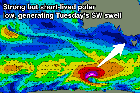
Tuesday is looking really fun as a good new long-period SW groundswell fills in, produced by a strong but short-lived polar low south-west of Tassie during the weekend. A burst of W'ly severe-gale to storm-force winds will be generated through our swell, with the swell peaking Tuesday morning to a good 3ft across the Surf Coast and 5ft+ on the Mornington Peninsula.
Offshore N/NE winds will favour the Mornington Peninsula and Surf Coast beaches, with fresher local offshores Wednesday as the swell eases.
Longer term we've got some stronger polar frontal activity due to develop through next week, but the models are still slightly divergent on the make-up off this setup, so check back here Friday for an idea on what's in store for the Easter Long Weekend.
Comments
Hey Craig,
The WAMS and a few other forecasts has a new swell filling in overnight/tomorrow morning. Do you think this is likely ?
Thanks
That swell doesn't have any size attached to it, and as the Surf Coast will be the only option (tiny), it's not worth the effort.
Gday Craig, is there a reason the water feals like its dropped a few degrees sinse sunday to mid week, (is this possible or am i just sooken it). Went for a paddle sunday and it still felt warm then had a splash yesters and it felt cold, then this morning dam freezen,
Yep I was definitely feeling it on the arms last night. This morning wasn't too bad I thought. Maybe from the Se winds we've had?
Yeah that would be some localised upwelling, like what we saw in Sydney. Strong cross-shore E/SE winds pushing the warm surface water away from the coast. https://www.swellnet.com/news/swellnet-analysis/2016/03/10/sydneys-cold-water-episode-explained
It's down to 17.8deg or so when it was around 20.
Tomorrow with the onshore change it should bring the warm water back in again for the weekend.
Vicco needs more onshores.
cheers mate appreciate the info