Easing surf with onshores, good new SW groundswells next week but with average conditions

Victoria Forecast by Craig Brokensha (issued Friday 4th March)
Best Days: Tuesday east of Melbourne, Wednesday morning both coasts
Recap
Tiny onshore start to yesterday, with a late increase in new W/SW swell which has peaked this morning to a good 3ft on the sets across the Surf Coast with light to moderate and workable onshore SW winds. The Mornington Peninsula and Phillip Island were cleaner with more variable tending light offshore winds and plenty of size.
The swell should ease a touch through the day as S/SE sea breezes develop.
This weekend (Mar 5 – 6)
Easing surf is expected most of the weekend on the backside of this morning's W/SW groundswell and winds are now looking average both Saturday and Sunday now.
Moderate to possibly fresh onshore S/SE winds are due tomorrow as the surf eases from 2ft+ on the Surf Coast and 4ft+ on the Mornington Peninsula, with similar strength winds from the SE Sunday. Tiny leftover 1-1.5ft waves are due on the Surf Coast with 3ft sets on the Mornington Peninsula, with a possible late increase in new SW groundswell due Monday (discussed below)
Next week onwards (Mar 7 onwards)
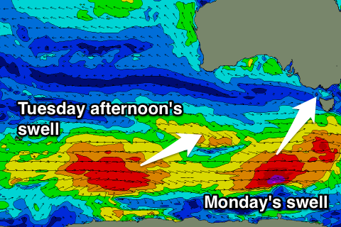 As touched on last update, new pulses of long-period and fun sized SW groundswell are due from Monday next week through the middle of the week, the biggest peaking Tuesday afternoon.
These swells will be generated by a series of strong polar fronts firing up along the polar shelf, with the structure changing a little since Wednesday.
Firstly a polar front currently dead south of WA will strengthen through today, aiming a fetch of gale to severe-gale W'ly winds through our south-western swell window as it races east and then under Tasmania tomorrow afternoon.
This swell may be seen late Sunday ahead of a peak Monday to a good 3ft on the Surf Coast and 4-5ft+ on the Mornington Peninsula.
A secondary broader, longer-lived and slower moving fetch of polar gales will move through our swell window over the weekend, and this is expected to produce another good pulse of SW groundswell for Tuesday, building towards a peak into the afternoon.
The Surf Coast should build to 3-4ft, with the odd bigger bomb likely at swell magnets, with 5-6ft+ waves across the Mornington Peninsula. A slow drop in size is then expected Wednesday from 3-4ft and 5-6ft respectively.
The favourable wind outlook has deteriorated unfortunately with onshore and fresh SE winds Monday and then E/NE winds Tuesday morning favouring the Mornington Peninsula. More variable winds may be seen Wednesday morning, but we'll review this Monday. Have a great weekend!
Comments
Hey Craig,
Any thoughts on long weekend, how's is looking haven't been able to go since summer holidays so very keen to go down.
Cheers mate
No mate sorry, that's ages away still.
Hey victoria surfing 1. Not being a smart ass and all but. Check the wams available above. See what's happening around the long wkend with swell height and wind direction. See what you come up with and compare with what actually happens. Simple, fun. I'm no pro like craig is but my guess would be roughly 3/6 ft east of the bay and 2/3 west of the bay. With generally NE winds . With a subject to change clause thrown in to. The