Poor conditions until Sunday

Victoria Forecast by Craig Brokensha (issued Wednesday 13th January)
Best Days: Sunday morning east of Melbourne, Monday morning both coasts, Tuesday morning east of Melbourne
Recap
Small onshore waves yesterday, while a late kick in new SW groundswell was seen, with it easing back today from 2-3ft on the Surf Coast (best on the beaches) and 4-5ft on the Mornington Peninsula.
This morning's offshore winds (east of Melbourne) should persist until the early afternoon before sea breezes try and kick in, fighting with an approaching change possibly resulting in variable winds. So keep an eye on local observations.
This week and weekend (Jan 12 - 17)
The coming few days aren't looking too flash at all with a strong SW change due to move through the early hours, creating poor conditions with small amounts of leftover swell during the morning.
The change will be linked to a strong mid-latitude low moving in from the west, generating a fetch of SW gales through our swell window, kicking up a late increase in new SW swell.
The size from this low has been downgraded a touch, but we should still see 3-4ft sets on the Surf Coast and 6ft to occasionally 8ft waves on the Mornington Peninsula Friday morning but with fresh and gusty S'ly winds.
Onshore winds should ease into Saturday but remain moderate from the SE, creating average conditions as the swell eases back steadily from 2ft+ and the 4ft range respectively.
 Sunday morning will finally see winds swing back to the NE creating clean conditions on the Mornington Peninsula but there isn't due to be much size with 2ft to possibly 3ft sets early.
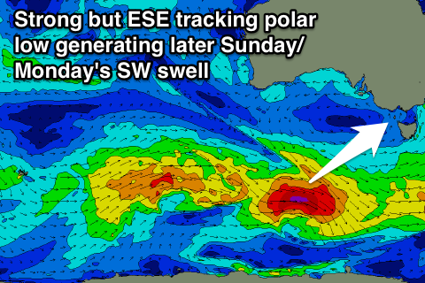
During the day though a strong kick in new SW groundswell is due, from an unfavourably east-southeast tracking but strong polar front/low combo on Friday.
The Surf Coast should kick to 2-3ft later in the afternoon as fresh E/SE sea breezes kick in, with 4-5ft sets on the Mornington Peninsula, easing back from a similar size Monday morning with N/NE offshores (possibly tending N/NW on the Surf Coast through the morning).
Next week onwards (Jan 18 onwards)
Unfortunately our good pulse of SW groundswell expected off a strong polar frontal progression mid-next week has been derailed somewhat, with a separate mid-latitude low and weaker polar front now due to form early next week.
In saying this both systems are expected to near us mid-late next week bringing another stormy increase in W/SW and SW swell, but we'll have a closer look at this on Friday.
Comments
Hey Craig
Is it reasonable to assume we'll see early NE'ers right across the state early Sunday, not just Mornington Peninsular?
Thanks
Some locations could be more E/NE, than NE.
that'll do!
thanks heaps
No worries.
And it looks like that approaching change has fought off the sea breeze, with light variable/offshore winds across most locations this afternoon in Bass Strait.
Actually looks like a 20-30kt offshore has hit the Surf Coast, insane!