Fun weekend, plenty of swell next week but onshore

Victoria Forecast by Craig Brokensha (issued Friday 18th September)
Best Days: Saturday both coasts (Surf Coast beaches), Sunday both coasts, early Monday Surf Coast and protected spots east of Melbourne for keen surfers
Recap
Good clean SW groundswell yesterday morning on the Surf Coast to 3-4ft with larger bumpier 6ft+ waves on the Mornington Peninsula.
A reinforcing SW swell for today has kept the surf up around a similar size today with the Surf Coast offering the best conditions again.
This weekend and next week (Sep 19 – 25)
Today's reinforcing SW groundswell will hold into tomorrow keeping good 3ft sets hitting the Surf Coast and 6ft waves on the Mornington Peninsula, easing back into Sunday as a new W/SW groundswell fills in. This should keep the Surf Coast around 2-3ft, with 5-6ft sets on the Mornington Peninsula.
Winds tomorrow will be best for locations east of Melbourne and the beaches on the Surf Coast with a light N/NE offshore ahead of weak SE sea breezes and then local offshore tending variable breezes Sunday.
Monday will be smaller with OK winds for both coasts at dawn, strong from the N/NW ahead of a SW change during the afternoon.
This change will spoil a new very inconsistent long-range W/SW groundswell arriving later in the day, with Tuesday also looking to be a write-off as a secondary S'ly change pushes through and a stronger SW groundswell moves in.
The long-range W/SW groundswell will only build to an infrequent 3ft+ to possibly 4ft on dark on the Surf Coast and 6-8ft on the Mornington Peninsula, holding into Tuesday morning.
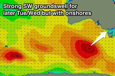 The secondary larger SW groundswell for later Tuesday will be generated by a vigorous polar low firing up in the Heard Island region today, projecting a fetch of severe-gale to storm-force W/SW winds under the country through this weekend.
The swell is only due to arrive later Tuesday, kicking to 4-5ft on the Surf Coast and 8ft on the Mornington Peninsula, easing from 3-5ft and 6-8ft respectively Wednesay morning.
Winds will remain poor though and fresh to strong from the S'th Wednesday and Thursday limiting options severely across the whole state.
It won't be until Friday that we see winds swing more E'ly favouring protected spots on the Mornington Peninsula with moderate pulses of SW groundswell from frontal activity swinging in from the Indian Ocean again. Next weekend winds look better, but check back here Monday for the latest on this.
Have a great weekend!
Comments
Hey Craig,
So is Monday going to be offshore (NW in the morning) around jan juc ? So the reefs should be pretty clean and is it going SW at like 1 or later in the afternoon ? Cheers
Dawn yes, but models diverge on the timing of the change.
European version has the change in around 8-9am, while the American version delays it more to late morning/midday.
With that in mind, earlier the better.
Hey Craig. Do you really think it will be offshore on Thursday? Everything I'm looking at says its going to be onshore.
No he's lying
No I don't think he's lying. I trust Craig to do an honest forecast. I think in this case its an honest mistake. He just needs to practise the art more. When it comes to surf forecasting, I believe the only thing that matters is experience. Something Craig is lacking, but there's no reason why he can't improve with more practise. Good on ya Craig. Hang in there buddy.
Pete_MELB what are you talking about. You said in your first comment "Hey Craig. Do you really think it will be offshore on Thursday? Everything I'm looking at says its going to be onshore" .But in the forecast notes Craig said " Winds will remain poor though and fresh to strong from the S'th Wednesday and Thursday limiting options severely across the whole state." So Craig is saying it will be onshore on Thursday and your trying to say he was saying it would be offshore.
Think you might need to just look in the mirror and have a good look at yourself Pete because you truly are a potato. Don't write a paragraph about how Craig is inexperienced and how he needs to practice the art more when you can't simply read his forecast notes properly you spud. Go back to school and learn to read
Craig your a jet mate don't listen to this potato doesn't no anything, your forecast notes are awesome
My surf couch says I need to practise my airs more. He tells me many times that offshore winds are poor for airs. Poor winds = offshore.
Hey craig,
Which direction is the change coming in on Monday ? For example, if one was to head southwest would it be hitting before dawn? Also, will the change gradually change from N->NW->W or will it just kick and ruin the party immediately?
Thanks, hope Jan Juc pumps sorrento tubbaazzz
Do yourself a favour and check bom.gov.au here your will find Craig's government pals and all their wisdom. After all they are the government...They also have a way bigger crystal ball than Craig and should be able to answer your questions. It's what we pay tax for!
Bit confused though craig,
Why does the "surf forecast " have it still being Westerly winds at midday in Monday do you reckon there's a chance it might hold of till the afternoon instead of mid-morning ?
Beause our model uses the American GFS version, and the other European version is the one pushing the change through earlier.
Looks to be arriving later now, late morning/midday.
Yeah superfish going down by v line then the bus to jan juc so hoping the winds hold off till afternoon on Monday
Plops the bom on the Geelong forecast gives a pretty vague answer just says what's the winds are and then if they will change direction doesn't tell you when though unless I am missing something would love a link to the winds for BOM
@Sorrento have a look here:
http://www.bom.gov.au/jsp/watl/wind/index.jsp
You can play with the area and the time/days and should give you an idea what's happening. Hope that's what you're looking for
and here: http://www.bom.gov.au/australia/meteye/
Thanks uncle Leroy and Dennisroethig much appreciated :)