Fun beachy options until an onshore change Thursday

Victoria Forecast by Craig Brokensha (issued Monday 31st August)
Best Days: Tuesday and Wednesday east of Melbourne, Saturday morning Surf Coast, Monday onwards Surf Coast
Recap
Terrible conditions all weekend with plenty of swell but onshore winds.
This morning an inconsistent long-range SW groundswell has kept strong 3ft sets hitting the Surf Coast with bigger waves to the east under light variable winds, creating better conditions across both regions. The swell should ease through the day as winds tend weak S/SE.
This week and weekend (Sep 1 - 6)
The coming days will be best east of Melbourne with easing amounts of long-range SW groundswell and light N/NE winds ahead of weak SE sea breezes. The Surf Coast is due to ease from a slow 2ft, with infrequent 3-4ft sets on the Mornington Peninsula.
Wednesday will be smaller with a moderate N/NE tending NE breeze, perfect for the Mornington Peninsula.
The rest of the week will be poor with tiny leftover amounts of swell Thursday morning and a strengthening S'ly breeze around 7am as a surface trough drifts in from the west, persisting from the S/SW through Friday.
As touched on last Friday, a very inconsistent long-range SW groundswell due for Saturday is still on track, with a strong but distant polar low firing up in the Heard Island region last night.
A fetch of severe-gale W/SW winds are being generated, but the storm will weaken before moving east of a line drawn south of WA, resulting in a lot of loss in size and consistency.
A better and more consistent SW swell will over-ride this swell, generated by a front swinging in from under WA towards Tassie through the middle to end of the week.
No major size is due with Saturday seeing 2-3ft sets on the Surf Coast during the morning and 4-5ft+ waves on the Mornington Peninsula, easing into the afternoon and further Sunday.
Morning NW-W/NW winds will favour the Surf Coast both Saturday and Sunday.
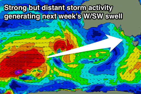 Longer term, some better long-range W/SW groundswell energy is due through early next week as a stronger and broader progression of polar fronts fire up in the south-east Indian Ocean and pushes a little closer to us.
At this stage we're probably looking at an inconsistent 3-4ft of swell on the Surf Coast later Monday/Tuesday and 6ft to occasionally 8ft on the Mornington Peninsula with westerly winds. We'll have a closer look at this Wednesday though.