Fun weekend, tricky west swells next week

Victoria Forecast by Craig Brokensha (issued Friday 7th August)
Best Days: Saturday Surf Coast, Sunday east of Melbourne, later Monday and Tuesday morning Surf Coast
Recap
Good and solid easing SW swell from 4-6ft yesterday with morning W/NW winds favouring the protected reefs, with larger average 8ft waves across the Mornington Peninsula. This morning winds were good around Torquay again the a dropping swell from 3-4ft.
This weekend (Aug 8 - 9)
The weekend's looking fun for both coasts, with smaller amounts of swell tomorrow, coming in at 2ft to occasionally 3ft across the Surf Coast and 4ft to occasionally 6ft on the Mornington Peninsula, dropping back from 2ft and 3-5ft respectively Sunday morning.
The Surf Coast will be cleanest tomorrow with a light variable tending offshore wind during the morning. Variable winds also on the Mornington Peninsula will see cleaner conditions than past days, but lumpy and improving conditions.
Sunday looks best east of Melbourne with N/NE tending N'ly breezes, (N/NW tending N'ly breezes on the Mornington Peninsula.
Next week onwards (Aug 10 onwards)
 Monday is still due to start tiny, with a new long-range and inconsistent SW groundswell due into the afternoon. This is being generated in our far swell window in the southern Indian Ocean, but should build to a very infrequent 2-3ft on the sets across the Surf Coast later in the day, with 5-6ft sets on the Mornington Peninsula under fresh N/NW tending NW winds.
The short-range W/SW swell due to also be in the mix Monday has been dropped, as the front moving in from the west generating this now due to form into a cut-off low in the Bight Sunday before moving across us Monday evening.
This should generate some W/SW swell for Tuesday to 3ft or so on the Surf Coast and 6ft on the Mornington Peninsula, easing with the long-range SW groundswell during the day as fresh to strong NW winds tend N/NW through the day.
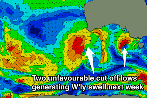
Unfortunately the stronger frontal activity due to push through our western swell window early to mid-next week is now also forecast to take the form of a cut-off which will limit the swell potential and also give it a less favourable W'ly bias.
The swell looks to peak through Thursday but only around 2-3ft on the Surf Coast and 5-6ft on the Mornington Peninsula, but we'll have to review this on Monday. Winds are also a little hard to pin down, so check back Monday for an update on all of this.
Have a great weekend!
Comments
Do you reckon the reefs around jan juc be working tommorow craigo?
Small wave reefs should have a coupla.
Hey Craig, just in regards to the dropping swell, it's only 3-4 here already here on morn peninsula. Gonna be tiny come Sunday?
P.s not having a dig at forecast either. I love my mon wed fri forecaster notes!!!
There's a couple of reinforcing and inconsistent groundswells due over the weekend. Hopefully at least 3-4ft Sunday morning.
Tiny across most of the Vicco coast this morning, almost flat. But managed to spot this lil' one foot peak at 13th Beach this morning.