Excellent swells on the way

Victoria Forecast by Craig Brokensha (issued Wednesday 27th May)
Best Days: Thursday both coasts (morning east of Melbourne), Surf Coast Friday through Sunday
Recap
The surf remained small and fun across the Surf Coast yesterday with clean glassy 1-2ft waves best suited to the beaches, while the Mornington Peninsula offered 3ft sets.
Today a new long-range and very inconsistent W/SW groundswell has started to fill in, coming in a little slow at dawn but now offering good 2ft to occasionally 3ft sets across exposed breaks on the Surf Coast and 5ft surf on the Mornington Peninsula under local offshore breezes. The swell should hold all day as winds remain favourable.
This week and weekend (May 28 – 31)
Into tomorrow, today's infrequent W/SW groundswell will replaced by a similar sized and much more consistent W/SW swell, generated by a vigorous frontal progression currently moving through the Bight and south-west of WA. A pre-frontal fetch of gale to severe-gale W/NW winds should produce a fun W/SW swell to 2-3ft on the Surf Coast and 4-5ft on the Mornington Peninsula, building a touch further in size and strength through the afternoon.
Winds will continue to be favourable for both coasts through the morning, with a fresh to strong N'ly early on the Mornington Peninsula, tending N/NW through the day, while the Surf Coast should see N/NW tending NW breezes.
Of much greater importance is the large and powerful W/SW groundswell due to fill in Friday across the state.
This is being generated by frontal progression currently passing under the country, with satellite observations already recording severe-gale to storm-force winds aimed towards us.
This progression is still generating a fetch of severe-gale W/SW winds through our western swell window but will weaken through tomorrow while approaching us, leaving a strong and large W/SW groundswell to propagate towards us.
The swell is due to arrive through Friday morning and kick very strongly during the day, peaking through the afternoon.
 The Surf Coast should build from 4-6ft early to 6-8ft with 10ft+ waves developing on the Mornington Peninsula.
Winds will be best for locations west of Melbourne with a fresh to strong NW tending W/NW wind, creating excellent conditions on the reefs.
A drop in size is due into the weekend, but this will be slowed by a reinforcing SW pulse, generated at polar latitudes on the backside of the low by a fetch of severe-gale SW winds.
The Surf Coast should ease from 5-6ft with 8ft sets on the Mornington Peninsula, down to 3-5ft and 6-8ft respectively through the afternoon. Conditions will remain good for locations west of Melbourne with a fresh to strong N/NW tending NW breeze.
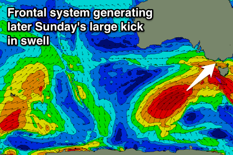
Into Sunday two new pulses of swell are due. The first being a fun sized W/SW groundswell for dawn, generated by a pre-frontal fetch of W/NW gales moving in under the Bight through Friday and early Saturday. This should kick the Surf Coast back to 4-6ft Sunday morning with 8ft sets on the Mornington Peninsula ahead of a larger and stronger SW groundswell through the afternoon and evening.
The polar front being projected up and into us, responsible for this swell has been upgraded in intensity since Monday, with a fetch of severe-gale SW winds now due to produce a large and powerful SW groundswell event.
The Surf Coast should reach 6-8ft again late afternoon with 10ft sets on the Mornington Peninsula, but winds will swing from a strong morning NW breeze, to the W/NW through the afternoon ahead of a late and strong SW change. There should be a window though where the swell builds through Sunday afternoon, before the wind changes on the Surf Coast.
Next week onwards (Jun 1 onwards)
Sunday afternoon's large kick in SW groundswell is due to ease into Monday and conditions look poor with a fresh to strong S/SW'ly, and only a very slim chance of an early W'ly at dawn around Torquay.
Into next week there's nothing too major on the cards at all until later in the week when some long-range W/SW groundswell is due. More on this Friday though.