Onshore until Saturday morning, good Monday and Tuesday

Victoria Forecast by Craig Brokensha (issued Wednesday 8th April)
Best Days: Saturday morning both coasts, Monday morning both coasts, Tuesday both coasts
Recap
Poor and deteriorating conditions with a strengthening onshore change yesterday with plenty of SW groundswell and building windswell.
Today the winds have backed off a touch but remained fresh from the S'th with 3-4ft of swell on the Surf Coast and larger but junkier surf to the east. A new SW groundswell is due this afternoon, building to 3-5ft and 6ft to occasionally 8ft respectively but with no quality.
This week and weekend (Apr 9 - 12)
This afternoon's increase in strong SW groundswell should start to ease through tomorrow from 3-4ft on the Surf Coast (odd bigger set likely at Bells at dawn) and the 6ft range on the Mornington Peninsula. Conditions will improve but remain average with a lighter onshore S'ly breeze due across both coasts, swinging S/SE into the afternoon. There's a slim chance for an early W'ly wind around Torquay, but in any case the final day of the Rip Curl Pro should be run.
Friday should become smaller but hang around 3ft across the Surf Coast and 4-6ft on the Mornington Peninsula as a reinforcing SW groundswell steadies the easing trend and winds will increase a touch from the S/SE and be more moderate to fresh rather than light to moderate.
Saturday morning will be the best time to surf over the weekend, and only across the Surf Coast. Friday's reinforcing SW swell is due to ease from 2-3ft and conditions will be clean with a light variable breeze that will likely tend W/NW through the morning. The Mornington Peninsula should be cleaner with the variable breeze and easing from a lumpy/wobbly 4-5ft.
A fresh onshore S'ly breeze is due into the afternoon though, with S/SW winds through Sunday as the swell bottoms out early morning.
A fun new S/SW groundswell is due to fill in Sunday afternoon, generated by a strong polar front firing up south-west of us through the coming days.
An inconsistent but good S/SW groundswell should develop off this system building to 2-3ft across the Surf Coast into the afternoon and 4-5ft on the Mornington Peninsula but with poor and fresh S/SW winds.
 Next week onwards (Apr 13 onwards)
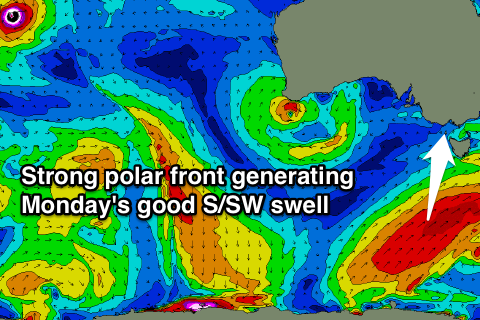
Of greater importance in regards to swell is the development of a much strong polar front on the tail of the low generating Sunday afternoon's increase. A strong node (peak) of the Long Wave Trough is forecast to move slowly across the southern Tasman Sea over the weekend, directing a vigorous polar front up through our southern swell window.
A fetch of severe-gale S/SW winds will be produced, generating a strong S/SW groundswell for Monday that's expected to peak at 3-5ft across the Surf Coast and 6ft+ on the Mornington Peninsula. Winds are looking dicey still with a light onshore S/SE breeze, but this will likely be variable at dawn creating clean workable conditions.
The swell will then ease quickly through Tuesday and bottom out Wednesday and Thursday under better N'ly and then NW winds. More on this Friday though.
Comments
Hi Craig,
So will Saturday be worth coming down from Melbourne will it be offshore the whole morning
Looking clean until around 11am at least so yes.