Good Saturday, fun next Wednesday

Victoria Forecast by Craig Brokensha (issued Friday 13th March)
Best Days: Saturday morning east of Melbourne, most of the day to the west, Monday morning east of Melbourne, Tuesday exposed breaks, Wednesday morning both coasts
Recap
Plenty of swell yesterday but with poor onshore SW winds, while today was similar as fresh S/SE winds continued to create poor conditions.
This weekend and next week (Mar 14 - 20)
Tomorrow is looking good across both coasts with a dropping swell from around 3ft on the sets across the Surf Coast and 6ft on the sets across the Mornington Peninsula beaches, but you'll have to get out early for the cleanest conditions east of Melbourne. At dawn a N/NE'ly is expected but this will swing N/NW through the mid-late morning and more W/NW into the afternoon.
This will favour the Surf Coast with clean conditions for most of the day ahead of a late SW change.
 With this change a better pulse of short-range S/SW swell is now due into Sunday but conditions will be poor with a fresh and gusty S/SE breeze.
Monday is looking better east of Melbourne with with a drop in S/SW swell from the 2ft+ range across the Surf Coast and 3-4ft+ on the Mornington Peninsula under morning E/NE winds.
Tuesday will be cleaner and straighter but with no real decent size with exposed breaks the only option under a N/NE'ly.
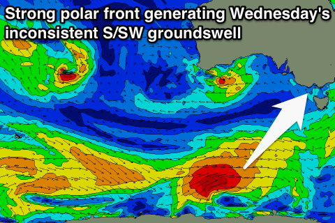
Our good pulse of S/SW groundswell due for Wednesday is still on track, and the power has been increased with the two weak polar fronts due to generate it now combining to one stronger and more consolidated system.
We should see a fetch of gale to severe-gale W/SW winds generated in our far swell window, producing an inconsistent but good S/SW groundswell for Wednesday.
The Surf Coast should offer good but inconsistent 3ft sets (but mainly be around the 2-3ft range) with 4-6ft sets on the Mornington Peninsula.
Winds are looking to be favourable at this early stage and from the N'th tending NW, but we'll review this on Monday.
Longer term a vigorous mid-latitude front is expected to push in from under WA and through the Bight towards us later in the week and with this we should see at least a medium sized W/SW groundswell generated for Friday/Saturday. The models are still moving around regarding this system though, but check back here on Monday for the latest on this. Have a great weekend!
Comments
Hi Craig,
Just wondering if you able to tell yet if there are any signs of big swells coming to Victoria for the 2 week holiday period coming up