Best options east of Melbourne

Victorian Surf Forecast by Ben Matson (issued Wednesday 4th February)
Best Days: Thurs/Fri/Sat: small waves east of Melbourne. Next week and beyond: extended period of small/moderate swells that should be just enough to get the Surf Coast running (but only just).
Recap: Poor surf thanks to persistent onshore winds.
This week (Feb 3 - 6)
We’re seeing building size and periods at the Cape Sorell buoy today, which has originated from a front tracking through the eastern periphery of our swell window on Tuesday. Most beaches will see an increase this afternoon (if you can discern anything beneath the windswell), and it should hold into Thursday morning with 3-4ft waves east of Melbourne and 2ft+ surf in Torquay (a slightly narrower size range between coasts than usual, due to the extra south in the swell direction).
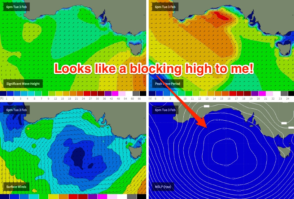
Nevertheless, the Surf Coast will be a write-off as winds swing to the east thanks to an eastward-migrating high pressure system that's been in a gnarly blocking pattern for the last few days (see image below). This will certainly focus the best surf towards the exposed beaches of the Mornington Peninsula and Phillip Island, mainly the southern ends.
Friday will see similar, if not marginally better conditions east of Melbourne as winds tend more E/NE through the morning (opening up the northern ends), but wave heights will ease steadily during the day so aim for the early session for the best surf. Expect very small, wind affected surf in Torquay.
This weekend (Feb 7 - 9)
As mentioned on Monday, we’ll have a window of light winds this weekend as the region falls between migrating high pressure systems. This means good conditions Saturday but average tending poor conditions on Sunday as winds restrengthen from the south.
Unfortunately, wave heights are expected to be mainly small both days.
We will see some small long period energy building throughout Saturday, as detailed in Monday’s notes, originating from a complex merger of several weather systems in the Southern Indian Ocean over the last few days: Severe Tropical Cyclone Eunice, Tropical Storm Diamondra, and also a strong polar low at similar longitudes, the latter of which will essentially sweep up the two tropical systems into the low latitude westerly flow.
Of all of these systems, the polar low has the most swell generating potential, but being positioned well SW of West Oz means that the large travel distance will significantly impact swell heights in Victoria.
Current model guidance expects the swell to peak on Sunday, which is a shame (due to the onshore) so Saturday afternoon is probably your best chance for the best combo of size and winds as the swell will slowly build all day. We should see 2-3ft+ sets across the open beaches east of Melbourne through the afternoon (smaller earlier) but expect long periods of flat conditions between waves. West of Melbourne, expect very small, slow surf all day best suited to beginners. Sunday will be a little bigger but less inviting due to freshening southerly winds.
Next week (Feb 10 onwards)
The weather charts are looking better for the long term, with several frontal progressions expected to develop from this weekend onwards. This is expected to supply moderate groundswell for the region for much of next week and the following weekend, probably just enough to get the Surf Coast running (say, inconsistent 2-3ft sets) but local winds are indeterminate at this stage. Tune in Friday for more.