Tuesday looking fun, more action from Saturday

Victoria Forecast by Craig Brokensha (issued Monday 12th January)
Best Days: East of Melbourne all day tomorrow, Torquay early Thursday for keen surers, Surf Coast Saturday and Sunday mornings, both coasts Monday
Recap
Unfortunately the period of variable winds forecast for Saturday morning failed to eventuate and moderate to fresh onshore winds spoilt a new pulse of SW groundswell.
Sunday was poorer with strengthening SE winds and building levels of SE windswell as the SW groundswell faded away.
Today the Surf Coast was still poor with E'ly breezes and a poor SE windswell to 2ft or so, while the Mornington Peninsula saw a small mix of swells around 2-3ft, cleanest towards the south. The SW swell is expected to continue to ease into this afternoon as winds tend more E/SE.
This week (Jan 13 - 16)
We've got another poor week of waves ahead, although tomorrow will be the one shining light.
Tomorrow will see the Mornington Peninsula become even cleaner as a surface trough sitting to our west deepens into a low pressure system, bringing N/NE winds that should remain offshore into the evening.
A new kick in SW groundswell is due, building through the day and peaking into the afternoon to 3-4ft+ across the Mornington Peninsula and 1-2ft on the Surf Coast.
Wednesday morning will still be clean on the Surf Coast but small and only around 1-2ft under a NW breeze. The Mornington Peninsula will be average with the westerly wind, and we'll see the surface trough/low push in from the west bringing an onshore SW change through the late morning.
A small and weak increase in SW windswell is due in the wake of the change but only to 2ft on the Surf Coast and 3-4ft+ on the Mornington Peninsula Thursday morning. Most locations will remain poor with a fresh SW breeze, but the Torquay region should see an early E'ly, although it wont be worth the drive from Melbourne.
Friday should be even cleaner on the Surf Coast with a morning NW'ly but the swell will be tiny.
 This weekend onwards (Jan 17 onwards)
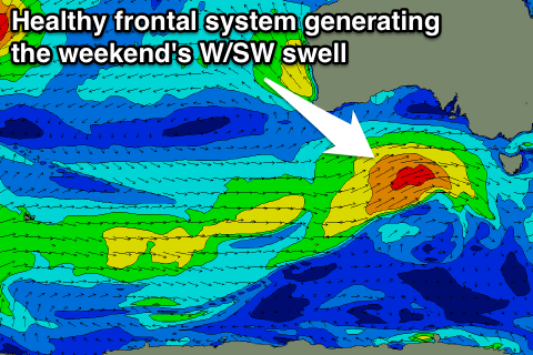
We're looking at a much better outlook into the weekend and beyond as a strengthening polar front forms south-west of WA during the middle of the week and projects ideally right up and into us Friday evening.
This should generate a medium sized W/SW groundswell for Saturday that at this stage looks to be in the 3-4ft range on the Surf Coast and 6-8ft on the Mornington Peninsula (we'll confirm this Wednesday).
A secondary system firing up on the tail of the initial front should keep similar sized waves hitting through Sunday before dropping in size Monday.
Winds will be best for the Surf Coast Saturday and fresh from the W/NW to W/SW with lighter W/NW tending S/SE winds Sunday.
Come Monday on the backside of the swell the Mornington Peninsula should be clean as winds swing back to the N/NE. More on this Wednesday though.