Poor outlook, best early Saturday

Victoria Forecast by Craig Brokensha (issued Friday 7th November)
Best Days: Early Saturday morning exposed breaks, Wednesday morning beaches across both regions
Recap
Yesterday started out small and clean across the Surf Coast with 1-2ft waves across most spots. The Mornington Peninsula offered more size to 3-4ft and conditions improved through the morning as NW winds shifted more offshore before sea breezes kicked in. A slight kick in size was seen through the afternoon but to not to the expected 3ft on the sets across the Surf Coast.
Today the W/SW swell was holding in at 2ft+ around Torquay with bigger and better 3ft sets at the more exposed 13th Beach under a N'ly breeze, while locations east of Melbourne and other exposed parts of the state were the pick with clean surf in the 5ft range. The swell should ease through this afternoon as winds tend more variable.
This weekend (Nov 8 - 9)
You're best bet for a surf over the weekend is early across the Mornington Peninsula or other exposed breaks with a small swell to 3-4ft under an early strong N'ly breeze ahead of a shift to the NW late morning and afternoon SW change.
As expected the deepening low drifting unfavourably south-east through our swell window (attached to Saturday's change) won't produce any major swell for Sunday, and this has even been downgraded a little, with only a small pulse of W/SW swell due through the day.
Size wise the Surf Coast isn't expected to rise above 1-2ft, while the Mornington Peninsula will struggle to get over 3-4ft during the afternoon.
Winds are looking a little worse anyway, with the ridge of high pressure moving in overnight Saturday slowing a little resulting in light onshore winds at dawn from the S'th, tending variable during the morning and then increasing from the SW into the afternoon.
Therefore Saturday morning is the only real window for a decent wave all weekend.
 Next week onwards (Nov 10 onwards)
Monday will start tiny and clean on the Surf Coast under a W/NW breeze but a strong pre-frontal fetch of W/NW gales pushing under the country over the weekend will produce a moderate sized W/SW groundswell for the afternoon.
This swell should build later in the day but with onshore winds from the SW, reaching 3ft on the Surf Coast and 5-6ft on the Mornington Peninsula by dark.
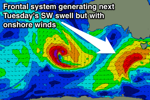
The better increase in SW swell due into Tuesday from the low directly behind this pre-frontal fetch is still on track but has been downgraded a touch.
The Surf Coast should peak Tuesday morning in the 3-5ft range with 6-8ft sets on the Mornington Peninsula but with poor winds from the S/SE in the wake on Monday's onshore change.
Winds are now expected to improve quicker than expected on Wednesday and swing back to the NE on Wednesday morning creating good conditions across across the Mornington Peninsula with a dropping swell from 5-6ft. The Surf Coast should ease from the 3ft+ range.
Longer term there's nothing major until next weekend when we may see some decent SW swell but likely with poor onshore winds again. Check back Monday for the latest and have a great weekend!