Fun Thursday morning, great Saturday

Victoria Forecast by Craig Brokensha (issued Wednesday 15th October)
Best Days: Thursday morning Surf Coast, Saturday and Sunday morning both coasts, Monday east of Melbourne
Recap
Poor conditions all around yesterday with moderate to large and easing levels of swell with fresh to strong onshore winds.
Today onshores have continued with a smaller swell with no decent options for a wave.
This week (Oct 16 - 17)
A new SW groundswell due through tomorrow is still on track with inconsistent but good 3ft sets expected across the Surf Coast with 4ft waves at swell magnets and larger 6ft+ surf on the Mornington Peninsula.
A window of clean conditions should be seen around Torquay with a fresh W/NW'ly through the morning before a S/SW change moves through around midday.
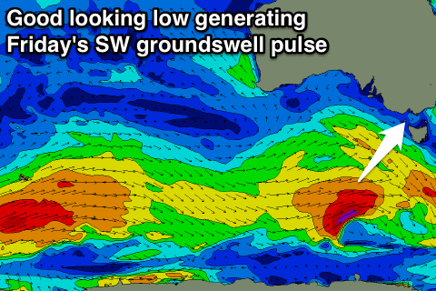 A reinforcing SW groundswell due into Friday has been upgraded in size, with the front moving in along the polar shelf today expected to generate a stronger fetch of severe-gale SW winds towards us.
This should produce a better 3-4ft of SW groundswell across the Surf Coast Friday morning with 6ft to occasionally 8ft bombs on the Mornington Peninsula but winds will still be onshore from the S/SE across the Surf Coast. The Mornington Peninsula may see these winds swing E'ly during the morning but the open beaches will be too big to offer any real decent surf.
This weekend onwards (Oct 18 onwards)
Saturday is still looking great across the state, and Sunday better with Friday's swell expected to ease from the 3ft range across the Surf Coast and 5-6ft on the Mornington Peninsula under local and persistent offshore northerly winds.
Sunday should still be clean on the Mornington Peninsula with a N'ly likely to hold all day, while the Surf Coast will see N/NW tending NW winds.
Into the evening Sunday a new long-range and very inconsistent SW groundswell is due, peaking Monday.
This is being generated by a strong polar front firing up from the Heard Island region, projecting up towards WA while weakening.
Due to the large distance between the source of the swell and our coasts there'll be very long waits between sets, with the Surf Coast expected to only offer 2-3ft waves with 4-6ft sets on the Mornington Peninsula.
Conditions will be best on the Mornington Peninsula though with E/NE winds.
Longer term there's nothing major on the cards so make the most of tomorrow morning and the weekend's waves.