Fun Surf Coast Friday, both coasts Saturday with better swell next week

Victoria Forecast by Craig Brokensha (issued Wednesday 24th September)
Best Days: Friday Surf Coast, Saturday both coasts, Sunday morning east of Melbourne, Monday onwards Surf Coast
Recap
Exposed locations across the state were the pick yesterday with an inconsistent but moderate sized W/SW groundswell to 3-4ft on the Mornington Peninsula under offshore N/NE winds. The Surf Coast was small and clean during the morning before winds tended more E'ly into the afternoon.
Today the inconsistent W/SW groundswell was holding a similar size to 1-2ft on the Surf Coast and 3-4ft on the Mornington Peninsula, with a flukey new S/SW groundswell not really performing too well. Winds should tend lighter NW through the afternoon ahead of a late W/SW change.
This week and weekend (Sep 25 - 28)
Tomorrow will be a day to miss with small waves across all spots and lingering onshore winds from the SW after an change this evening.
Friday is the day to surf though as a long-range and inconsistent but strong W/SW groundswell fills in.
The swell was generated in the Southern Indian Ocean to the south-west of WA, but a weakening front from the progression is currently passing under the Bight.
The morning will be under sized, but still likely in the inconsistent 2-3ft range across the Surf Coast and 4-6ft on the Mornington Peninsula, with a peak due during the afternoon to 3ft+ west of Melbourne, with 4ft sets at swell magnets and 6ft+ waves to the east.
Winds should be offshore from the NW tending W/NW all morning on the Surf Coast, with a swing to the SW due just after lunch.
A slow drop in size is due Saturday from an inconsistent 3ft on the Surf Coast and 5-6ft on the Mornington Peninsula as winds swing back offshore from the N/NW and then variable into the afternoon, likely NE on the peninsula, opening up fun options.
Come Sunday there isn't expected to be much size left with fading 2ft sets max on the Surf Coast and better 3-4ft+ waves on the Mornington Peninsula under strong and warm N'ly tending NW winds.
Next week onwards (Sep 29 onwards)
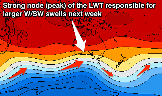
As touched on last update, the outlook for early next week is much better with a couple of strong W/SW groundswells due across the state as a strengthening node (peak) of the Long Wave Trough finally moves in to a favourable position for us, pushing through the Bight Sunday and Monday.
With this we'll see a vigorous polar front steered from south-west of WA up through the Bight towards us and then over us Monday, followed closely behind by a secondary system through Tuesday.
 The models are still a little divergent on the make up of these two frontal systems, but all of them have the strong progression with wind reaching the severe-gale-force range over large and broad areas of ocean.
What should result is an increase in close-range W/SW swell Monday as the front pushes through followed by larger levels of W/SW tending SW swell Tuesday and Wednesday.
At this stage we're probably looking at surf developing in the 3-4ft and 6-8ft range across the Surf Coast and Mornington Peninsula respectively Monday, with 4-6ft and 8ft+ waves respectively through Tuesday before easing Wednesday. Winds will follow the general fresh to strong W/NW to W/SW pattern Tuesday and Wednesday favouring the Surf Coast, but we'll look at this all again on Friday.