Short window over weekend, best Monday morning

Victoria Forecast by Craig Brokensha (issued Friday 13th Jun)
Best Days: Dawn Saturday for keen surfers, Monday morning, Wednesday morning, Thursday onwards
Recap
A new medium sized but very inconsistent W/SW groundswell filled in yesterday but Torquay didn't pick up much size at all, with very infrequent 2-3ft sets at 13th Beach. The Mornington Peninsula was bigger and in the 4-6ft range with clean conditions persisting all day under a fresh and gusty N'ly wind.
Today we've fallen in between swells (but wave heights have dropped a touch more than expected) with yesterday's increase backing off to an inconsistent 2ft across the Surf Coast, while the Mornington Peninsula continued in the 5ft range.
We should see an afternoon kick in new W/SW groundswell though and exposed spots on the Surf Coast should reach 3ft to nearly 4ft late, with 6ft+ sets on the Mornington Peninsula as winds tend variable from the N'th.
This weekend (Jun 14 - 15)
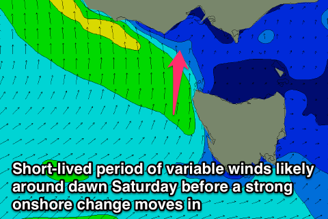 This afternoon's late kick in W/SW groundswell will be still around tomorrow morning, but a strong S'ly change is due to move through during the morning at some stage, although there will probably be a brief period around dawn were winds should be light and variable (especially on the Mornington Peninsula).
One the change hits though it'll be all over, with fresh S'ly winds expected to persist Sunday before easing and tending more SW during the day. This will be a shame as well, because a strong increase in SW groundswell is due, generated by a vigorous polar front that's currently approaching from the south-west.
Size wise, the Surf Coast should peak in the 3-5ft range with 6-8ft sets on the Mornington Peninsula before easing off through Monday.
Next Monday onwards (Jun 14 onwards)
As touched on above, Sunday's SW groundswell will ease through Monday, probably from 3-4ft on the Surf Coast and 6ft+ on the Mornington Peninsula but a reinforcing W/SW groundswell for the afternoon and more so Tuesday should slow the easing trend.
This W/SW swell will be generated by a mid-latitude front producing a fetch of strong to gale-force W/NW winds under the country over the weekend before pushing through Monday afternoon and evening, kicking up a close-range W/SW swell for Tuesday.
Winds are expected to correspondingly swing from an offshore NW'ly around to the W/SW Monday afternoon, while Tuesday unfortunately looks dicey with fresh SW winds, but the Torquay region may see an early W'ly with 2-3ft or so of swell.
Into Wednesday the short-range W/SW swell should ease as winds swing back to the W/NW across the Surf Coast but likely linger onshore east of Melbourne.
Longer term there's nothing too major on the cards besides distant and inconsistent levels of W/SW groundswell Thursday and Friday. Winds however will favour more exposed spots across the state with a N/NE'ly due to persist through Thursday and Friday before shifting more N/NW Saturday. We'll have another look at this on Monday though. Have a great weekend!