East of Melbourne until Thursday, then the Surf Coast
Victoria Forecast by Craig Brokensha (issued Monday 9th Jun)
Best Days: Tuesday and Wednesday east of Melbourne, Thursday onwards across the Surf Coast (besides Saturday)
Recap
The Surf Coast offered the only real decent period of conditions over the weekend with a small clean 2ft of swell Saturday morning before an onshore change pushed through. This strengthened into Sunday creating terrible conditions as a new SW groundswell moved in.
Today the swell is dropping from 2ft on the Surf Coast and 4-5ft on the Mornington Peninsula with workable E/NE winds across selected spots and less favourable SE winds across others. A new ridge of high pressure took a little longer to move in than expected on Friday and this has resulted in winds no fully co-operating from the E/NE across the entire state.
This week (Jun 9 - 13)
Tomorrow and Wednesday will be best on the Mornington Peninsula as today's swell continues to back off and winds persist from the N/NE across the Mornington Peninsula (N/NW on the Surf Coast).
Size wise, tomorrow should be around 3ft+ at exposed beaches east of Melbourne with a slight lift in long-range W/SW groundswell later Wednesday to 3-4ft.
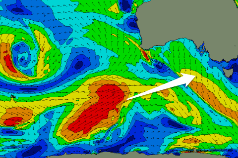
We'll see medium levels of W/SW groundswell filling in from Thursday and persisting right through until around the same time next week as a strong node of the Long Wave Trough moves from under WA this evening, through the Bight and then across us Friday.
This will steer a series of vigorous polar fronts from south-west of WA, up through our western swell window. An initial long-range and inconsistent W/SW groundswell is due to arrive overnight Wednesday and peak Thursday to 2-3ft on the Surf Coast and 4-6ft on the Mornington Peninsula, but a much better and more consistent swell is due to fill in Friday.
 This swell will be generated by the broadest and strongest of the polar fronts, with Torquay due to build to 3-4ft later Friday afternoon, with 5ft sets at 13th Beach, while the Mornington Peninsula should see 6ft+ surf. The swell is expected to hold well into Saturday morning before tailing off through the day.
Winds through the second half of the week will be great for the Surf Coast with a fresh but easing N/NW'ly on Friday and then light NW winds Friday morning ahead of a shallow S/SE change through the afternoon.
This weekend onwards (Jun 14 onwards)
Unfortunately Saturday morning's medium sized W/SW groundswell will be spoilt into the weekend as a deepening surface trough moves in from the west, bringing with it fresh to strong S/SE tending S/SW winds.
Sunday should see an improvement in conditions as the system continues moving east resulting in winds swinging back to the W/NW for a period on the Surf Coast but a mix of easing S/SE windswell and building SW groundswell will create a lot of random peaks and wedges.
The SW groundswell due Sunday afternoon will be generated by a polar swinging in from east of Heard Island and along the polar shelf while producing a fetch of W/NW tending W/SW gales through our south-west swell window.
A good SW groundswell should result and arrive Sunday afternoon, building to 3ft+ on the Surf Coast and 6ft+ on the Mornington Peninsula before easing from a similar size Monday morning. Winds should be favourable for the Surf Coast most of the day with all day fresh W/NW winds, while Tuesday should play out similarly as a mix of W/SW and SW groundswell keep the swell up in the medium sized range.
Tuesday's mix of swells are due to ease into Wednesday and further into the end of the week, with some long-range and inconsistent W/SW groundswell possible beyond this, but we'll review this on Wednesday.

