Strong SE groundswell inbound
Wednesday, 15 June 2022
Strong SE groundswell inbound
Wednesday, 15 June 2022
A funky though strong and prolonged SE groundswell is inbound for the end of the week.
A funky though strong and prolonged SE groundswell is inbound for the end of the week.
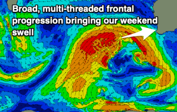
Building stormy waves over the coming days, XL through the weekend with improving winds early next week for a period.
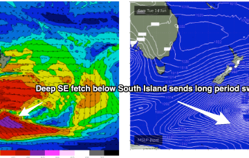
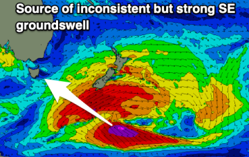
The Southern Ocean gyre is now well to the S and SE of the South Island, generating one last pulse of long period swell for our region. There’s a fresh set of cards to sort through next week with a couple of swell sources on offer.
The South Coast isn't expected to see much size due to the shadowing effects of Kangaroo Island, while winds look hit and miss on the Mid Coast.
There's nothing major on the cards for the Surf Coast while the beaches to the east should have waves with flukey west swells.
The Southern Gyre then sends one more pulse of SE groundswell our way later in the week.
Looking to the end of the week and a trough of low pressure and a weak trade flow combine inside New Caledonia Wed/Thurs.
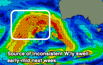
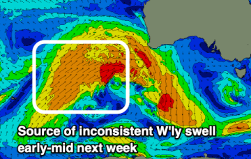
More fronts maintain a synoptic offshore flow (or light winds) for the week and we’ve got plenty of S swell to last the week, albeit at reduced sizes compared to the weekend.
More fronts maintain a synoptic offshore flow for the week and we’ve got plenty of S swell to last the week, albeit at reduced sizes compared to the weekend.
More fronts maintain a synoptic offshore flow for the week and we’ve got plenty of S swell to last the week, albeit at reduced sizes compared to the weekend.