Moderate sized swells from the south-west with tricky winds
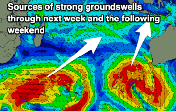
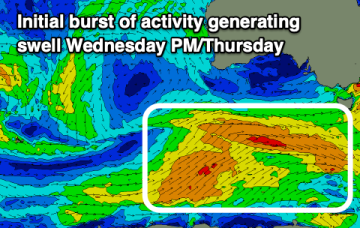
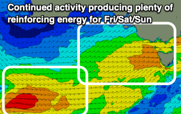
From this afternoon we'll see plenty of size for the South Coast but with tricky winds, improving from Sunday.
This morning was a surprise with the swell coming in earlier, stronger and bigger than expected. There's plenty more to come over the coming days.
Things look to heat up throughout the Indian Ocean heading into next week.
A fetch of a different magnitude working on an already active sea state Fri should see a much more substantial series of S swell pulses beginning later Fri.
We've got increasing winds and swell due from the middle to end of the week, possibly sizey from the south on the weekend.
High pressure sitting up at sub-tropical latitudes is allowing a very active series of fronts to penetrate NE into the Tasman Sea. A very slow moving monster high tracking into WA longitudes is anchoring a sustained SW flow as the fronts ride up it’s extended flank from the Southern Ocean into the Tasman. We’ll see multiple S swell pulses from this set-up, becoming stronger over the weekend.
Smaller surf this week but with cleaner conditions. The fronts and swell will kick back in next week.
Tomorrow looks great down South ahead of a trickier period of weaker swells and varying winds.
High pressure sitting up at sub-tropical latitudes is allowing a very active series of fronts to penetrate NE into the Tasman Sea. A very slow moving monster high tracking into WA longitudes is anchoring a sustained SW flow as the fronts ride up it’s extended flank from the Southern Ocean into the Tasman. We’ll see multiple S swell pulses from this set-up, becoming stronger over the weekend.
The coming period will consist of weaker swell energy but with workable winds for protected spots.