Lotta inbound surf from multiple directions

Sydney Hunter Illawarra Surf Forecast by Ben Matson (issued Wed Dec 20)
Features of the Forecast (tl;dr)
- Building, windy S and SE swell Thurs, peaking Fri, easing Sat
- Building E/NE swell Fri, peaking Sat, easing Sun
- Best days Sat and Sun
- Plenty of potential for next week
Recap
Peaky NE swell built a little higher than expected on Tuesday, reaching 2-3ft at most NE facing beaches but up to 4ft at some of the more reliable swell magnets. Wave heights have eased from the NE today but we’ve seen building S’ly swells under fresh to strong S’ly winds. Size is now showing a bumpy 3-4ft at south facing beaches.
This week (Dec 21 - 22)
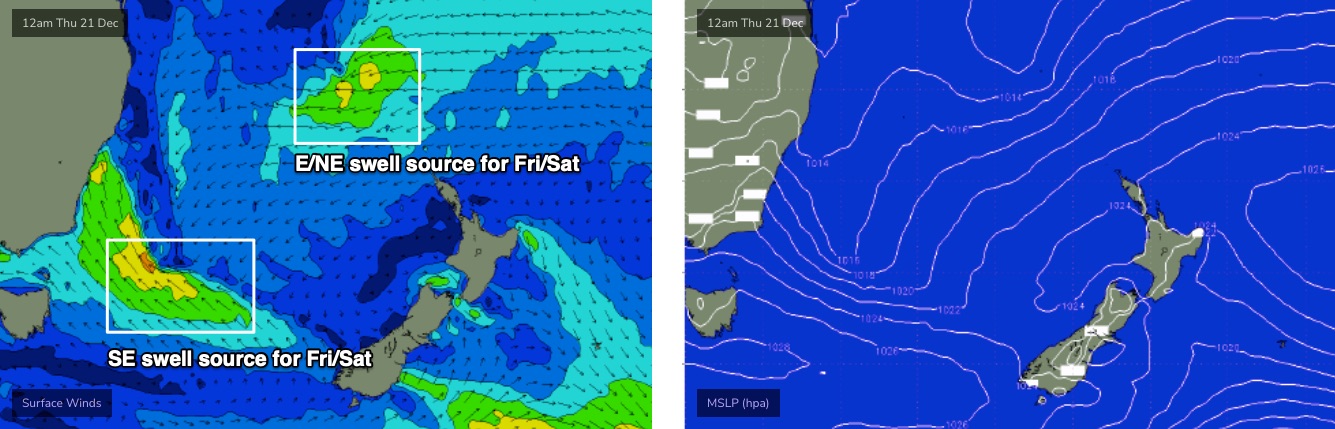
A broad trough stretching the length of the NSW coast will form a surface low well east of Eden early Thursday, enhancing an already-strong S/SE flow through our immediate southern swell window.
Today’s surf is mainly local windswell, and will ease back temporarily early Thursday before a new combo of mid-range S’ly and SE swells build through the day (sourced from two seperate fetches around the low). South facing beaches should peak later Thursday, holding into early Friday with sets between 4ft and maybe 6ft, though the accompanying southerly winds will render exposed spots very poor in quality.
Sheltered southern ends and points will fare much better throughout this time frame.
Bigger waves are likely on the South Coast owing to a better alignment of the SE fetch around the southern flank of the low.
Also in the water on Friday will be a new E/NE swell generated from a developing E’ly dip currently pushing south from about New Caledonia.
This swell will be much smaller - maybe some 2-3ft sets - but it’ll add nicely into the mix at southern ends as it builds into the afternoon (smaller surf expected from this source earlier).
For what it’s worth, model guidance has marginally strengthened the synoptic flow adjacent the coast on Friday morning so the chances for an early SW breeze has been downgraded.. though it is a possibility across one or two regions (such as the Northern Beaches). In general, don’t expect it to eventuate.
This weekend (23 - 24)
The weekend still looks great.
The Thurs/Fri combo of S and SE swells will be easing, though still pretty punchy, however we’ll see the E/NE swell building towards a peak during the afternoon. Both sources should be worthy of 3-4ft sets though the balance will tip towards south facing beaches in the morning.
Local winds look pretty good though a lingering southerly will create a few issues at some - but not all - coasts. We’ll probably see a reasonable spread of morning SW winds, tending moderate southerly but then becoming variable late in the day. So, expect a few lumps here and there but generally fun conditions all round.
Light variable winds and sea breezes will then occupy Sunday as all swell sources gradually ease from a much slower 2-3ft.
Next week (Dec 25 onwards)
Complex coastal troughs are still on the agenda for next week.
Model guidance is quite mixed on specifics, but the broad synoptic trends are in agreement so despite nothing to pin down specifically - except a slow start on Monday - we’re looking at plenty of waves throughout next week.
Let’s leave it a few more days to see how the models consolidate, so we can start to plan a more effective use of our time.
See you Friday!
Comments
Surely Crystals and TubbaBird are getting around it
Forecast looks bang on, easy 4 to 6 feet at my locals down in the Illawarra. Quality is pretty poor though. Hoping tomorrow arvo comes up with the goods (per the forecast notes) down the coast from where I live.