Extended run of large surf ahoy!

Sydney Hunter Illawarra Surf Forecast by Ben Matson (issued Wednesday 8th Feb)
Forecast Summary (tl;dr)
- Fun south swell Thurs, easing Fri, plus some small east swell too; generally light winds and sea breezes
- Small leftovers Saturday (though low probability for flukey N'ly groundswell at one or two spots)
- Large E/NE swell from TC Gabrielle building Sun, holding Mon/Tues, easing Wed, generally light winds and sea breezes
Recap
Small surf on Tuesday as Monday’s southerly pulse eased back, ahead of a renewal of E’ly swell and S’ly swell today with sets in the 3ft range, occasionally bigger at south swell magnets. Generally light to moderate onshore winds taking the sheen off things.
This week (Feb 9-10)
Thursday looks like it’ll deliver a similar round of waves as per today, with E/NE winds freshening (outside chance for variable for periods in the morning) and a peaky mix of mainly south but also east swell in the water. South facing beaches should see the most size, around 3ft across most coasts but possibly as high 3-4ft on the Hunter though beaches not open to the south will be smaller.
It's not a great wind direction for most regions, so unless you luck into a variable window, it may not be worth the effort.
This south swell will fade slowly into Friday and the east swell will hum along, both energies just enough to keep exposed beaches rideable. We may also see some minor NE windswell in the mix too.
Friday’s wind direction will likely clock more to the northern quadrant though no major strength is likely, and variable periods are expected in the morning.
So, Friday will have the better conditions but Thursday will have the most size.
This weekend (Feb 11-12)
Saturday looks to be a low point in the surf department, with early light winds tending NE and freshening into the afternoon. Small slow beaches will be on offer if you’re desperate.
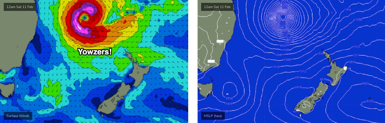
It’s worth noting that the swell models are showing some unusually long period north swell tracking along the East Coast (arriving overnight Friday, holding through Saturday), however this will have been sourced from TC Gabrielle, which - at the time of generation - was tucked up inside the central/western Coral Sea, behind a number of land barrier shadows.
It’s certainly plausible that some long period energy may filter into a handful of extremely well exposed spots where the bathymetry is efficiently aligned towards swells displaying these characteristics. However, having seen only a handful of these kinds of synoptic setups in the last decade or two (and having never quantified any surf from such systems) it’s extremely difficult to have confidence in the surf potential.
So, I’m not expecting anything. Rather, I'm flagging this to your attention, should you care for some remote, low-fruit-bearing detective work.
Sunday is a different kettle of fish.
Over the next couple of days, TC Gabrielle will strengthen considerably and track south-east through the Coral Sea, enroute to the Northern Tasman. Most of its initial journey will generate flukey, low reliability swells for Southern NSW, however on Friday and Saturday we’ll see the cyclone muscle up against a large high near New Zealand, which will broaden and lengthen an impressive easterly fetch along its southern flank as TC Gabrielle undergoes extra-tropical transition.
And it’s these developments - fair and square within our swell window - that will generate a large four-day easterly swell, trending steadily upwards across Southern NSW on Sunday.
Although the early morning will be smaller, we should be looking at 6-8ft sets by close of business on Sunday. Local winds look to remain out of the NE, again without any significant strength and probably variable for a period in the morning. The afternoon may get a little bumpy though.
We’ll firm up the size and timing (and wind) in Friday’s notes.
Next week (Feb 13 onwards)
The slow moving nature of (by this time) ex-TC Gabrielle will result in a long-lasting swell event through Monday and Tuesday in the 6-8ft range, before size then eases from 4-6ft on Wednesday.
It's worth nothing that the strength of TC Gabrielle has the potential to generate much larger waves than what I've mentiened above, however the core fetch (see below) will be aimed into the Coral Sea - away from Southern NSW - so I'm expecting 'smaller' size-band energy at locations south from the Mid North Coast.
But, small tweaks in the model guidance could tilt the trend up more over the coming days - if anything, early Monday could see a period of even bigger surf than I have indicated. Let's be cautious for now. Either way, it's very likely to be large and powerful.
As for local conditions, amazingly, we’re still anticipating a weak pressure gradient across the East Coast so conditions should be clean with light winds. Bear in mind that swell direction will be slightly north of east, though swells of this direction and sourced from the north-eastern Tasman Sea tend to generate a reasonably uniform coverage of size anyway.
There’s nothing else on the long term radar behind this, so let’s see how the model guidance is shaping up on Friday.
See you then!
Comments
Letttttttssss go
Hard one to pick what section of coast I want to score
Gabby is a beast of a system..a few novelty spots might get run ..
No style though.
Is it anything like the synoptic setup of TC Funa in 2008? Was on NE Tas coast for that one and wow.
Been on the wave model rollercoaster since Monday and it's been a flat track the whole way. Can't recall seeing a bountiful forecast staying so steady.
6-8ft on the peak of the swell?? Or maybe bigger??
Carnage across the Coal Coast this afternoon, Stu will have more to say but seeing images of 2/3 submerged cars, streets underwater and waterfalls off the escarpment along the Sea Cliff Bridge.
Starting to clear now but the Coal Cliff is gonna have some new sand formations tomorrow as the rain came off the escarpment like a waterfall and rushed to the coast, flooding all the creeks and in turn the streets and houses too.
Real mess around here now. Twenty or more SES screamed north and haven't returned; apparently a landslip near Coalcliff, though not confirmed.
Yes re the storms Craig. Good thing they built that sea cliff bridge.
This cyclone is a stonker. Agree with Stu that the forecast hasn’t changed much, but if at all it’s got more intense and lined up even better, or worse depending on whether you own a home at Collaroy, Wamberal etc.
Will be doing a bit of spectating from Sunday for a few days.
Wonder if this sicko survived the downpour. 20kt E winds and now a white-out..
View from Scarbourough of sediment flowing down from Stanwell Park:
Incredible!
Amazing Stu. Stanwell will have some different banks, which I might try once the water cleans up.
We got spared the worst of it down Shellharbour way it seems. Wollongong got smashed way worse.