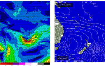
Make the most of the surf early-week
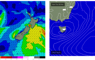
Try and surf today and through tomorrow before winds deteriorate later week, spoiling a good SW groundswell for the weekend.
Into next week and the slow moving pattern remains entrenched through most of next week with a “stuck” high pressure to the SW of WA maintaining an ESE-SE flow- depending on the positioning of an inland trough.
Building swells are expected regionally over the weekend, though they’ll be sourced from a polar low sequence below the continent.
High pressure is now weakening with the angled monsoon trough stretched along the edge of the Coral Sea still supplying sufficient pressure gradients to maintain a tradewind flow which is generating small, fun surf.
No great change to the weekend f/cast. A small trough of low pressure off the Gippsland coast brings S’ly winds Sat with small amounts of S swell wrap as a large frontal progression traverses waters below the state.
Today’s surf will increase more prominently through Saturday towards a peak on Sunday morning.
Long period S swells will be the dominant swell trains next week (for NENSW) as a complex deep low traverses the far southern Tasman Sea and becomes slow moving in New Zealand longitudes.
Long period S swells will be the dominant swell trains next week as a series of deep low traverse the far southern Tasman Sea and become slow moving in New Zealand longitudes.
No great change to the slow moving pattern which is seeing a blocking high (1034 HPa) well to the SW of the state maintain a ridge of high-pressure across the SW with an inland trough enhancing ESE-SE winds through the morning. This stuck pattern looks to remain in place right through the end of this week and over the weekend, and even into early next week.
High pressure has now moved into the Tasman, reinforcing tradewinds in the Coral Sea.