The return of S swells
Sydney Hunter Illawarra Surf Forecast by James Casey (issued Friday 14th May)
Best Days: Sunday, Tuesday, Wednesday
Outlook:
- Smallest it’s been for a while tomorrow (Saturday)
- 3-4ft S swell to fill in late Saturday into Sunday with offshore winds continuing
- Winds go more out of the S at the start of the new week with a larger S swell set to peak around 4-6ft on Tuesday into Wednesday. Winds offshore early light seabreeze Tuesday, stronger NE breeze for Wednesday arvo.
- Swell to fade into Thursday
- Another S swell look to fill in for the end of next week
Recap
There’s been fun waves over the past couple of days as the E swell continues to ease. Winds have been mostly offshore although yesterday a light onshore flow settled into the afternoon creating a little bit of bump to what has been pristine conditions.
Today waves are in that 2-3ft range, bigger for the Hunter and a little smaller for the Illawarra as the E swell peters out. With offshore winds continuing it’s a good day for a paddle. Offshore winds will continue this afternoon.
This weekend
The last of the E swell will fade into the start of the weekend with just 2ft waves on offer tomorrow morning. A new S swell will begin to show as winds around the western flank of a trough and associated low generate a bit of fetch. This new S swell will peak on Sunday morning up around that 3-4ft range for S swell magnets.
Winds will mainly be offshore thanks to the trough remaining off the coast. The mornings will be more offshore with Saturday afternoon looking the windiest with SW winds. Sunday will see winds strongest in the morning tending lighter and more offshore as the day goes on. All in all it’s looking like a decent weekend of waves. 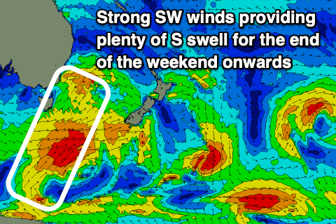
The new week
The S swell will ease into the start of the new week before a new S swell shows up late Monday and into Tuesday with a stronger cold front passing to the south. Winds will start off W/SW early but tend more S and strengthen as the day goes on
Tuesday will see the peak of the swell, reaching the 4-6ft mark for S swell magnets, with the largest sets for the Hunter. Winds will be W/SW early but weaken and tend light and variable in the afternoon with a weak seabreeze out of the E/NE.
Another pulse of S swell will arrive on Wednesday and expect it to keep wave heights around that 4-6ft mark for S swell magnets with a bit of longer period energy. Winds will again be offshore Wednesday morning but winds will turn around to the NE by the afternoon making it a bit bumpy unless you are at a south facing beach, which will be copping most of the swell too.
The swell will fade into Thursday before another cold front moves through for the end of the week and into the weekend but more on that in Monday’s update.