Average surf for a bit, then a decent pulse from the S/SE

Sydney, Hunter and Illawarra Surf Forecast by Ben Matson (issued Monday 8th February)
Features of the Forecast (tl;dr)
- Small average surf until Thurs; generally S'ly though some leftover E/NE swell early Tues
- Decent S/SE tending SE groundswell for Fri, with light/mod N'ly winds developing
- Average weekend ahead
- Long term outlook into next week is promising
Recap: It’s been a disappointing couple of days in the surf department. Whilst conditions generally played out as expected - with Sunday morning producing nice options across most open beaches under a light morning offshore breeze - Sunday’s E/NE groundswell never reached its predicted size, and consequently this morning came in a little under budget too, though with the expected southerly winds. It’s a shame, as Northern NSW and SE Qld came in bang on expectations for the entire week-long week event (reaching 6-8ft sets at some locations on Friday, late Saturday and early Sunday) - but in hindsight, I didn’t properly note the changing evolution of ex-TC Lucas’ synoptic structure throughout last week, in that by Friday it’d aimed all of its core fetch away from Southern NSW. I attribute part of this to a slight brain-fog induced by Friday’s pumping surf up here on the Tweed Coast, and my haste to get out the door to sample some of its fine wares. But let's be honest, that’s a piss-poor excuse. For the record, the weekend also saw 3ft of peaky NE swell and we’ve seen some S’ly swell in the water this morning. Size maxed out at about 3-4ft most days, with coverage varying from coast to coast.
This week (Feb 9 - 12)
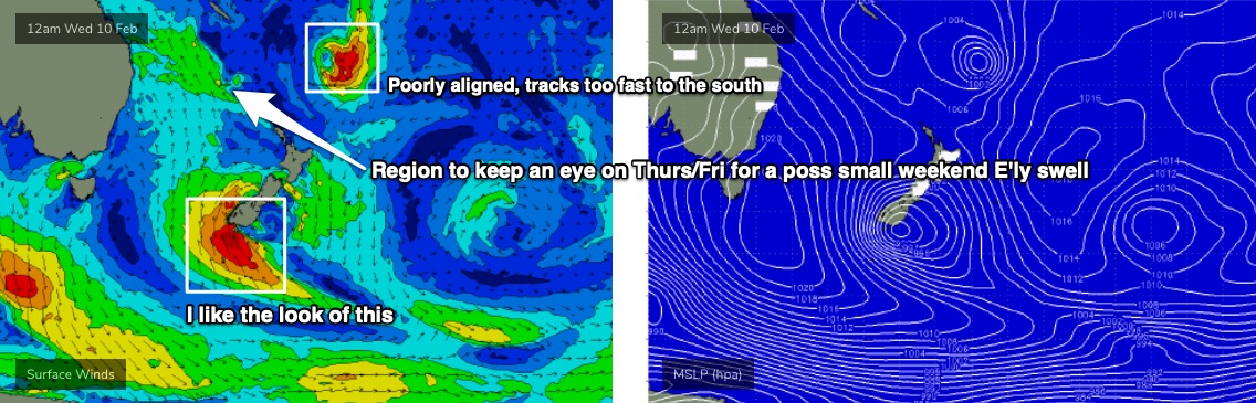
A broad trough through the Tasman Sea isn’t generating much surf for us right now, but a secondary front racing up below Tasman today will merge with this trough, forming an impressive Tasman Low off the SW tip of New Zealand’s South Island.
As such Tuesday should see slowly easing E/NE swells from the weekend. Today managed 3-5ft sets in Northern NSW but we’ll probably be down to a slow 2ft in Southern NSW on Tuesday, plus a similar size of short range S/SE swell.
A second, slightly larger S’ly swell from the aforementioned front should nudge wave heights very late Tuesday (South Coast) and Wednesday (everywhere elsewhere) but only a little bit, perhaps some 2-3ft sets at south facing beaches. Expect much smaller surf elsewhere.
As for conditions, we’ll see the synoptic breeze remain out of the S/SE but become much lighter in strength, so pockets of variable winds are possible early morning - though with some residual lumpiness across the coast. Light to moderate S/SE breezes are expected throughout most of the day though.
On Thursday, swell periods should muscle up a little more from the S/SE thanks to the developing Tasman Low, though I’m not confident that we’l see much more than 2-3ft+ at south facing beaches, perhaps a little more through the Hunter. Similar conditions are expected with mainly light variable winds tending moderate S/SE.
Friday is where things get really interesting.
The Tasman Low off New Zealand is expected to reach peak strength on Wednesday morning (see below) and this puts an arrival time of peak energy sometime on Friday morning across Southern NSW. It’s a flukey swell direction as the fetch will extend around the SW tip of NZ, and I’m confident for some very good waves with swell direction trending S/SE thru’ SE. Relatively long swell periods (13-14 seconds) should boost surf size across various reefs, with sets pushing 4-5ft+ at times though it’ll be inconsistent. This direction is usually favourable as it provides a degree of size-uniformity across the coast.
The only tricky aspect for Friday is a freshening pre-frontal northerly wind, which may spoil conditions at exposed spots. But, it should be light early morning and we should see plenty of energy in the water by this time.
Also in the water later this week will be some small long period E/NE groundswell from a tropical depression near Fiji (TD09F) which may intensify into a tropical cyclone in the next day or so. Unfortunately, it’s expected to now track rapidly to the south and therefore I’m not expecting a great deal of swell from it, just some faint lines on Friday and Saturday, certainly not worth working around.
This weekend (Feb 13 - 14)
Looks like a slow weekend of waves.
Friday’s S/SE groundswell will ease rapidly, perhaps some early 3ft sets on Saturday, down to 2ft by the afternoon and smaller for Sunday.
The aforementioned E/NE groundswell may also provide some small lines but I can’t see there being much more than a stray foot or two every fifteen minutes.
Otherwise, the only other area of interest to monitor is a small trough in the north-eastern Tasman Sea, sitting at the tail end of a modest ridge pushing through the Coral Sea. On Thursday, it’s expected to deepen slightly and may possibly retrograde to the west. It’s early days but this could be a source of fun, useful E/NE swell by Sunday.
The models are also showing a small low in the south-western Tasman Sea though I don’t hold much hope for any significant swell at this point in time. It may affect local winds though (early indications light Saturday, freshening S'ly Sun).
Anyway, there’s a few things to keep an eye out for. Let’s reevaluate on Wednesday.
Next week (Feb 15 onwards)
Long term suggests a whole region of unstable troughiness throughout the Tasman Sea next week, which - whilst not conclusive at this early stage - is pointing to a renewal of easterly swells for the East Coast for the following week. I’m mildly excited at the long term prospects, to be honest - it’s all pointing in the right direction for some very good waves. Just need a few more days to confirm the trends.
See you Wednesday!
Comments
Yes fortunately I didnt believe you about Sydney getting a lot of swell
and flew to the gold coast to collect some gold. NOTE
Snappa is fat and horrible sort of fun but a long way from super bank more like bells.
Green mount has some excellent sections definitely not a tube fest but some
super fun waves.
Kirra has some mad barrels but dosent run right through which is great because
it gives surfers down the line a go.
#ShouldHaveGoneNorth
Drove back on Sunday from north of Coffs, it was solid but a downgrade from the previous day with better winds, 3-4’.
About 2 hours south I dropped in to a well known point break, f#*k me, but the town was chockas, seemed like school hadn’t gone back, what were they all doing there. 4-6’ solid swell and coming through regularly, more trade swell than ground swell, and so much bigger than where I left. Perfect conditions for the hundred or so surfers there, but there wer 30 take off spots so not really a problem.
Cennie coast by late arvo, bloody near no swell to be seen, Sou Easter was into it and no sign of the swell I had seen earlier. Seems it really didn’t get down here.
Strangely, pesky se winds yesterday and this arvo have blown all day and then gone quiet around 5.00 pm. Not expected that way.
So, did Sydney and surrounds see much of this swell?
No
You're killing me Batfink! I was going to strike up to the same point over the weekend but decided against it in the end thinking that the winds might be better round here. What a hoax swell for southern NSW, which was made even harder to endure by seeing just how great it was up north!
The swell was a bit of fizzier around the centy coast .. had more fun on the peaky swells the last few days only a few out..