Flag the next few days; next week and beyond looks very promising

Sydney, Hunter and Illawarra Surf Forecast by Ben Matson (issued Wednesday 27th January)
Features of the Forecast (tl;dr)
- Solid, building short range swells Thurs/Fri but wind affected
- Easing winds, abating swells over the weekend, fun tho' nothing special
- Extended period of solid E/NE swell from Wed onwards
- Chance for a large S'ly groundswell next weekend
Recap: Peaky NE windswell and underlying S’ly groundswell managed 3-4ft sets on Tuesday, with early light N/NE winds freshening through the day ahead of a S’;ly change that reached Ulladulla at 6:30pm, Wollongong around 8:30pm and Sydney around 10:30pm. Fresh southerly winds have persisted today with a mix of small easing leftover NE swell and building S’ly swell from the fetch trailing last night’s change, which has increased south facing beaches from 2ft to 3-4ft through the arvo, however many spots have remained quite bumpy.
This week (Jan 28 - 29)
Looks like a couple of crappy days ahead. However, size won’t be an issue.
A ridge trailing last night’s change will strengthen across the southern half of the Tasman Sea, pushing in across the Sydney, Hunter and Illawarra coasts, maintaining gusty SE tending E’ly winds on Thursday, easing slowly through Friday and veering more E/NE through the day. There won’t be many locations offering protection from this wind direction, so clean options will be very hard to find.
Interestingly, a stalled trough across the Mid North Coast looks to have an axis point closer to the northern Hunter region on Thursday. Whilst locations just south of this (i.e. Central Coast, Sydney) will see the full effects of a tight E’ly squeeze, there is an outside chance for light winds north from Newcastle (though, a much better chance north from Seal Rock or better still, Forster).
As for surf, we’re looking at building, punchy swells on Thursday whose direction will accompany the local wind field - so, backing slowly from the SE to the E and then E/NE. Most coasts should build from 3-4ft to 4-5ft through Thursday, holding this size into Friday before gradually easing, but locations across the Hunter close to the trough’s axis (and thus directly in the firing line for the associated stronger winds) could see bigger surf peaking in the 6ft range.
Conversely, as you head south from the Illawarra, wave heights will gradually tail off in size.
Unfortunately, it’ll be hard to find worthwhile options over the next few days, but broadly speaking, southern corners will be your best option on Thursday, northern corners on Friday (those not overpowered by the short range swell, anyway).
It’s also worth mentioning that we’ll see a small S’ly swell in the mix over the coming days (impossible to detect beneath the local noise) plus some minor E/NE trade swell from an unrelated ridge stretching across the Northern Tasman Sea, which has generated excellent 3-4ft waves in Northern NSW and SE Qld over the last few days.
This weekend (Jan 30 - 31)
We’ve got plenty of surf due for the weekend, with improving conditions by Sunday - though wave heights will be easing by this time.
The swell will be sourced from both ridges in the Tasman Sea, however they’ll be weakening slightly on Friday which means surf size will gradually ease. Saturday morning should still manage 3-5ft sets at exposed beaches north from the Illawarra (smaller to the south), before easing to 2-3ft+ through the day.
We’ll see winds turn more to the N/NE and ease back in strength, with pockets of light variable winds starting to crop up. But conditions will be a little wobbly at exposed locations.
Sunday should level out around 2-3ft at exposed beaches north from the Illawarra, and light variable winds will settle across the region early on, under the influence of a weak trough. A southerly change may push across the coast through the day, reaching the Illawarra mid-morning and Sydney late morning, but current expectations are it won’t have too much strength and with the swell direction around to the E/NE thru’ NE by this time, there’ll be plenty of small workable options at protected southern ends.
Next week (Feb 1 onwards)
It’s still a little too early to be confident in the specifics regarding next week’s outlook, but broad brushstrokes remain much the same as discussed on Monday.
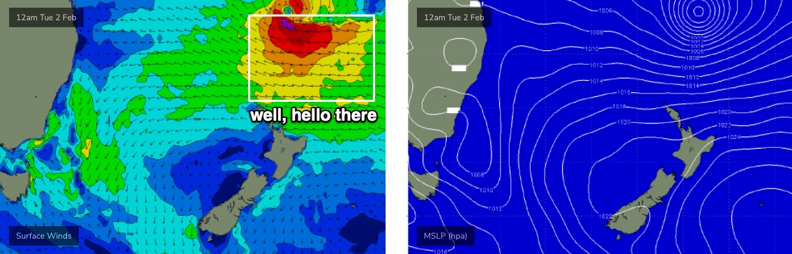
A passing MJO phase across tropical regions is expected spin up a couple of tropical cyclones, whilst a broad supporting ridge north of New Zealand maintains an active region of underlying easterly trade swell across the northern Tasman Sea. The synoptics certainly look pretty juicy (see below).
Monday and perhaps Tuesday are expected to be a little undersized, with the main energy now expected to push through strongly on Wednesday, continuing through Thursday and at this stage we’re likely to see strong swells continuing through into the weekend. A mid-week peak is still pegged around the 4-6ft mark and a slightly bigger pulse later in the week can’t be ruled out at this stage either.
And, it’s quite likely that this E/NE energy won’t be the only swell source in the water. A cut-off low in the southern Tasman Sea around Tuesday is expected to set up a decent pulse of S’ly swell around Wednesday, and a much more significant Tasman Low due to develop east of Tasmania on Friday could very well generate a big S’ly groundswell for next weekend that could easily overshadow the pre-existing, solid E/NE swell.
Time for a few push ups, eh?
See you Friday!