Low set to 'bomb' in the Tasman

Sydney, Hunter and Illawarra Surf Forecast by Craig Brokensha (issued Monday 13th July)
Best Days: Experienced surfers only in protected spots Wednesday through Friday, Saturday experienced surfers, Sunday, Monday
Recap
A mix of leftover S/SE swell and small E’ly energy Saturday to 2ft on the sets with clean conditions and variable winds all day, while a new S’ly groundswell provided stronger 3ft+ surf yesterday with light winds and afternoon storms.
Today there’s still inconsistent sets to 2-3ft out of the S’th, with a smaller E’ly swell to 1-2ft.
This week and weekend (Jul 14 - 19)
In the wake of yesterday afternoon’s storms the first burst of cold air moved in and currently we’re seeing a surface trough sitting just off the coast, feeding off a deeper cold pool in the upper atmosphere.
This will result in the development and deepening of a significant low pressure system in the Tasman Sea, with an infeed of strengthening E/SE winds on its southern flanks as westerly breezes freshen to the north.
The axis of the trough is currently around Narooma and we should see building levels of E/SE swell with clean conditions anywhere north of this axis later today, onshore, wet, stormy and poor to the south of it.
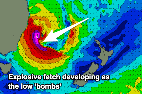 As this trough drifts further offshore we’ll see the formation of a broad area of low pressure in the Tasman Sea (not classified as an East Coast Low), with it now expected to ‘bomb’ (discussed in more detail below).
Regardless of the classification, we’re set to see a significant and prolonged swell event out of the SE this week, easing only gradually into the weekend as the direction swings more E/SE.
So through this evening we’ll see E/SE winds continue to broaden and strengthen until the low forms proper early tomorrow morning.
With the central pressure forecast to drop from 1014hPa to 988hPa in the 24hour period from 7pm today to tomorrow, the low will ‘bomb’ and as it does so, an explosive fetch of severe-gale to storm-force SE winds will develop on top the growing sea state generated by the strengthening winds before it. This will occur through tomorrow, ahead of a slight weakening and broadening of the low Wednesday.
We’ll see an elongated fetch of SE gales through Wednesday with core winds likely being a touch stronger as embedded lows rotate around the main centre.
Looking at the expected trend in size, and early tomorrow will see moderate sized levels of E/SE-SE swell, large down South but quickly becoming large out of the S/SE-SE as the western arm of the low projects up the coast. This will bring strong S/SE tending S'ly winds and a rapid increase in swell to 6-8ft by late afternoon and likely bigger on dark, while the large pulse of SE groundswell (from the strongest part of the fetch) is due Wednesday morning.
The bulk of the strongest fetch is aimed towards Newcastle and the Mid North Coast, but the Sydney region should see 10-12ft sets and with the direction and period (bigger deep water reefs), and even southern corners will be large and only for the very experienced with the east in the direction. Expect a touch less size on the south coast and sets likely to 12ft to occasionally 15ft across the Hunter magnets and offshore bomboras.
Thursday may be a little smaller, but with a secondary projection of SE gales towards us through Wednesday I can’t see the surf dropping too much at all from Wednesday. Maybe a touch less period but similar in size and around 10ft in Sydney, 10-12ft across the Hunter.
Winds look only favourable for southern corners with fresh to strong S/SW breezes, more SW across the Northern Beaches and possibly even tending W/SW times during the morning Wednesday. Thursday will play out similar but with a little less strength to the local winds.
From Friday we should start to see the size easing though not dropping below 6-8ft out of the SE owing to an upper level ridge cradling the low throughout the whole week as it slowly weakens, moving off slowly east through Saturday but more so Sunday.
With this we'll see winds on its south-western flank weaken through Wednesday evening, while over towards New Zealand, a Cook Strait fetch of E'ly gales will develop, persisting into Thursday and Friday but dropping to strong in strength from Thursday afternoon.
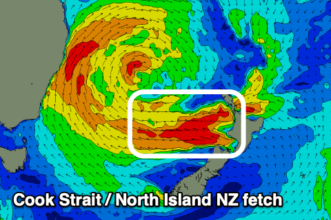 A reinforcing E/SE groundswell will be seen from this source, likely showing later Friday but peaking Saturday morning, keeping the surf up around 6ft+ on the sets. An easing trend should be seen into the afternoon but more noticeably from Sunday as the size and period drop, with easing sets from 4-5ft or so, smaller again Monday though likely hanging in at 3-4ft.
Coming back to the local winds and we'll see fresh to strong S/SW breezes continuing Friday, tending SW across selected locations through the morning, while as the low pushes east and weakens, we'll finally see lighter W/SW offshores Saturday morning ahead of NE sea breezes.
A front will then move through Sunday bringing N/NW-NW winds and then stiffer W'ly breezes Monday.
Longer term we're looking at a renewal of moderate sized S'ly swell through the middle to end of next week as a cold front pushes up the Tasman Sea, but we've got plenty to deal with in the short term.
Comments
Brilliant Craig, thanks for all that you do. Can’t wait to get amongst it.
New E/SE energy from the bottom of the trough started to fill in across Manly mid-afternoon, 2ft to occ 3ft sets.
Are you sure on the winds there? Most forecasts are saying s to sw winds. Not se
Check the day, also no mention of SE winds...
Couldn't see a reference to SE winds either.....besides, as we know due to the land creating friction so on and so forth, which steers the surface winds towards the S and SW.
Edit: Maybe you mean SE gales which are mentioned in the context that they will be SE out over the Tasman sea, not at the beach.
My mistake
All good.
How's good is that second wave of swell being forecast from West of Nth NZ!
No matter what you call it, an East Coast low, a broad area of low pressure, or a bombing low, one things for sure, it's going to pumping for days!
You know something's brewing when the storms are heading in the opposite way to the surface winds..
https://www.weatherzone.com.au/radar/nsw/sydney/128km
any idea about tomorrow? no mention of tuesdays swell or winds?
Ha, look closer it's there. Morning is likely 4-5ft or so Sydney, larger to the south. But the winds..
ahh sorry mate, I see now.. any chance of offshores on the cenny coast early? or is that southerly hitting at dawn
It's not in at 4am but in by 7am. With the rain and lack of light I'd say chances are slim unfortunately. Set the alarm and check the obs for a small window.
yep standard practice for me mate thx
Southerly just hit Manly.
Incredible viewing..
Wow, kabooming!
What a beautiful system. Gorgeous.
How's the Newy cam today....kind of sums up the day haha
Easy 8ft across Avoca already..
Great window of waves 8:30-11:00 this morning
As often seen with these rapidly intensifying systems, the size across southern NSW is already above what was expected later today. Looks 8-10ft in Sydney.
Yup its pretty wild and woolly down South. A couple of novelty protected options breaking proving some fun.
Also this system easily reached the explosive cyclogenesis requirements, as per this article in 2018.. https://www.swellnet.com/news/swellnet-analysis/2018/01/09/developing-superbomb-indian-ocean
The exact meteorological definition is that this 24hPa drop in 24 hours occurs at 60degrees latitude (called 1 bergeron), but if the storm is at a lower latitude (more towards the equator) less of a pressure drop is required for it to be classified as a 'bomb'. For example at 25degrees only a drop of 12hPa is needed for it to be classified as a 'bombing low.'
So at around 35deg South we don't the need the low to drop 24hPa, though forecasts are still showing this is currently occurring.
Manly Buoy reached 10m peak with 5.8m swell @11.4s 11am (10 foot?), its a bit smaller but messy down here on the Illawarra I reckon 6-8 foot where I live) but for about 30 mins and hour or 2 ago the wind went south west and it looked almost surfable lol.
I was out during this SW window and it was great
It'll be interesting to see whether the swell continues to build into this evening or if we are seeing an early peak. Would be cool to see it blasting through Sydney at 15ft even though it's all much of a muchness when gale force winds are about.
Anything changed for the pulse tomorrow?
Nope :)
I wonder why the swell jumped so quickly?
Was it because:
.The winds came "around the corner" and the swell began coming our way (not likely due to the way this system formed)?
. Simply a sudden increase in low pressure and wind ?
. A change in the wind direction out at sea?
. A small captured fetch developed?
Or a combo of a couple of these?
If i was guessing i'd go with captured fetch going by the above graphic.
Yep, active sea state and capture fetch projecting up the coast.
anywhere rideable?
Yeah saw a few spots today. Nowhere great though. Tomorrow's shaping up as serious.
Deadmans was big and rideable with about 15 out.
Tomorrow's WOTD was shot there this arvo.
Pretty damn good too.
Yea got good waves this arvo with a crew of about 3 getting even better one’s around the corner where bigger baby makers are required
Stockton at lunchtime
Pirate point? Never seen stockton less than rubbish. Do you know something I dont know
Nope, don’t know the area at all. Went for a drive to check out the erosion
I love this site for visualising the wind field. Can skip forward and back in time too. https://earth.nullschool.net/
Solid!
Sizey!
Reports of a surfer missing at Coogee. Hope all is okay.
It's enormous now. Bigger than the May swell I think.
Butterflies in the tummy!
Some big waves around this morning. Thw wind is playing nicely too.
I look forward to some footage...
Good luck and stay safe everyone. Have fun!
Wow, Port Botany just picked up a Maximum Wave Height of 12.98m..
On a day like today what is a good 4th cam to choose for multicam?
I've got Park Beach, Avoca, and Manly so far.
it's a pity the Cronulla Point cam is filthy there's a few lads getting some blurry ones out there.
Surfed a novelty reef in the north side of the Harbour this morning. Only 2-3 foot. There were only 5 of us on it for a while too. I've always wanted to do it but never been bothered, glad i ticked it off.