Average week ahead, though long term remains promising

Sydney, Hunter and Illawarra Surf Forecast by Ben Matson (issued Wednesday 25th December)
Best Days: Average conditions for the next week, but there'll be small bumpy waves. Wed onwards: lighter winds and an extended run of small to moderate cyclone swell (it'll arrive sooner but local winds look average Mon/Tues).
Recap: Very stoked to see the flukey long period S’ly swell deliver some serious size by late Monday, with set waves around 8ft at south swell magnets across Southern NSW. Wave heights eased steadily from Tuesday morning (4-5ft+ south facing beaches) and we’re down to 3-4ft this morning with a further easing expected throughout the day. There’s also a small E’ly swell in the mix too. Winds haven’t been great for the last few days, mainly onshore, but it hasn’t been overly strong.
This week (Dec 26 - 27)
After a such a complex forecast for the last week or so, we’re finishing the rest of the week with a relatively benign outlook.
And unfortunately, winds will linger out of the NE, moderate to fresh at times, so conditions won’t be great.
Our currently easing S’ly swell will continue to abate over the coming days, so we’ll be relying on a small mix of swell from the E/NE (sourced from distant trades in the South Pacific last weekend) and some minor NE windswell from the local fetch. No major size is likely from either source - perhaps some rare 2ft sets at times, with a touch more size from the NE windswell into Friday - so keep your expectations low.
We may see brief periods of light winds through the mornings, but on the balance it’s looking like a couple of unspectacular days of surf ahead.
This weekend (Dec 28 - 29)
A building ridge of high pressure through the Northern Tasman and Coral Sea will generate some small sideband trade swell for us this weekend. This will merge with persistent, distant trade swell generated in the South Pacific last weekend - though wave heights won’t be terribly big form this source, maybe 2ft at exposed beaches every so often.
A series of poorly aligned fronts south of Tasmania over the coming days will generate minor S’ly swells that will glance the coast over the weekend (just 1-2ft at south swell magnets).
Local NE winds off the Central NSW coast will be a more reliable swell source this weekend, generating peaky NE swells in the 2-3ft range.
Unfortunately, a stationary high pressure system in the Tasman Sea will maintain moderate to fresh NE winds across Southern NSW on Saturday, persisting across most coasts into Sunday. A weak trough may enter the South Coast region on Sunday and disrupt the northerly flow up to about Wollongong, but everywhere north of this is still at risk of an annoying cross-onshore airstream.
So, keep your weekend expectations low for surf right now.
Next week (Dec 30 onwards)
Aside from a strengthening N’ly flow inside our immediate swell window early next week - generating some local NE swell for later Mon/Tues as high as 3-4ft - the Tasman Sea doesn’t show any major weather systems with good swell potential right now.
So, we have to look further afield surf surf prospects.
And fortunately, the tropical cyclone mentioned in Monday’s and Friday’s notes is still well and truly on the radar. It’s currently a tropical depression (99P) suituated north of Fiji, but should intensify into a Category 1 cyclone on Boxing Day or shortly thereafter as it tracks to the south.
However, despite an expectation that it’ll push clearly into our swell window by this Friday, the synoptic environment will not be ideally set up within our swell window. A strong, slow moving high pressure system in the Tasman Sea will tighten the strongest fetch along its western flank, aimed into the Coral Sea (see below), so we’ll be relying on shorter fetches on its southern and eastern flanks to generate swell for Southern NSW.
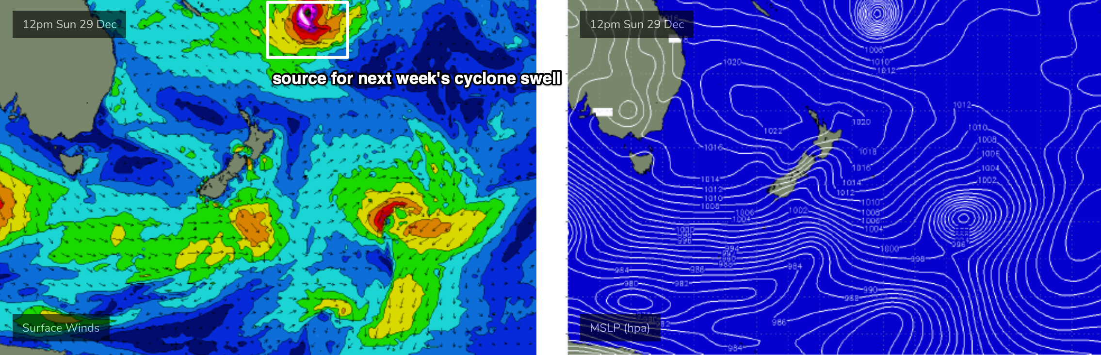
Therefore at this stage I still need to keep the outlook rather broad, but there is a positive - the cyclone is expected to remain slow moving and should meander within the swell window for quite a few days, which should result in a prolonged swell event. Had this beena short lived event, I wouldn't be very interested in it but I think the current (slow) forecast path should override some of the negativities associated with the fetch alignment and large travel distance. Of course, this could change over the coming days so we'll need to keep a close eye on things.
The early forerunners should start to arrive Monday, and we’re looking at an initial peak in size around Wednesday, but we’ll continue to see strong energy through the rest of the week, possibly even holding into the following weekend.
I’m still unsure on how much size we’ll see at the peak of the swell - in Monday’s notes I mentioned 4-6ft which was certainly quite optimistic - and whilst there’s no clear evidence to significantly downgrade (or upgrade) this size range, it’s probably worth pulling back wave heights to about 4-5ft at the height of the swell. Most of the event will see surf size persisting at just under maximum size.
As for conditions - we’re still a long time away, but the second half of the week is looking better than the first half, as the Tasman high moves further to the east, allowing fresh N/NE winds Mon/Tues to recede and become lighter and more variable.
Let’s take another pass at this on Friday.
See you then!
Comments
Merry Xmas Ben - thanks for your insights.
SAM is going positive so assume that the SSW is on the way out?
Only temporarily, forecast to dip back south again, might not be over yet..