Fun waves for the next few days, patchy thereafter

Sydney, Hunter and Illawarra Surf Forecast by Ben Matson (issued Wednesday 2nd October)
Best Days: Thurs/Fri: fun S'ly swell (occasionally sizeable at south swell magnets later Thurs) with generally good winds. Sun: small new S'ly swell but you'll have to work around N'ly winds.
Recap: Tuesday’s Sly swell came in as expected with size building to 3-4ft throughout the day (bigger in the Hunter, smaller elsewhere). Early light variable winds swung moderate NE into the afternoon. Today, surf size has eased back to 3ft at south facing beaches (again, bigger in the Hunter, smaller elsewhere) and winds are light N’ly.
This week (Oct 1 - 4)
No change to the outlook for the next few days.
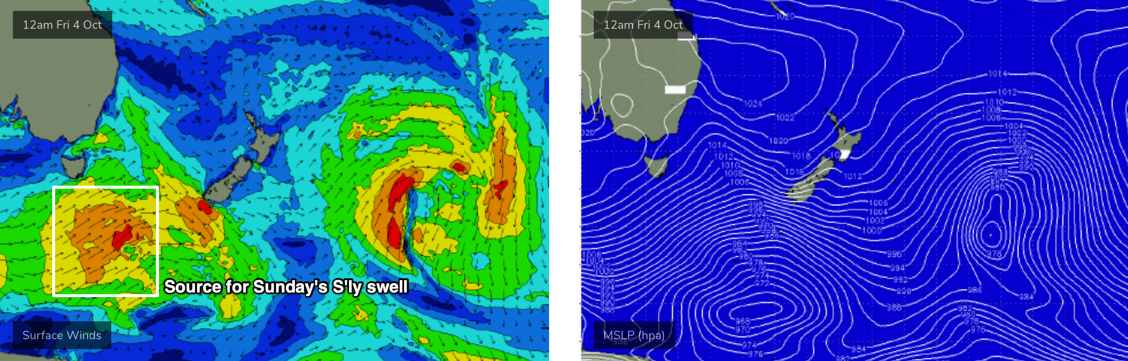
We’re in the middle of a pattern of overlapping southerly swells, of which the swell displaying the longest periods of the week is due to build through Thursday.
However, this swell will have been sourced from a more acute part of our swell window, well below the continent so I’m expecting fewer locations to pick up the bulk size, and it’ll be a lot less consistent too.
Most south facing beaches should rebuild into the 3-4ft range (there may be a brief lag at dawn north from Sydney) but south swell magnets like the Hunter region should pick up 4-6ft+ sets at times - more likely mid-late afternoon. Anywhere not directly exposed to the south will be a lot smaller. And keep in mind that there’ll be less set waves than yesterday’s S’ly swell, it’ll be more flukey in coverage.
Surface conditions are looking pretty good with mainly light winds, probably early NW then maybe NE later but likely under 10kts.
On Friday, we’ll be on the backside of this southerly sequence, so surf size will trend steadily downwards. A shallow trough will approach from the south and we may see a wind change to the S/SE mid afternoon, but the morning should be clean with light variable winds. Expect 3ft sets early at south facing beaches (bigger across the Hunter) but smaller surf elsewhere.
This weekend (Oct 5 - 6)
Friday’s S’ly change may linger across some coasts into Saturday morning - probably just the Hunter - but otherwise it’ll clear to the east and offer light winds for most of the day, and thus improving surface conditions.
Saturday is looking a little slow and lacklustre in the surf department with minor leftover S’ly swells up to 2ft at south facing beaches (3ft in the Hunter) but remaining pretty small at most other beaches.
Another strong front pushing through the lower Tasman Sea on Friday will be less favourably aligned within our swell window that recent storms, but it’ll generate a new S'ly swell for late Saturday (South Coast) and Sunday (remaining coasts). Most south facing beaches should pick up 2-3ft+ sets and the Hunter is likely to nudge 4ft+ at times (though it'll be pretty inconsistent).
However, an advancing front from the south-west will strengthen N’ly winds across the region - probably generating some late NE winds well too. As such you’ll need to find a sheltered northern corner for the best waves.
Next week (Oct 7 onwards)
There’s still nothing of any great significance standing out in next week’s forecast.
A small low will form in the south-western Tasman Sea on Monday but it doesn’t look like it’ll be much a quality swell producer - just some small to moderate, low period S'ly windswell energy for a couple of days with average conditions under accompanying southerly breezes.
Otherwise, a series of Southern Ocean lows migrating below Tasmania will supply small, background long period S’ly energy for most of the week.
Let’s take a closer look on Friday to see if any particular day stands out as being worthwhile.
Comments
“brief lag at dawn” for the south swell tomorrow, any chance it will hit the cenny coast in time for the early?
Quietly hoping for a model/forecast upgrade on Friday for what looks like a pretty average long weekend ahead.
Batemans Bay buoy has the leading edge of the new S'ly swell in at 19 seconds around 8am. Just playing the waiting game for the arvo across Sydney/Hunter coasts.
There were some solid waves coming through down south this morning. It was a bit funky at low tide but cleaned up nicely when it filled in.
How big? You on the Shoalhaven or Sapphire Coast?
Southern Shoalhaven. 4-5ft with the odd bigger one. It was fairly inconsistent at times as you mentioned in the notes.
Northern Beaches slower 2-3ft today, swell hasn't hit yet..
Argh!
Only 2 - maybe 3 Cronulla way. Didnt see anything like 4-5 albo was talking about Shoalhaven way.
Will the little NE swell shown in the models tomorrow morning produce any peaky 2ft+ waves at magnets?
Is gonna be late Ben? Or not at all
So fun out at first light this morning, and next to nobody on it. Epic summer feeling morning!
Looks like the last S'ly swell pulse was late to arrive (or more accurately, the leading edge was on time, but the bulk size/energy was much further behind than expected). Swell periods increased overnight, and the northern end of the Manly stretch is looking fun this morning (with some small NE windswell putting peaks into the straight S'ly swell lines).
Does the late arrival mean we could see it stretch out into next week? Hoping for an upgrade for Tuesdays forecast. Need to cash in on those RDO's.
Unfortunately, an eight hour delay does not equate to a four day extension.