Fluctuating southerly pattern all week

Sydney, Hunter and Illawarra Surf Forecast by Ben Matson (issued Monday 30th September)
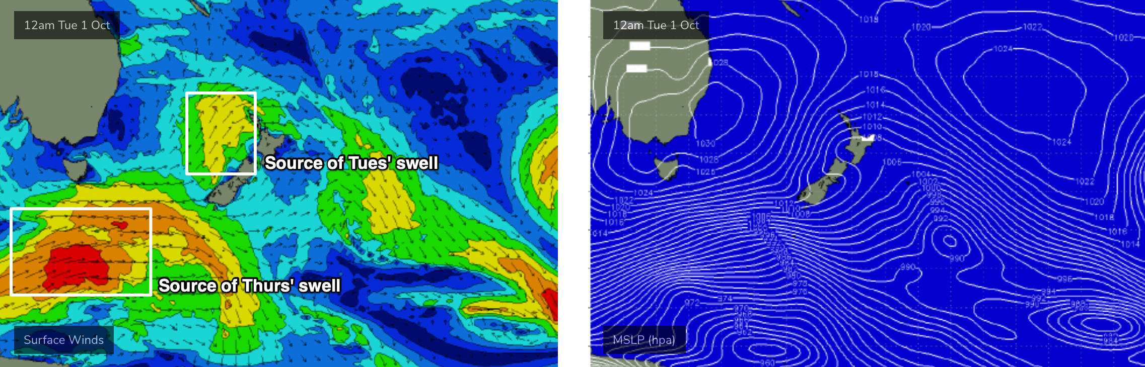
Best Days: All week: plenty of S'ly swell, biggest Thurs. Clean in the mornings with N/NW thru' NW winds, becoming bumpy into the a'noons.
Recap: Saturday delivered generally poor surf with strengthening southerly winds and slowly building S’ly swells, though the Hunter delivered an hour or two of temporarily clean conditions ahead of the change (which arrived a little later than expected, just before dawn in Sydney). Sunday provided great waves with light offshore winds and slowly easing S’ly swells form 3ft+ at south facing beaches. Today has dawned much smaller with light variable tending onshore winds. The first in a series of new S’ly swells is due into the coast late afternoon.
This week (Oct 1 - 4)
We’ve got a succession of new S’ly swells inbound for the rest of the week, and the good news is that there’ll be reasonably favourable conditions most days.
A high pressure system will remain anchored across the western Tasman Sea, and it’ll swing the winds around to the north, though without a lot of strength. In fact, most mornings should see periods of N/NW maybe even NW winds, then it’ll trend N’ly then N/NE as the days progress.
As for surf, there are two primary southerly swells to work around, though we’ll actually see four or five individual pulses between now and Friday, and so the overlapping swell trains will create some interesting setups across exposed south facing beaches. Because of this, estimating precise daily size trends is difficult, so as per Friday’s notes I’d prefer to ballpark the two main peaks and the likely timing where they’ll reach maximum size.
Tuesday and Thursday will see the biggest waves of the week; the first swell on Tuesday should reach 3-4ft+ at south facing beaches (4-5ft+ across the Hunter), though it’ll be smaller at beaches not completely open to the south. This swell will have been generated by the front pushing through the Lower Tasman Sea this morning (and we may see an upwards trend later this afternoon, more so on the South Coast).
Wednesday will see a minor decrease in size - not a lot, mind - ahead of a long period S’ly swell on Thursday, sourced from a powerful low beneath the continent at the moment. It’s very strong but poorly aligned, so I’m expecting a fraction more size at south swell magnets but probably a broader range in wave heights - i.e. a smaller percentage of locations picking up the bigger surf, and proportionally smaller surf at protected spots.
So, south facing beaches should rebuild to 3-4ft+ through the day but south swell magnets like the Hunter should push 4-6ft+ at times (we may see a brief lag in size at dawn). Set waves will also be a lot less consistent. And it'll be much smaller at beaches not open to the south.
Steadily easing wave heights are then expected on Friday with similar conditions.
This weekend (Oct 5 - 6)
Another front taking this well-worn synoptic path (of recent weeks) will enter the lower south-eastern Tasman Sea on Friday, and generate a new S/SE swell for late Saturday (South Coast) and Sunday (Sydney/Hunter et al).
At this stage it’ll probably fall shorter than our south swells earlier in the week, perhaps some very inconsistent 2-3ft sets at south facing beaches and up to 3-4ft in the Hunter, though again smaller elsewhere not open to the south.
Freshening northerly winds will accompany the upwards phase and peak of this swell, so sheltered northern corners are likely to provide the only limited surf options this weekend. Saturday will be clean early morning but very small with minor leftover S’ly swell.
Next week (Oct 7 onwards)
Nothing major standing out for next week other than the normal spring-time progression of fronts through the Tasman Sea, maintaining some kind of southerly swell for the foreseeable future. More on this in Wednesday’s update.
Comments
Good one.
Ben we are currently running a SSE wind. Do you think that’ll turn northerly overnight ?
I reckon it will be light ESE by the morning.
For me it looks variable/calm W, starting to come up from the E/NE-NE by midday.
Cheers boys. Am hoping for anything with a N handle