Benign week of waves ahead, though there are small options

Sydney, Hunter and Illawarra Surf Forecast by Ben Matson (issued Monday 22nd July)
Best Days: Nothing great this week, but Tuesday and early Thursday have potential for fun small waves. Wednesday will see building surf after lunch but with freshening S'ly winds.
Recap: Saturday delivered great waves with light winds and 3ft of leftover S’ly swell across most regions, up to 4ft in the Hunter. Size eased steadily into Sunday and today we’ve seen tiny leftovers across most coasts.
This week (July 23 - 26)
Today’s Forecaster Notes are brought to you by Rip Curl
There’s not a lot of favourable storm activity inside our swell windows this week. We’ve got an amplifying node of the Long Wave Trough over WA and SA right now, and the downward flank across the Tasman Sea is steering cold fronts to the south, away from our region.
We do have a couple of small swell sources though.
As Craig mentioned on Friday, a small SE swell will filter through on Tuesday, thanks to a brief fetch of poorly aligned S’ly winds off the SW tip of New Zealand yesterday. The models aren’t picking up this swell very well, but I still think there’s a chance for inconsistent 2ft sets across exposed beaches, up to 2-3ft across the Hunter, but with long breaks between waves. It’s not a swell event to work around, bur fortunately it’ll be clean with moderate W/NW winds.
The only other swell source this week is a modest front pushing through eastern Bass Strait overnight Tuesday and into the early hours of Wednesday morning (see below).
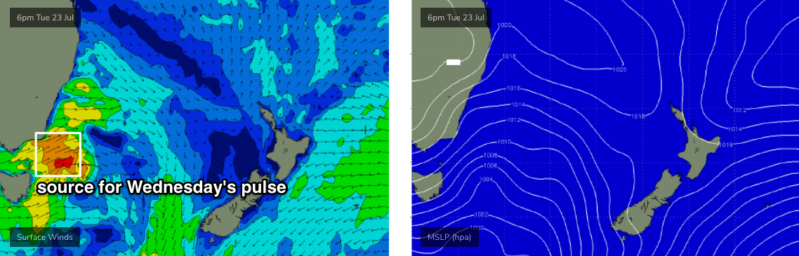
It’ll drive strong SW winds adjacent to the Southern NSW coast through the morning, and build a small S’ly swell for the afternoon (smaller through the morning), perhaps reaching 2ft+ at south swell magnets towards dark, up to 3ft+ in the Hunter. Early W/NW winds will swing to the S/SW and freshen as the swell builds after lunch, which is unfortunate, so keep your expectations low for any major quality from this phase of the swell.
A slow easing trend is expected from Thursday morning onwards, and early light offshore winds will produce small peaky sets at south facing beaches for the dawn patrol, somewhere between 2ft and 3ft (the upper end of this size range across the Hunter region). Elsewhere, beaches with less southerly exposure will be tiny, and we’ll see surf size ease steadily into the afternoon, bottoming out on Friday with very small leftovers at south facing beaches under a moderate offshore breeze as a weak front approaches from the south.
So, keep an eye out for stray sets out of the SE on Tuesday, don’t worry too much about Wednesday’s building trend, and perhaps aim for an early session Thursday at your favourite south swell magnet.
This weekend (July 27 - 28)
It's looking like a very small weekend of waves ahead, with minimal swell generating activity expected to develop later this week.
The only areas to keep a watch out for in subsequent model updates are the remnants of our mid-week Tasman front, which is expected to form a weak low off the West Coast of New Zealand. At this stage it doesn’t look conducive for any major size, but it will be slow moving and that’s a positive.
Otherwise, a series of weak fronts will push through the lower Tasman Sea from Friday night through Saturday, and although they look a little lifeless on the charts right now, there is always potential for an upgrade.
So, don’t get too bothered by the lack of activity on the charts - there’s a few possibilities in store.
Next week (July 29 onwards)
There’s nothing of major interest showing across the long term charts right now.. .. but that will change over the coming days, so let’s wait and see what Wednesday brings.
Comments
when are the off line cameras back on ? It,s been a while...…...
Heading down next week to sort 'em all out. Got the last of our new NBN connections slated to be switch on around Thursday.. fingers crossed.
Actually, I didn't mention it in these notes, but there's some fascinating E'ly swell developing for northern regions (detailed in SE Qld notes, here), and there's certainly a chance that we may see this filter down into Southern NSW too (though much, much smaller in size). it's too flukey and far away to be confident so I'll detail it in Wednesday's update, depending on how the models trend.
Sent a mate who loves just North of Gisborne a msg around that system last week - still haven’t heard back from him... had a nice squeeze on it.