An end to small settled conditions; large, windy south swells ahead

Sydney, Hunter and Illawarra Surf Forecast by Ben Matson (issued Friday 24th May)
Best Days: Late Sun and (more likely) Mon: small E/NE and S'ly swell combo. Late Mon/Tues: solid S'ly swell. Thurs/Fri/Sat: large S'ly swell, potentially very large.
Recap: It's been very small for the last few days with minor residual energy across most coasts and clean conditions with light winds.
This weekend (May 25 - 26)
Today’s Forecaster Notes are brought to you by Rip Curl
Most of the weekend will remain very small.
The models are suggesting a series of long period S’ly swells will glance exposed south swell magnets, but I don’t think we’ll see much in it. In general, most beaches will see tiny waves of barely one foot or less, but it’s plausible that south swell magnets may see the odd stray bigger set. Light offshore winds will keep conditions clean. Keep your expectations low.
On Sunday, the leading edge of a small new E/NE swell will make landfall, building size from 1ft to 2ft throughout the day, ahead of a peak in size on Monday. This swell was generated by a broad though ultimately moderate-strength trough/E'ly dip south of Fiji yesterday and today, that would ordinarily be ignored - had our near swell windows shown any signs of activity.
Set waves will be very inconsistent but with favourably light winds there may be just enough energy for an afternoon session across the wide open beaches, more likely into the afternoon.
Next week (May 27 onwards)
Sunday’s new E/NE swell should hold through Monday with very inconsistent sets somewhere between 2ft to maybe 2-3ft. Conditions will be clean though blustery with freshening E/NE tending W/SW winds as a strong cold front clips the southern part of the state.
Gale-force W/SW winds exiting eastern Bass Strait later Sunday and into Monday will project through the western Tasman Sea and align more SW off Southern NSW, and generate a short lived though punchy S’ly swell.
This is a better synoptic projection than Wednesday’s forecast was expecting (to be honest, it’s more inline with last Monday’s outlook!), and after a small start, we should see a rapid increase in size through Monday afternoon, reaching 4-5ft+ at south facing beaches on dark, plateauing in size into Tuesday morning before easing steadily during the day and bottoming right out into Wednesday. I'm not super confident on the timing of the upwards trend (on Monday) so I'll update in the comments below as new data comes to hand.
As per usual, beaches not open to the south will be much smaller. We’ll see great conditions both days with moderate offshore winds, and there’ll be a small undercurrent of E/NE swell in the mix from the remnant tropical system responsible for the late Sun/Mon swell (though, no major size is likely).
Looking further ahead, and a very significant node of the Long Wave Trough is expected to amplify into the Bight early next week, generating very large waves for SA, Vic and some Tasmanian coasts.
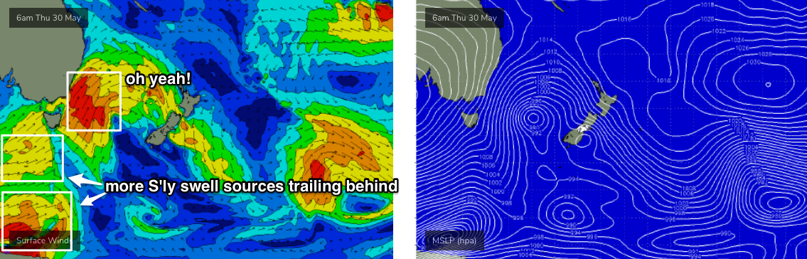
Although the mature phase of this event will generally occur inside the Tasmanian swell shadow (relative to NSW’s swell window), we’ll see a powerful secondary phase push through the lower Tasman Sea mid-week (see chart below), generating large southerly swells for Thursday and Friday. The latest models are looking pretty good, with a much stronger, more favourable alignment compared to the last few days and subsequently wave heights have been revised upwards. In fact we could be looking at two or three days of very large surf.
Wednesday stands an outside chance at seeing a small increase in southerly swell spread from westerly gales exiting eastern Bass Strait, but Thursday and particularly Friday will see the most energy, with south facing beaches likely to push upwards of 8ft or more at the height of the event. Winds are likely to remain broadly SW for the duration of this event but we’ll see periods of W/SW winds at times. I also can’t rule out much bigger surf at offshore bombies and south swell magnets either (though, beaches not open to the south will be much smaller).
Further fronts trailing behind will maintain this active phase of strong south swell into the weekend too.
Therefore, it’s certainly shaping up for an active time frame ahead, so despite the weekend’s small waves, it’ll be worth a couple of fitness paddles to keep on top of things in preparation for some sizeable action later next week.
See you Monday!
Comments
Hoping for a bank buster at the local. Those ruler edge banks only deliver close outs.