Small E/NE swells for the short term; solid from the south next week

Sydney, Hunter and Illawarra Surf Forecast by Ben Matson (issued Wednesday 20th March)
Best Days: Most days: small mix of E/NE swells with mainly light winds. Tues onwards: strong S'ly swells. Next Thurs onwards: slowly building E/NE swells.
Recap: It’s been pretty small for the last two days, though there’s been two distinct swell trains in the water - a small E’ly swell and a very infrequent but long period S’ly groundswell that produced swell periods in the 15-17 second range across various parts of the East Coast. Wave heights have been around 2ft though the S'ly swell did produce periods of 2-3ft waves at outh facing beaches. Winds have been generally light so conditions have been reasonably clean.
This week (Mar 19 - 22)
Today’s Forecaster Notes are brought to you by Rip Curl
*this week's Forecaster Notes will be occasionally brief and erratic, as Craig is on annual leave - to receive notification when they’re updated, please update your account preferences*
Our swell windows are devoid of any major synoptic activity, and with our recent glancing southerly swell now exiting to the north, we have to look towards peripheral swell sources for the short term.
A broad trough occupies the western Tasman Sea, and a developing NE infeed into its eastern flank today will generate some sideband E/NE swell for Thursday afternoon and Friday. This fetch is better aimed towards Tasmania, but we should see some useful surf rebuild back up into the 2ft+ range (wave heights may be a little undersized early Thursday). It'll be pretty slow and inconsistent though, as it's off-axis from our swell window.
A small southerly fetch developing across the SW flank of the Tasman trough on Thursday may generate a small S’ly swell for Friday but I don’t think there’ll be much in it.
Mainly light winds are expected both days, mainly out of the south if anything (light offshores each morning too).
This weekend (Mar 23 - 24)
Light winds are on track for Saturday morning ahead of a freshening NE breeze into the afternoon as a small trough moves across the South Coast. We’re likely to see light and variable winds return on Sunday as the trough occupies the Sydney region.
As for surf, there won’t be much on offer, just a mix of Friday’s mid-range E/NE swell from the Tasman trough, plus a similar level of small, long range (though ultimately moderate-period) E/NE swell from a lengthy fetch way out NE of New Zealand over the weekend.
Expect slow, inconsistent 2ft+ sets at exposed beaches at best, with long periods of very small conditios between the bigger waves. Model guidance has Sunday punching a little higher than Saturday but there won’t be much in it. Sunday morning may also have a small degree of NE windswell from Saturday’s late breeze.
Next week (Mar 25 onwards)
A vigorous series of fronts and lows will cross the SE corner of the country early next week, delivering winteresque wintery gales to the Far South Coast, but probably not affecting Sydney, Hunter and Illawarra quite as much (though a period of gusty S’ly winds are likely around Tuesday).
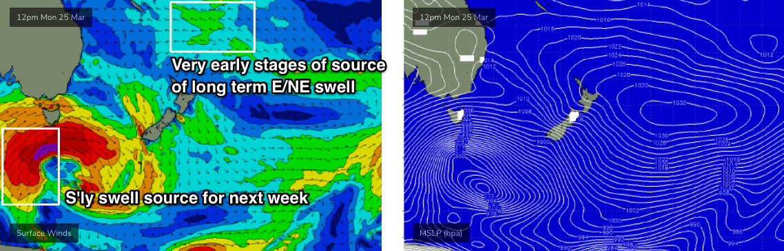
Initially, this system will be poorly aligned for our coast - mainly behind the swell shadow of Tasmania - but Monday morning should see W/SW gales exiting eastern Bass Strait (been a while, eh?) that’ll generate fresh southerly swells by possibly late afternoon, but more likely Tuesday.
Unfortunately, Tuesday looks like it’ll be accompanied by gusty SW tending S’ly winds as a front moves up the coast, but this won’t last long and we’ll see steadily improving conditions from Wednesday onwards.
And this is around the same time we’ll see building S’ly groundswells from the parent low, tracking below Tasmania later Monday and early Tuesday. It still looks like it’ll be poorly aligned but we should pick up 4-5ft sets at most south facing beaches on Wednesday, with the associated long periods (16-18 seconds) originating from 50kt core winds (see below) likely to further enhance wave heights at offshore bombies and reliable swell magnets (6ft+). it'll be much smaller at beaches not open to the south though.
Looking beyond this and there’s plenty of surf in store for the longer term period. Secondary fronts travelling through the lower Tasman Sea will generate more S’ly swell for the second half of next week, and a developing tropical system near Fiji and Tonga early next week looks like it’ll evolve into a favourable E/NE swell machine by mid-late week, resulting in an initially small, slow upwards trend around Thurs/Fri, ahead of a better quality groundswell through the weekend and into the start of the following week.
More on that in Friday’s notes.
Comments
please please let autumn swells begin!
Off next week. Melbourne for Sunday Monday then south coast NSW all next week. I like the sounds of this especially Wednesday onwards