Solid south swell Thursday; complex outlook beyond

Sydney, Hunter and Illawarra Surf Forecast by Ben Matson (issued Wednesday 26th September)
Best Days: Thurs: solid long period S'ly swell, good winds until mid-late morning. Sun: peaky mix of swells with light winds.
Recap: There’s been plenty of fun south swell over the last few days, easing from 3-4ft Tuesday to 3ft this morning, and becoming a little smaller throughout today. Winds have been generally light so the surf’s been reasonably clean though periods of light to moderate onshores have created wobbly conditions at times. As yet there’s no new signs of the new long period S’ly swell due to arrive later today and peak through tomorrow.
This week (Sep 27 - 28)
Today’s Forecaster Notes are brought to you by Rip Curl
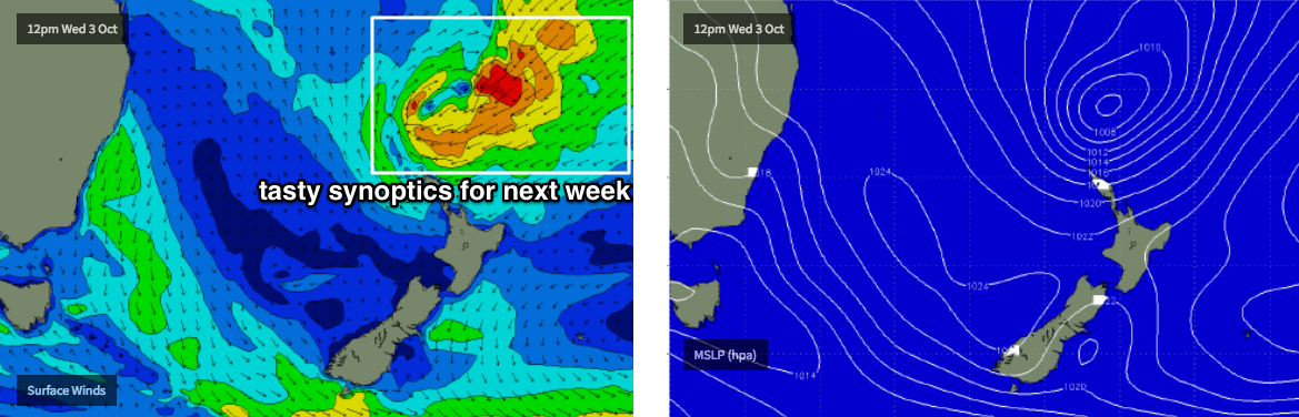
A new long period southerly swell will push through overnight and is expected to peak through Thursday. This swell was generated by an impressive polar low that pushed towards New Zealand late Monday and Tuesday. Although not perfectly aligned within our swell window, it displayed a broad, lengthy and sustained fetch and was working on an active sea state.
Wave heights should increase to 4-6ft at south facing beaches through Thursday, however the bigger waves will be rather inconsistent at times owing to the poor fetch alignment. On the other hand, the large swell periods associated with this event should boost surf size at offshore bombies and other reliable south swell magnets (i.e. the Hunter coast) into the 6-8ft range at times. Beaches not exposed to the south will be considerably smaller.
A peak in size is expected around the middle of the day, with easing swells into the afternoon. The morning will also offer the best conditions with light offshore winds, before they swing northerly mid-late morning and then freshen from the NE from lunchtime onwards. So, aim for an early session for the best waves.
Friday’s dynamics have changed since Monday’s notes were written.
An advancing trough will push up a southerly change for Friday night, and ahead of it we’ll see freshening N/NE winds. There’s a chance for an early period of lighter N/NW winds in the morning, but it won’t be perfectly clean and is likely to deteriorate throughout the day as the N/NE breeze resumer (the S’ly probably won’t reach the South Coast until mid-late afternoon).
As for surf, we’ll see a mix of easing S/SE groundswell (3ft+ south facing beaches early, easing to 2ft throughout the day) plus some peaky NE windswell in the 2ft+ range at reliable NE swell magnets. Overall, keep your expectations low but there may be the odd window across the region if you’re in the right place at the right time.
This weekend (Sep 29 - 30)
Friday’s late change will develop a decent fetch in its wake, and this will generate some fresh south swell for Saturday, probably around 3-4ft at south facing beaches, slightly bigger across the Hunter but smaller elsewhere.
However, winds will remain from the S/SW so most locations picking up the size will be wind affected. We should see a window of lighter W/SW winds early morning at one or two coasts (such as the Northern Beaches) but with the NE windswell almost gone by this time, there won’t be a lot to get excited about.
Sunday looks a little better on the surface with easing winds tending W/SW through the morning then light to moderate S’ly throughout the day.
Saturday’s short range south swell will be gone but a smaller S’ly groundswell will replace it, generated by strong though poorly aligned fronts south of Tasmania on Friday. This should maintain 3ft sets at south facing beaches, though it’ll be smaller at beaches not open to the south. The Hunter should see larger waves around the 4ft mark though.
Next week (Oct 1 onwards)
Nothing amazing to look for, but a couple of points that I’ll address in more details on Friday’s notes. They are:
1. The remnants of Saturday’s trough will linger in the central/northern Tasman Sea from Sunday afternoon onwards and may generate some small sideband E’ly swell early next week
2. A series of intense Southern Ocean fronts south of Tasmania will be poorly aligned (again!) for our coast but their strength is impressive, and we can’t rule out some spread back up the NSW coast - right through next week, with the most size potential mid-late week.
3. A tropical cyclone may form near the Solomon Islands tomorrow, though it won’t be well positioned for us.
4. Moderate trades in and around the Fijian region from the weekend onwards look like they could become part of a deepening surface-trough-cum-subtropical low (see below), and in turn a more substantial though distant groundswell source through the middle to latter part of next week, providing E/NE swell for the end of next week and (more likely) the following weekend.
Comments
Are the broken surf cams going to be fixed?
Yeah, we've had a few go down in the last week or so, which is unfortunate. We thought Maroubra was an ISP outage (ADSL services across the Randwick area were offline from Wed AM thru' Thurs PM) but the surfcam hasn't come back today so we'll send a technician down ASAP to investigate. Cronulla Point went down last week, and will be replaced ASAP - though we're changing the camera type there which means a different mounting bracket, and thus a tricker swapover (otherwise it'd have been done ASAP). Bondi and our Illawarra cams are (still!) awaiting final sign off by the relevant authorities - it's taken way longer than expected, but unfortunately is out of our hands. However they've all been given in-principle approval so it's merely red tape to overcome. I guarantee it'll be worth the wait though.. the new locations are amazing.
Ok, fair enough. Im excited for the new ones!
Thanks