Tricky week ahead, best Wednesday with a NE windswell

Sydney, Hunter and Illawarra Surf Forecast by Ben Matson (issued Monday 18th December)
Best Days: Wed: peaky NE swell with early NW winds. Fri/Sat: flukey long priod S'ly swells, small though worthwhile at swell magnets.
Recap: Slowly easing E/NE and NE swells maintained fun waves over the weekend, before dropping a little more today.
Today’s Forecaster Notes are brought to you by Rip Curl
This week (Dec 18th onwards)
Just a quick summary for the forecast period today, as I’m on the road at the moment - apologies (short notes again Wednesday; back on deck properly Friday).
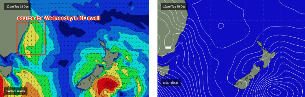
Freshening NE winds Tuesday will write off local conditions but build a NE windswell into the afternoon that’ll peak early Wednesday with sets around the 3ft+ mark at NE facing beaches, perhaps even a few bigger bombs at reliable swell magnets. A trough will cross the coast in the morning, swinging winds to a light NW. So it’ll be reasonably clean on top.
Wednesday is certainly the pick of the forecast period, though wave heights will be smaller at south facing beaches and through the Northern Hunter.
A shallow S’ly change early Thursday will deliver poor conditions but the parent low and a series of trailing front (all tracking south of Tasmania) from Wednesday onwards will generate inconsistent, very poorly aligned but long period S’ly groundswell for Friday (2ft+) and then Saturday (3ft+), exclusive to south swell magnets (mainly the Hunter). Don’t expect much elsewhere.
Winds on Friday and Saturday will ease and thus improve conditions though we’ll see a persistent onshore flow, enough to put a long term wobble through the lineup. Most beaches will see a residual mix of average quality surf, not worth working around to be honest.
Long term outlook maintains some interesting tropical developments out near Fiji but of much more important is an unstable trough off the Southern NSW Coast from Sunday onwards that should evolve into a solid local swell generating system early next week. More on this in Wednesday’s notes.