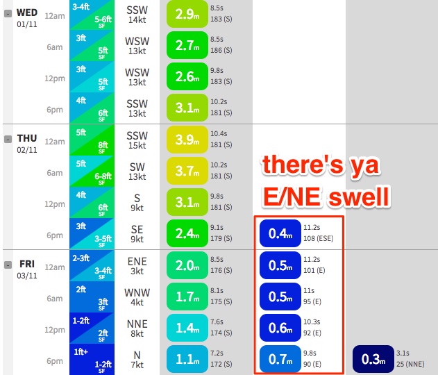
Three days of solid south swell; then a fun E/NE swell Friday onwards

Sydney, Hunter and Illawarra Surf Forecast by Ben Matson (issued Monday 30th October)
Best Days: Wed: solid S'ly swell with morning offshore winds. Thurs: rapidly improving conditions as winds swing light offshore, and a large S'ly swell, easing during the day. Fri: great mix of easing S'ly and peaking E/NE swell with light winds. Sat: smaller but steady surf from the E/NE with freshening S/SW winds, getting better Sun as winds become light again.
Recap: A fun SE swell provided good waves over the weekend, with peaky sets around the 3ft mark for most of Saturday, even holding out across a few locations early Sunday, before it eased rapidly through the morning and into the afternoon. Today we’re left with a tiny mix of leftover SE swell and minor NE windswell.
This week and weekend (Oct 26 onwards)
*today’s notes will be brief as Craig’s away*
There’s no real change to the notes issued Friday, except a little more fine tuning on size and timing for each incoming swell this week.
It’s worth pointing out that over the weekend, the models have moved around a lot regarding the upcoming Tasman Low - but seem to have settled this morning with a similar solution as per Friday’s run.
So, the upshot is for three days of solid south swell. Tuesday will initially see low/medium quality short range swell in the wake of a gusty change expected later today. South facing beaches should reach 4-5ft+, bigger across the Hunter but smaller elsewhere. Protected corners will be much smaller though cleaner under a fresh S/SW breeze (may tend SW in a few locations, though not many).
Wednesday’s still on track for a better quality mid range swell - probably a similar size as per Tuesday - but with much better conditions as a slingshotting front around the new Tasman Low temporarily steers winds to the W/SW through the morning and lunchtime period. Winds will swing gusty SW then S/SW across the South Coast around early-mid afternoon though the timing on this for the Sydney region is unclear (may not happen until dinner time).
Thursday should then pick up the peak size from the Tasman Low, with easy 6ft+ sets across south facing beaches, bigger around 6-8ft+ across offshore bombies and the northern Hunter. In fact, we could see bigger waves than this depending on how strong winds get around the low (being positioned this close to the mainland means wind strength errors have a slightly greater effect on eventual surf size). There may be a lingering SW breeze across many beaches but we’ll see a rapid improvement throughout the day as winds veer more W/SW (then variable into the afternoon). Size will also ease into the afternoon.
This swell will ease rapidly through Friday, down to 3ft+ south facing beaches early morning (bigger in the Hunter), then smaller later. Light variable winds will keep conditions clean.
And let’s not forget our incoming E/NE swell!
A minor increase is expected through Wednesday, and the leading edge of the main pulse is due sometime later Thursday (though you won’t be able to see it either of those days due to the dominant S’ly swell) but as it builds through Friday we’ll see peaky 3ft+ sets at open beaches, easing slightly but steadying in the 2-3ft range for Saturday and probably Sunday, though becoming less consistent. A S’ly change is expected Saturday with light winds due Sunday.
Next week has more strong fronts due the through the lower Tasman Sea, though we’ll also see a small undercurrent of long range E/NE swell from the current stationary high east of New Zealand for a couple of days at least.
Comments
Hi Ben and Craig,
do you have any further ideas on what the winds will be up to south of Sydney on Thursday afternoon at 1?
Cheers
Eh? A precise wind forecast for a specific time, for a broad stretch of coast?
ok, good point.
how about around low tide in the Illawarra?
Google: "BOM Meteye". Have a crack at their animated wind forecast for your region. Not 100% accurate, but better to be fairly empowered right? It's a fun little page actually.
Cheers BP, I'm on bom, seabreaze and the array of sites (mostly sw), but I'm just trying to reconcile the sw forecast notes indicating winds tending W/sw on Thursday arvo when everything else is saying se winds.
I'm really hoping ben is right so my selfish behaviour is worth it. :) Priorities.. Surfing can be such a selfish pursuit.
Decent lines at Shark Island this AM.
some solid sets coming through now. messy and building.