Strong south swell for Sydney, plus a rare funky NE and some tidy E/NE swell

Sydney, Hunter and Illawarra Surf Forecast by Ben Matson (issued Monday 8th May)
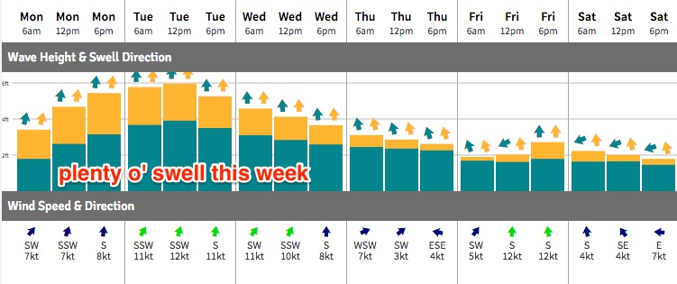
Best Days: Tues/Wed/Thurs: plenty of south swell with good winds early (all day Thurs). Minor NE swell may appear Wed at a handful of spots. Late Thurs/early Fri: fun E/NE swell with good winds.
Recap: Friday’s south swell eased rapidly into Saturday leaving 1-2ft waves for the morning session and not a lot into the afternoon. Sunday remained smaller for the most part across the Sydney region, but in the hour or so before dark a brief flush of south swell pushed along the coast, generated by a strong W/SW fetch exiting eastern Bass Strait earlier that morning. This swell eased back a little for the early session this morning but is now building steadily as a larger south swell pushes across the region in response to a new Tasman Low that formed east of Tasmania last night.
This week (May 9 - 12)
Today's new south swell has built a little more slowly than Friday’s notes anticipated, but I’m not revising my forecast size from this event - a couple of hours off in the timing department isn’t too bad at three days notice.
The Tasman Low has wound up nicely east of Tasmania, and the latest modern guidance has come back in line with a slightly more prolonged swell event from this system, meandering the low about the Southern Tasman Sea up until Thursday. However, this system has already reached peak intensity, so even though it’ll remain within a good region of our S and SE swell window for the next few days, the largest surf we’ll see will be overnight tonight and early Tuesday, with smaller (but still strong) surf padding out Wednesday, easing further into Thursday.
Tuesday morning’s looking at 5-6ft sets at south facing beaches, with bigger bombs across the Hunter, easing to 4-5ft Wednesday morning and then 3-4ft by the afternoon. We may still see some 3-4ft sets early Thursday but it’ll be back to 2-3ft by the afternoon, and smaller waves will then pad out the coast into Friday.
As usual, expect smaller surf at locations not completely open to the south but each and every day could see bigger sets across the Hunter.
In Friday’s notes I mentioned STC Donna - developing near Vanuatu - which had the potential to generate an interesting, unusually long period NE groundswell for the East Coast.
Over the weekend STC Donna reached Cat 4 strength, and then Cat 5 this morning, though it is now located well and truly inside the swell shadow of New Caledonia.
However STC Donna did briefly skirt the southern periphery of a very narrow, rare swell window just north of New Caledonia. It’s still hard to be overly confident in a decent swell event anywhere from this system, but I’m remaining steady with expectations for a very solid cyclone event in SE Qld on Tuesday and maybe early Wednesday.
However size will diminish with increasing southerly latitude south of Byron Bay; not just due to the extra travel distance but also because the anticipated swell window was really only open to northern regions. Our model is picking up a small long period NE swell across the Sydney region (i.e. Northern Beaches data point) from late Tuesday (leading edge of 0.5m at 15.1 seconds) plateauing into Wednesday (0.6m at 14.3 seconds), but in all reality most of this swell will bypass the Southern NSW coast due to the narrow swell window and slight shadowing offered by the Hunter curve.
That being said, I can’t rule out the possibility of a handful of well exposed swell magnets picking up some fun waves the 2-3ft range. The difficulty late Tuesday and (more likely) Wednesday is that it’ll be extremely hard to decipher the extremely inconsistent NE groundswell from the dominant, much more consistent south swell. Especially as must beaches are likely to dip out owing to the funky swell source. Almost all of this unusual NE swell will be gone by Thursday morning.
But here’s another complexity to add into the equation: ex-STC Donna (by Tuesday) is expected to have tracked SE of New Caledonia, with a broad fetch of trades stretching back out past Fiji. This will generate a secondary E/NE swell arriving locally late Thursday and Friday (in fact, we’ll see a small undercurrent of E/NE trade swell all week from the supporting ridge, in the 1-2ft range).
This should kick up most open beaches into the 2-3ft+ range sometime late Thursday and into Friday, with super fun waves expected across many beaches - though there will be very long breaks between the sets. Our model has the south swell as the dominant swell train by this time but in reality I think the E/NE swell may end up on top at many beaches. Though it won't be very consistent.
Anyway, local conditions look quite manageable for much of the week - mainly moderate S/SW winds, with periods of W/SW thru’ SW winds early mornings. Thursday should see all-day offshores as the low contracts and moves into the Tasman Sea, however Friday afternoon may see a renewal of moderate fresh southerly winds as a new front sweeps up the coast. A new south swell will build in the wake of this change late afternoon, but no great size is expected.
This weekend (May 13 - 14)
We’ve got great conditions ahead for the weekend but no new swell sources. The small increase in S’ly swell late Friday (2-3ft south facing beaches, slightly bigger in the Hunter) will ease slowly from Saturday morning onwards.
Similarly, the E/NE swell seen on Friday will also ease back over the weekend but a steady trade flow further east from ex-TC Donna through the end of the week should maintain inconsistent 2ft+ sets across Southern NSW on Saturday, easing a little into Sunday.
Light variable winds are expected both days. Let’s fine tune in more detail on Wednesday.
Next week (May 15 onwards)
The synoptics look devoid of activity next week! Which doesn’t mean there won’t be any swell.. it’s not uncommon for model runs heavily laden with cyclone activity at the front end to see little (modelled) activity at the back end.
I suspect we’ll see a few swell sources appearing for next week by Wednesday, so let’s take a closer look then.
Comments
Big variations in wave height this morning across the Northern Beaches.
Also you can see the S/SW in the direction when looking at the differences in height between the inshore Port Botany buoy and 10km offshore Sydney buoy.
Port Botany is around 2.3m @ 13s, while Sydney is seeing 3.2 @ 13s.
Manly is an inconsistent 2ft with the odd 3ft bomb, but my mate checked Longy Bommie and saw an 8-10ft set while rocking up. Not sure if could of been bigger as he didn't hang around. He surfed NN and said it was solid 4-5ft.
Agreed, same situation up here on the Central Coast, some places firing, some maxing and others not getting as much swell as expected due to the west in the swell.