Stacks of inbound surf from the E/NE

Sydney, Hunter and Illawarra Surf Forecast by Ben Matson (issued Monday 13th March)
Best Days: Most days should have good waves throughout the forecast period, though onshores are a risk, esp Tues/Wed. Thursday will probably see the best surf with a peak in size and a drop in local wind. Fun surf this weekend too.
Recap: Saturday delivered large, perfect surf across most of Southern NSW with light offshore winds and a thumping east swell around the 6ft mark, with a few bigger bombs reported at times. Size eased to around 4ft on Sunday with NE winds freshening throughout the day, and a further drop to 2ft today. However today we’ve also see a building NE swell thanks to yesterday’s winds, in fact the quality of this shorty range swell belies its local origin - NE facing beaches are picking up solid 3ft sets and although winds have been onshore, we have seen periods of light variable winds at times and therefore clean surface conditions.
This week (Mar 14th - 17th)
There’s nothing I love more than a relatively stationary synoptic pattern. Slow moving weather systems - even small, weaker patterns - always have their swell potential amplified and often result in a much more drawn out event, which increases the chances of finding favourable windows of opportunity.
And that’s what we’re looking at this week.
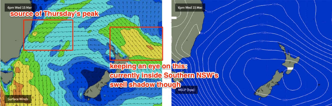
A slow moving trough of low pressure over the eastern states is expected to slow intensify over the coming days, assisted by a stationary high pressure system off New Zealand’s West Coast. Strengthening E/NE tending NE winds aimed straight into Southern NSW’s short range swell window will build wave heights throughout Tuesday and Wednesday ahead of a peak in size on Thursday.
The trough will push offshore during Thursday which will temporarily cease swell production, and result in a drop in size for Friday though there’s likely to be enough residual energy for some reasonable waves to finish the week.
As for size, we’re looking at surf size holding 2-3ft at NE facing beaches through Tuesday, increasing to 3-4ft on Wednesday with a few bigger waves through the afternoon, and then maintaining 3-5ft surf through Thursday. Size will pull back on Friday morning to 2-3ft+ with a further slight easing trend during the day.
Also, keep in mind that surf size will be a little smaller at south facing beaches all week (though not quite as much as if it were a short range NE swell).
There is a risk of onshore winds all week as this system develops, however we may see small pockets of lighter winds in and around low micro scale weather systems. In general though expect moderate to fresh NE winds to prevail Tuesday and Wednesday, with Thursday likely to see a much greater percentage of the day under a light variable flow as the trough moves off the coast.
In fact, the models are suggesting we’ll see a brief return southerly flow on Friday (though I wouldn’t give it much credibility right now, it’s a very small, localised fetch that will be greatly at the mercy of updated model runs).
Anyway, there’s a stack of short range swell on the way so the key to finding good surf will be to look for windows of light winds. Later in the week does look better than the middle, but there could certainly be options if you’re on your toes.
This weekend (Mar 18th - 19th)
Building high pressure in the Tasman Sea on Friday will dissipate the coastal trough and realign a ridge through the Northern Tasman into Northern NSW and SE Qld coasts. We’ll also see a couple of interesting features in this neck of the woods, namely a series of easterly dips that will provide plenty of strong surf (and wind, and rain) for locations north of Yamba.
This means we’re looking at a smaller spread of trade swell across Southern NSW this weekend, but without the gusty onshores. Most beaches should pick up 2-3ft E/NE swell both days, and depending on what Friday’s modelled southerly fetch eventuates as, we could also see some initial lingering south swell (though confidence is much lower for this, than the trade swell).
Winds will hold from the east/northeast both days but at this stage no major strength is expected so on the balance we’re looking at some fun lumpy summery surf this weekend.
As a side note, I’ll also be keeping an eye on a modelled system just NE of New Zealand later this week. Current guidance has it sitting too far inside the swell shadow for Southern NSW but a small shift could swing things in our favour very easily.
Next week (Mar 20th onwards)
Looks like a continuation of a large Tasman high next week and persistent spread of small E/NE swell from a ridge aimed into northern coasts through the first half of the week.
The models are suggesting a series of strong fronts/lows through the Southern Ocean south of Tasmania and New Zealand this weekend, which could deliver a small southerly groundswell early next week, but it’s not lining up in our swell window particularly well right now so we’ll need things to improve over the coming days.
See you Wednesday!
Comments
Bondi looking pretty tasty this afternoon.