Dynamic week of waves in Southern NSW with a tricky Tasman Low

Sydney, Hunter and Illawarra Surf Forecast by Ben Matson (issued Friday 3rd March)
Best Days: Tricky to estimate best days as local winds will create problems at many spots. Tues and moreso Wed and Thurs look the best with lighter winds and likely moderate SE swells.
Recap: Plenty of E/NE swell over the last few days with size generally in the 2-3ft range and mainly light variable winds (though Sydney is seeing freshening SE winds this afternoon as a low forms off the Hunter coast).
This weekend (Mar 4th - 5th)
A small undercurrent of E/NE swell will persist this weekend however local swell sources will be the dominant energy in the water.
The low forming north of Sydney right now is expected to slide S/SE during Saturday, and in doing so will swing an initial E’ly fetch around to the SE and then the South. Because the fetch will be positioned right off the coast, we’ll see a rapid translation in the nearshore zone.
However, there’s a couple of issues with the weekend forecast. Firstly, despite strong localised winds around the low, the fetch length is only short so surf strength and quality won’t be high. And secondly, the swing in the fetch from the east to the south will take some time through Sunday so we will probably see a decline in surf size from Saturday night through Sunday morning ahead of a possible kick during the afternoon (though more likely Monday).
It's also worth pointing out that most of the global atmospheric models are not in broad agreement about the specifics of this low either - I've simply plotted a "line of best fit" between them all as I don't see the point in running with the "most favourable" outlook.
Using this methodology, Saturday’s surf should peak around the 4ft mark out of the east, thus favouring most beaches (though with initially smaller surf across the South Coast). I then think we’ll see a drop to 2-3ft through Sunday morning with south facing beaches picking up the most size as the swell direction trends clockwise, and then the afternoon should see a rebuilding trend back up into the 4ft range. Expect smaller surf on Sunday at beaches not open to the south.
Local winds are very tricky to have confidence in this weekend. As a broad rule, we’ll see SE tending S’ly winds south of the low’s axis, more S/SW thru’ SW winds across the axis and then possibly W’ly to the north.
The axis of the low looks to be across Newcastle on Saturday morning, possibly passing south close to the Sydney region mid morning but then pulling out to sea as the low tracks eastwards.
This means Newcastle has a reasonable chance of SW or maybe even W’ly winds early Saturday, with a moderate chance north from Sydney to the Central Coast but only a small chance south of Sydney.
During the day gusty S/SW winds will envelop the broader region with winds tending more S/SE across the South Coast.
On Sunday, the synoptic flow should be S/SW as the low redevelops but there’s a chance for a few isolated regions of W/SW winds for a brief period early morning (probably just the Northern Beaches). Expect a swing to the S/SW during the morning and then fresh S’lies through the afternoon as the renewed south swell increases.
Also worth mentioning for late Saturday and Sunday (I missed this in Wednesday's notes) - a reasonable polar low tracking south of Tasmania yesterday has generated a decent long period S'ly groundswell that's due to reach the Sydney region on Saturday afternoon and should maintain reasonable, if very inconsistent 3ft sets across south facing beaches from the few hours before dusk right through into Sunday morning. However the pre-existing SE tending S'ly swell is more likely to be the dominant, consistent swell train. It's also possible that we may see occasional bigger sets at south swell magnets if the swell trains combine.
Next week (Mar 6th onwards)
Geez, the models have been moving around a lot over the last few days. Even as recent as this morning’s 12Z run, they were still generally anticipating a slow moving Tasman Low and an extended period of large surf across Southern NSW.
This evaporated significantly in the 18Z run that was made available late this morning (which I don’t normally take to much notice in) but also the latest 00Z run this afternoon - which is much more concerning.
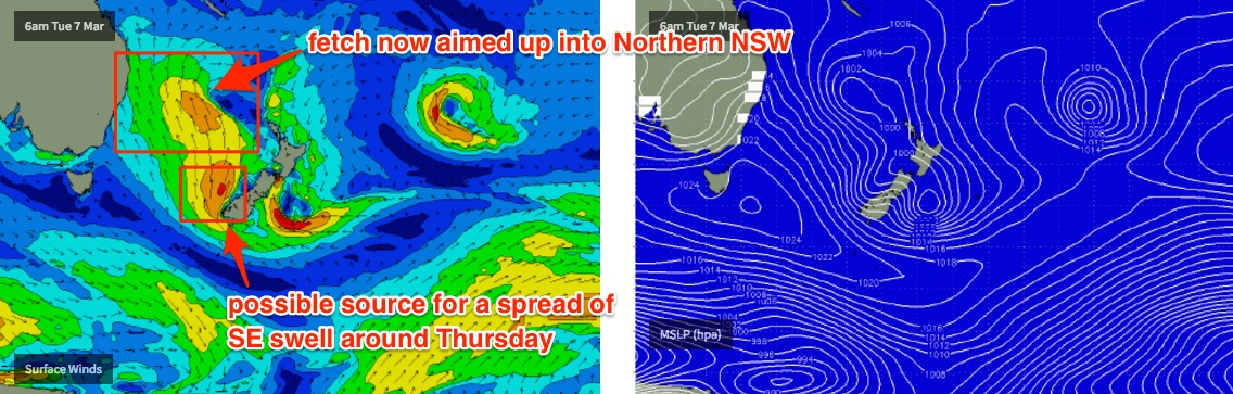
Whilst I'm still expecting at least three days of waves from this system, the primary fetch is now expected to move outside of our swell window rather quickly - aimed up into Northern NSW - and so the projected surf size has also taken a hit; our in-house surf model isn’t expecting much more than 4ft through Monday, Tuesday and early Wednesday, which is a big downgrade from what was suggested on Wednesday (and modelled right up until this morning).
Conditions are likely to be wind affected at first (Monday) but as the low draws away from the coast - from Tuesday onwards - the pressure gradient should relax, allowing lighter winds and cleaner conditions.
There’s one other region to keep an eye on next week. A small cut off low tracking through the Southern Ocean on Monday is expected to merge with the bottom of the parent system (just off the southern tip of NZ) on Monday evening and this should renew strong S/SE winds in the Far south-eastern Tasman Sea. It’s a great area for swell production but the fetch will be off-axis and therefore it’s more likely we’ll see a spread of SE groundswell through the middle to latter part of the week (around Thursday afternoon).
As of this morning I had strong expectations for a large SE swell event across the region but with two consecutive downgrades, I’m now very cautious. I’ll update over the weekend if things swing back in our fortune but for now I’m downplaying next week’s surf potential. I do however think the models are slowly underestimating surf size through the middle of the week and wouldn’t be surprised if we saw a little more size - perhaps 3-5ft to be safe? With the Sydney/Newcastle stretch likely to see the most size, and slightly smaller surf south from Sydney.
Anyway, all in all it’s a very dynamic forecast chart with lots of potential on the cards. By Monday we should have a very clear understanding as to how the middle of the week is going to pan out, so tune back in over the weekend for updates in the comments below.
Comments
I put "we’ll see a rapid translation in the nearshore zone" into google translator but it couldn't work it out either
4 ft is fine with me, its a shame about the winds though. Be a good time to be on the Mid Nth coast.
That damn south island of NZ getting in the way again too.
As I will be away for a surf weekend next, we can expect continuous downgrades on this system. Even between late last night and this morning it has got worse.
Windy tv - colour pressure map
Wow.. another curveball. After maintaining a strong, sizeable forecast (for next week) up until Friday - then downgrading signifciant within two consecutive model runs on Friday - it's swung back around to a large outlook for almost the entirety of next week. In fact Thurs and Fri could see some of the biggest waves in many months, out of the E/SE too - a great direction for many stretches of coast (not overly common either).
upgrade incoming!!! hows your job tough gig being a forecaster!!
Surely yesterday arvo came in bigger than the predicted 4ft. Must have been over 6ft amongst all that chop. There was plenty of waves getting into those southern corners
Swell direction was straight east so southern ends shouldn't have been much smaller than exposed beaches. Have heard a few reports of bigger waves that forecast yesterday though. Just a shame about the wind.
Actually s corner of manly was significantly smaller than n steye all day Saturday, no doubt about it, for reasons i dont understand. I often notice this even in straight e swells. Any explanations proffered would be good
Ben, just had a look at the charts again and can't believe the variation, as you describe. It's gone from hunting around for small rubbish next weekend to looking for places to hide!
I'm going to be clicking on weather maps all week.
It's a politically incorrect thought I know, but I kind of wish the Oxcam was around this week.
Haha, had the same thought this morning...
I'm guessing it's not coming back, unless it's just a private cam for Ben and the swellnet crew now...
Holding tight on the latest model run - might even be a slight uptick. Thursday and Friday looking seriously good.
Butterflies gathering...
The synoptic I'm looking at has that Tasman onion hanging around until Thursday.
It's a red letter bastard, eh Pete? No looking for funky fetches amongst the rings, or even rapid translations in the nearshore zone - I see you Batty Rida - this one is sitting there as bold as a fascist's jack boot.
It ain't often they're so distinct. Here's hoping for truth in forecast charts.
Stu is Frothing!!! take it easy on the rock offs......
Had a pitch black rock off this morning with no real gauge on size so I took the safer route off the side.
'Twas fantastic being out there at the dawn of what looks like an incredible week of waves. Good vibes all 'round and some smokers to boot.
Hope you got something too Mick.
i've already have a ear/nose/throat infection from all the dirty water sloshing around. i've been liberally applying the aqua ear, but to no avail.
Oh dear, to check the charts this morning after not looking since Friday.. :o
No Stu...nothing really any good on the dark side. 9.0m rogue recorded at 11.30 though.