Fun E/NE surf all week; Tasman low to generate large surf on Saturday; more solid surf next week

Sydney, Hunter and Illawarra Surf Forecast by Ben Matson (issued Monday 27th February)
Best Days: Great waves all week with a fun blend of swells from the E/NE. Possibly large (and maybe windy) weekend of waves. Next week: more large, windy surf on the cards.
Recap: Poor quality surf for much of the last three days, mainly due to onshore winds. Freshening southerlies on Saturday swung E/SE on Sunday, generating local windswells from their respective directions (2-3ft both afternoons, smaller in the mornings). Similar onshore winds held in from the E/SE today though eased a little in strength and swung more S/SE, allowing surf conditions to improve somewhat. Set waves were around the 3ft mark at open beaches.
This week (Feb 28th - Mar 3rd)
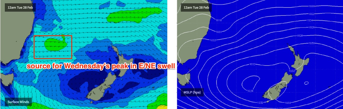
A high pressure system across the south-eastern Tasman Sea and a broad area of low pressure across the tropical waters north of New Caledonia are creating an easterly squeeze between the two.
Well, ‘squeeze’ is a slight exaggeration - it’s more of a gentle hold for now - but the point being is that we’re seeing E thru’ E/NE winds developing across a large percentage of our Tasman and South Pacific swell windows, and this will deliver a prolonged spell of energy from one of our favourite swell sources.
There are two initial regions to keep an eye on. The E/SE fetch responsible for today’s waves - just off the Southern NSW coast - is rotating anti-clockwise, and a small trough in the northern Tasman Sea will merge with it through Tuesday, slightly reaffirming the fetch in its westward push. It’ll eventually be aimed mainly in towards the South Coast (so we’ll see the biggest sets from this fetch south of Wollongong) but by no means will this result in dramatically smaller surf to the north. This will create a peak in size on Wednesday.
Whilst this is occuring, the primary fetch north of New Zealand will be slowly strengthening. The actual wind speeds won’t be spectacular, but to be honest I’m more in favour of broad, consistent fetches over large distances than super strong, tightly embedded fetches around singular low pressure systems. The resulting surf is smaller but the coastal spread is much broader, the consistency is higher and the lines are often more peaky, well suited to the beach breaks.
The second key feature to keep an eye on is a broad coastal trough, which I referred to as an ‘easterly dip’ in Friday’s notes. This trough now looks to be a little more pronounced than Friday’s models were indicating - which is not a bad thing - it’ll maintain light winds across many parts of the coast through Tuesday, Wednesday and Thursday and also assist in the development of a surface low off the Southern NSW coast on Friday. From this system we’re looking at a significant local swell event to finish the week and transition into the weekend.
So, putting this all together, and we can expect surf size across the Sydney, Hunter and Illawarra coasts to fluctuate in and around the 3ft mark Tuesday, Wednesday and Thursday out of the E/NE. Surf size could end up being a little bigger Wednesday, perhaps around 3-4ft at a handful of reliable NE swell magnets (and it'll certainly be larger across the South Coast, from the first fetch mentioned above), but conversely, we’ll see a slight easing trend through Thursday afternoon as the effects of the broad coastal trough take hold.
Local winds look pretty good each day, mainly light and variable though periods of onshores are possible at times.
On Friday, surf size should be slightly smaller from the E/NE but winds are expected to become quite gusty from the SW tending S as the low develops. At this stage it’s hard to assess how much size we’ll see by the end of the day - no major size is likely before lunch right now, but we’ll take a closer look on Wednesday. But there is the potential for a significant jump in the last few hours before dusk.
This weekend (Mar 4th - 5th)
Although there’ll be a small undercurrent of E/NE swell all weekend, the low pressure system developing off the South Coast will be the dominant influence on our weekend surf conditions.
With the actually low expected to be positioned close to Sydney on Saturday, we could see a wide range in conditions across small regions - for example, it could be strong SE south of the low (say, south of the Illawarra), S/SW thru’ SW near the low’s axis (say, in and around the Sydney region), and then W’ly north of the low (say, across the Hunter). But this is all subjective to last minute fine tuning up until the day before the event.
As for size, based on current model projections we could be looking at set waves up around the 6ft mark on Saturday, so it’ll be imperative to either find ourself a protected southern corner, or - if conditions are favourable as suggested above for a few spots - a reef handling the size.
An easing of swell and winds is expected into Sunday.
Next week (Mar 6th onwards)
The models seem to reinforce the broad scale blocking pattern by redeveloping this Tasman low through next week, possibly generating a bigger secondary swell for Southern NSW. It’s early days but at the moment we’re looking at a very active and possibly sizeable period of surf through the start of March.
Comments
Wow what a drastic improvement in quality when the when swung light SSE!
Totally, out there!!