Small windows of opportunity throughout the period

Sydney, Hunter and Illawarra Surf Forecast by Ben Matson (issued Wednesday 14th December)
Sign up to Swellnet’s newsletter and receive the Sydney/Hunter/Illawarra Forecaster Notes and latest news sent directly to your inbox. Upon signup you'll also enter the draw to win a surf trip to P-Pass for you and a mate. It doesn’t get much easier so click HERE to sign up now.
Best Days: Fri: chance for a period of light winds with a mix of NE windswell and fun S'ly groundswell. Sat: small peaky mix of swells with early light winds.
Recap: A peaky NE swell has occupied the Southern NSW coastline over the last few days, with 2-3ft surf on Tuesday easing slightly to 2ft today. Light N’ly tending moderate to fresh NNE winds on Tuesday have swung offshore NW today ahead of a shallow southerly change that appears to have just pushed through the southern Illawarra at the time this report was prepared.
This week (Dec 15th - 16th)
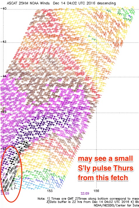 Moderate onshore winds out of the SE will spoil surface conditions at many beaches on Thursday, which is a shame as there’s a potentially fun pulse of S’ly groundswell on the way.
Initially, I’m not expecting much size - the fetch trailing today’s change won’t be very wide nor long, and wind speeds won’t be terribly strong either. So we’ll only see small surf from this source with low quality, bumpy 2ft sets at south facing beaches. The NE swell from today will have eased considerably, and will be very small by this time.
However, a powerful low passed beneath Tasmania today and the satellite images showed a marginally better aligned region at the bottom of the system than what was modelled (see right). Most of the winds were aimed away from the mainland but a tight pocket of embedded 50kts SW winds around the low’s south-western flank have provided a glimmer of opportunity.
This should kick up an inconsistent southerly groundswell that will glance the Southern NSW coast throughout the afternoon on Thursday. I’m not expecting much size - maybe some inconsistent 2-3ft sets at exposed south swell magnets after lunch and a few bigger bombs late afternoon across the Hunter - but the models aren’t picking it up at all, and it’s a shame that the local onshores will create bumpy conditions as it would have otherwise been a fun little groundswell to play with.
Winds will be lighter form the Illawarra to the Far South Coast so conditions should be a little more manageable here.
On Friday a new trough will develop across the coastal margin, swinging the winds around to the east as they spread south, ahead of a fresh northerly breeze developing from the north (i.e. Hunter region) throughout the afternoon. Between the two we should see a period of light variable winds; this is likely to be across the Sydney region for much of the day though periods onshore winds can’t be ruled out.
As for surf, a second pulse of groundswell originating from a secondary front (wrapping around the primary low expected to produce Thursday’s pulse) will push up the coast. Although this fetch was a little too zonal in structure, its considerable strength and width should allow enough energy to spread up the coast, providing 2-3ft sets at south facing beaches. There’ll also be a minor peaky mix of short range east swell in the water too, from the local fetch under the trough.
So overall, nothing special - and there’s certainly a chance local winds could throw a spanner into the works - but exposed beaches should have some little peaks to finish the working week.
This weekend (Dec 17th - 18th)
It still looks a little complex for the weekend.
Saturday will see a peaky mix of swells from a couple of sources - a minor NE swell from a fetch off the Mid North Coast overnight Friday (odd 2ft set), and some leftover S’ly swell from Friday’s pulse (occ 2ft+ south facing beaches).
Conditions should be generally clean with light offshores and sea breezes ahead of a late gusty S’ly change arriving across the South Coast that should reach Sydney in the early evening.
This southerly change will whip up a punchy, albeit short lived swell for Sunday. The models are a little overly-enthusiastic about wave heights right now - I think their 5ft estimate for south facing beaches is a little hot, and it’ll probably come in around the 3-4ft mark. Though with fresh southerly winds on hand quality will be hard to find.
Expect much smaller surf at beaches not open to the south. Winds should ease into the afternoon too, so there may be some late lumpy options. But overall I’d recommend a surf on Saturday for the cleaner conditions, despite the smaller size.
Next week (Dec 19th onwards)
There’s still nothing definitive to pin down for the long term, but the tropical system around Fiji mentioned in previous notes is looking better and better with each model run. Essentially, it’s a slow moving system that should generate some form of long range E/NE swell for the middle to latter part of next week, though it’s way too early to gauge how much size we could see.
Otherwise, northerly winds re expected for the first half of next week ahead of a mid-week S’ly change.
See you Friday!
Comments
hi ben, are we still on for the south swell for tomorrow on the south coast???