Easing S'ly swell this weekend, small sources for next week

Sydney, Hunter and Illawarra Surf Forecast by Ben Matson (issued Friday 14th October)
Best Days: Sat: small leftover south swell with early NW winds. Mon: small peaky NE swell across NE facing beaches with winds tending W'ly during the day. Wed PM: small S'ly swell.
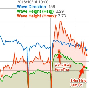 Recap: Solid southerly swells built across Southern NSW on Thursday morning, punching a little higher than expected with solid 4-6ft sets on offer at south facing beaches. Size eased a little overnight (disproportionate to the large drop in size recorded at MHL’s Sydney buoy, which eased from 4.2m Hsig at 8am Thursday to 2.4m Hsig at 8am Friday, see right); south facing beaches were still 4-5ft this morning, and much cleaner under a light W’ly breeze. Locations not open to the south have seen much smaller surf but conversely, we’ve seen large waves across the Hunter.
This week (Oct 13th - Oct 14th)
Not much more than an easing trend expected this weekend.
Today’s south swell will continue to fall into Saturday and it’ll trend down through the afternoon and further into Sunday. South facing beaches should see early 2-3ft sets around dawn on Saturday (a little bigger in the Hunter, but smaller at beaches not open to the south) and you’ll have to make the most of the early size size as freshening NW winds are expected to swing N’ly mid-late morning then fresh N/NE into the afternoon.
Sunday’s not likely to see much size from the NE windswell, perhaps 1-2ft at well exposed north facing beaches but it will be pretty weak in structure. Winds may temporarily veer NW in the morning but again the afternoon is looking at freshening N/NE breezes which will wipe out size prospects at most beaches.
There’ll be hardly any south swell leftover by this time either, just a foot or two at the swell magnets early and very little throughout the afternoon. A small rise in local windswell is possible late afternoon, but Monday will probaly see the most size from this redeveloping local fetch.
So, long story short: make the most of Saturday morning.
Next week (Oct 17th onwards)
Sunday night’s freshening N/NE breeze looks a little more robust on the synoptics and this should kick up a bigger local swell for Monday morning, but only at NE facing beaches. I’m not 100% confident in this fetch as it’s quite north in direction and the bulk winds will be quite some distance offshore (blowing almost parallel to the coast) but we do often see some fun waves form these sources when they are stationary (as this one is expected to be).
An approaching shallow S/SW change - due into the South Coast in the afternoon and Sydney after dinnertime - is not expected to push the northerly fetch offshore until Monday evening. So this should maintain some kind of NE windswell about Southern NSW for much of the day. Winds will veer W’ly ahead of the change so there’s a chance for a fun session of waves at exposed NE facing beaches, set waves may push the 2ft to maybe 2-3ft range though I’d only give it a 60% confidence right now: we could easily see this local swell source shunted out of our window with future model updates. I’ll update over the weekend if I see anything drastic.
Otherwise there’s nothing of interest for the rest of the working week. Smaller surf and mainly light winds will prevail on Tuesday ahead of a small pulse of S’ly swell on Wednesday afternoon, originating from a front pushing through the lower Tasman Sea in the early hours of Wednesday morning. We might see some 2-3ft sets at south facing beaches but otherwise it doesn't look worth getting excited about.
Freshening N/NE winds across Southern NSW through Thursday afternoon and Friday should kick up a recent short range NE windswell for Friday though quality is hard to estimate at this early stage.
And the only other area to keep an eye on next week is a small stationary trough south of Fiji early next week. Wind speeds are not expected to become especially strong but it should be sufficient enough to generate a small E/NE swell for the coast, probably around Thursday or Friday of next week (though it may be hard to distinguish beneath the local NE windswell).
Have a great weekend, see you Monday!
Comments
Nice morning lines across Bondi, and some decent sized waves in Newy too.
Thanks Ben sure been a grind lately.
Not a lot of size this morning but the odd 2ft to almost 2-3ft set at Manly. Long wait for waves though.
Jeez this high tide is really swallowing up the short period NE swell. There's a couple of little peaks at Maroubra but it's pretty uninviting (though, everyone missed the nice little bowl in the second surfcam still image, below).
Hopefully it'll get better as the tide drops though the swell will be easing by this time.. double whammy!
couple peaky ones at Narrabeen Ben although every man and his dog was out
Still a couple out there! Hope it hangs through the tide.
Gawd, it's only just hanging in there...
Nice set just came through, this is shoulder, almost head high. So still within forecast spec which is nice. Super clean now too.