Early peak in S'ly swell on Saturday; smaller residual swell otherwise

Sydney, Hunter and Illawarra Surf Forecast by Ben Matson (issued Friday 27th May)
Best Days: Saturday: solid but inconsistent, and rapidly easing S'ly swell, clean with offshore winds. Sunday: small clean S'ly swell.
Recap: Wednesday’s very large S’ly swell eased rapidly into Thursday and further into Friday morning, under clean NW tending W’ly winds. A new S’ly swell is building across the region, with 3-4ft sets now showing at south facing beaches.
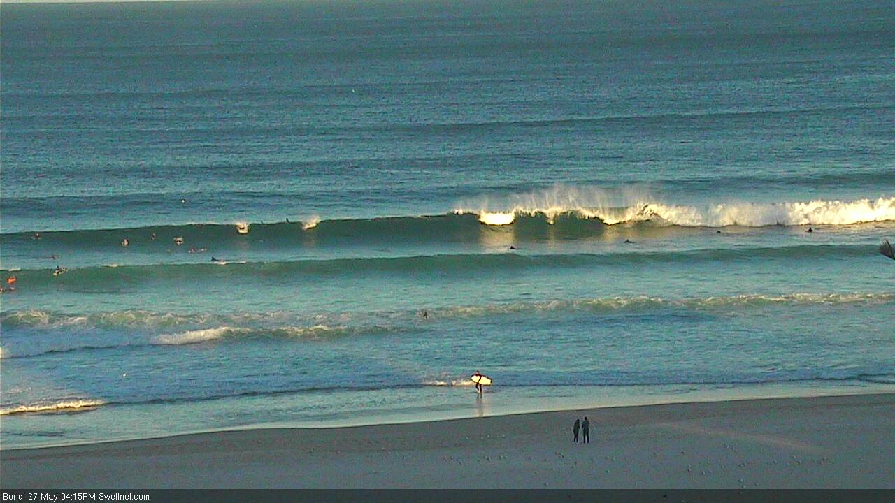
Afternoon sets at Bondi
This weekend (Saturday 28th - Sunday 29th):
 The fetch responsible for today’s building S’ly swell is quite incredible (see satellite imagery to the right, taken this morning).
It’s quite tricky to estimate the size potential from this system, as satellite derived winds are actually better aligned than what the models predicted (this increases the swell potential). But overall the broader system is expected to track NE, away from our coast (which reduces the swell potential).
Also, this system is located almost entirely north of Bass Strait latitudes - for the best southerly swells, we prefer the associated fetch to extend well south of Tasmania. The general idea here is that swells requires a certain distance to become fully developed - if you’re too close to the swell source, you’re at risk of not seeing the maximum potential from the fetch strength. Compounding this is that the fetch is aimed away from the coast, so any “swell spread” we see back into the coast is also reduced below the axis of refraction (which will probably be around Wollongong or thereabouts).
In short, your size potential will proabably be greater as you head north along the NSW coast (though the Hunter curve compounds this issue for the North Coast; that's another story), and smaller as you head south.
And as we saw on Wednesday, complex systems like this usually throw lots of curveballs our way too.
Also making Saturday’s forecast tricky is a developing E’ly fetch along the bottom of the Tasman low, which will veer SE in direction as the low tracks NE. This fetch will be well positioned within our swell window at some point (good for swell potential) but will last only a brief time (bad for swell potential).
See all of the variables at play?
In assessing the current surf conditions, we've already seen a decent increase in new energy start to show later this afternoon but right now there's no major size showing in Sydney, or across our Illawarra surfcams. As such I'm downplaying the size potential from this fetch as I think it hasn't lasted long enough in our swell window to maximise the strengths seen in the surface wind field.
Right now, the models have strong southerly swell all weekend, but I think they're overcooking the size from Saturday afternoon onwards. It’s quite likely that we’ll see a strong peak in size overnight tonight, but then a steady easing trend all day Saturday, with small surf prevailing through Sunday.
South facing beaches will see the biggest waves; I’m estimating inconsistent early sets around 4-5ft at reliable south swell magnets at dawn on Saturday (possibly a bigger near 5-6ft+ in the Hunter, but smaller south of Sydney). Overnight - if it were possibly to see through the darkness - south swell magnets could very well push north of 6-8ft, but I just don’t think the peak from this swell is going to last much longer than a few hours, and most of it will be occur under the cover of darkness.
Saturday morning’s early size will trend downwards steadily all day; by lunchtime we’ll probably be around 3ft+ at Sydney’s south facing beaches, and then mid-late afternoon down to 2ft+. All the time, expect smaller surf at beaches with less southerly exposure. Conditions should be clean with moderate to fresh W’ly winds, tending SW in the south during the day and becoming quite gusty late afternoon.
As for Sunday, a redeveloping S/SW flow off the South Coast late Saturday should renew short range S’ly swell across south facing beaches (north of Wollongong) throughout Sunday, pulsing in the 2ft to very occasionally 2-3ft range all day. Bigger waves are also likely in the Northern Hunter region too, but once again - expect smaller surf at beaches with less southerly exposure (and also, locations south of Wollongong).
Local winds are looking better on Sunday too with light to moderate W/SW winds all day.
Next week (Monday 30th onward):
The weekend’s local S/SW fetch off the South Coast should maintain small S’ly swell energy for south facing beaches on Monday but it’s expected to ease during the day.
Otherwise, there are no major sources of swell for next week. A small S’ly fetch in the eastern Tasman Sea (associated with the current Tasman lows later developments across NZ early next week) may deliver some sideband energy for mid-late next week but such a scenario would mainly favour the northern part of the state (owing the to the way the swell will spread back into the East Coast). Don’t pin your hopes on anything for now.
A polar low tracking off the ice shelf on Sunday - that may become absorbed into the broader NZ system early next week - may also generate some side band energy mid-late next week but no great size is likely from this just yet.
A trough pattern is then expected to develop across the East Coast, but with no great swell potential. Therefore, much of next week will see small residual swells at exposed beaches, and mainly light variable winds.
Towards the end of the week, the coastal trough is expected to consolidate, forming a fresh N/NE fetch and a surface low off the South Coast that could generate a some punchy NE swell throughout Friday and into Saturday. But these systems are quite volatile in where and when they develop (using long range model guidance) and its close proximity to the coast means confidence is low - for example, if you shift the modelled position of the trough 150km west, we won’t see much, if any swell - but there are other synoptic scenarios that could work in our benefit.
In any case it’s looking like more of a typical autumn pattern developing later next week (ironically, in the first few days of winter) and there’s a good chance that we’ll see some strong swell potential over the forthcoming days (Saturday onwards). But it’s way to early to estimate potential size and conditions.
Have a great weekend, see you Monday.
Comments
Jeez, what a bloody hard forecast. Pressed the green button after waiting all afternoon for the south swell to jump above model forecasts, but it hasn't done so yet. Could very well happen overnight but that's the risk that has to be taken.
started to show at dusk some signs of southerly energy, even the banks at southy looked good! although very inconsistant
I was really happy about the undersized predictions of the last swell
that was good. This swell well just wait and see.
On a side note windguru had it pretty spot on.
Windguru had what spot on?
Ahhh, the wonderful complexities of south swells in Sydney, and the apparent poor correlation between buoy data and surf size.
So, late Friday seemed to reach somewhere around 3-4ft at Bondi (I had the surfcam streaming almost continually from about 3pm onwards). I checked our surfcams to the south and nowhere was showing any indication of a significant size increase before sunset. But RapidScat (satellite data) picked up an incredible 50-60kt fetch that should have been the source of a major pulse sometime late in the day or overnight.
As per MHL chart, the Sydney buoy increased to 2m+ out of the south late afternoon with peak swell periods around 10 seconds.
And as suggested in the notes above, we certainly saw the swell kick substantially overnight - Significant wave heights increased another 30% to 3m+, and peak swell periods jumped from 10 seconds to 15 seconds.
Unfortunately (and also as per my notes above), wave heights and swell periods have dropped since about 2-3am. But as of the latest data (5am) right now they're still well north of the values seen late yesterday.
So, surf height should still be a little bigger than late Friday, right?
Nope, Bondi is maybe four foot on the bigger bombs, and more times often than not they're single wave sets.
And the general look of the ocean suggests an easing swell, so I think the dropping trend mentioned in the notes above (for today) will probably kick in earlier than I expected. Wouldn't be surprised if it's down to 2ft+ at south facing beaches by early afternoon.
Thoughts on swell heights for tomorrow down near cronulla?
Lets wait and see how today pans out.
Ben, do ya think well see some 4 footers at dawn tomorrow morning along the NB?
Bombie was pumping this arvo with some 5ft sets easy!
Great waves along the NB this morning. Mid day tide slowed things up, LR bombie still showing some size
I checked everywhere from narrabeen to Palmy this morning and no where was great. Mostly closeouts. Warriewood had a few fat burgers and South Whaley had some ok waves but nothing to write home about
Sounds like a typical south swell on the Northern Beaches!
Yep, it was. So frustrating
Eel their were a few runners just had to be patient...
where? I spent ages looking and it was close out city.
I'll give you a hint, south of narra
White rock or longy? I surfed at longy today (sunday) was fun.
Baaaaaaaa East Coast.. was there for 3 weeks. Flat nearly all the time....day I left, swell finally....you suck
Baaaaaaaa wrong timing Tits;)
It was pretty solid early Sat, surprised that you say Bondi only showing 4' as it was bigger than that at nearby beaches that don't face south.
Swell stayed in all day too, with still 3-4' and multiple wave sets at the end of the day, and today still 3'+. Maybe better after I spend a bit of time out there. Your site calls it at 3-4 this morning.
Just silky yesterday all day. Straight as at the local but the occasional one gave you some shoulder to work with. I had fun anyway. :-)
Huge lumps on the horizon today also, swell on it's way to Fiji or thereabouts
Plenty of swell on the south coast yesterday. Had cause to go south that didn't involve surfing but still slipped in three sly sessions around the Bendalong/Ulladulla stretch where everywhere exposed was at least 6' or even further north. Absolute glass through the morning too.
Hey stunet, stoked that you had a good weekend and got some waves. I'm not trying to start some war of words here, and im trying to be positive, however I dot really see the need to go advertising the locations that you scored. Sure, there are a lot of waves between Bendalong and Ulladulla, and most informed surfers tend to know the general conditions these waves work in, but shouting out to the net where you have been and how good conditions were is pretty bad form, especially for someone like yourself who is listened to by so many surfers. Help keep the dream of the adventure and discovery alive for your readers by keeping some key descriptors to yourself. Have a great week.
Thanks for the positivity, though I reckon you're being a bit over-sensitive. The discussion on the forecast threads is about which regions came in on the money, which under, over etc. It's always been this way. Saying what the size was 'somewhere' within a broad region 24 hours after the fact is hardly something to get up in arms about. Didn't mention specific locations nor even wave quality.
Naming a stretch of coast is neither here-nor-there IMO, and as you said not specific spots, photos etc.
But I must say that in my nearly 5 years of residing in the South Coast region I've observed an increasing prevalence of what appears to be Sydney weekend warrior surfers out and about. I think there is an increasing willingness to do bigger k's to get to more uncrowded areas but this inevitably causes angst in some of the more tightly held spots.
Or maybe everywhere is just more crowded.. the amount of people who read these comments who don't already have a fair idea as to what your stretch of coast was doing over the weekend would be sfa. Hope ya snagged a few!
A trip south for non-surfing reasons and you managed to fit in 3 sly sessions in one day!!!!!!!!!!!!!!!!
You lead a dissolute life my friend. :-)
Swell still hanging in today and easy 3-4ft.
Fun in the sun..