LWT encroaching on NSW swell window. Multiple S'ly pusles

Sydney, Hunter and Illawarra Surf Forecast by Guy Dixon (issued Monday 9th May)
Best Days: Tuesday and each day from Thursday looking good.
Recap:
Open beaches were the places of interest over the weekend with an easterly trade-swell ebbing and pulsing. Saturday saw fun options in the 2-3ft range, with conditions remaining clean until early afternoon (those light land breezes drawing smoke over the coast for parts of Sydney).
Sunday saw a lull with that easterly swell failing to provide much more than 2ft with the tide also masking some of that energy. Wave quality was less impressive with a light northerly breezes just adding a small amount of bump to the mix.
Today, the swell has pulsed slightly, with the better sets back up in the 2-3ft range, although inconsistent at times.
This week (Tuesday 10th - Friday 13th):
The coming week is looking dynamic to say the least.
Before we get into the details, easterly trade-swell that has been breaking over the weekend will slowly fade, easing from the 2ft to occasionally 3ft range on Tuesday, becoming small on and overshadowed by building southerly energy on Wednesday.
Conditions are likely to remain clean for the majority of Tuesday and Wednesday with northwesterly breezes tending more west/northwesterly.
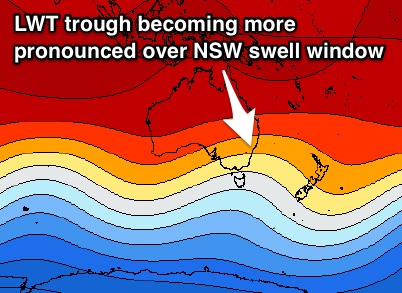 A series of fronts are due to move through our southern swell window from Tuesday onwards, generating multiple pulses in the days following.
The initial front moving over Tasmania on Tuesday is likely to steer two favourable fetches through the NSW swell window - the first a westerly fetch exiting Bass Strait, followed by a more distant south/southwesterly fetch positioned to the southeast of Tasmania.
As a result, south facing beaches should pick up two distinct pulses, the first building to around 3ft+ on dark on Wednesday, with the first peak likely to be move in overnight. Thursday morning should see continued energy due to westerly fetches persisting over eastern Bass Strait, in addition to the longer range pulse which looks to build to the 3-5ft range (larger across the Hunter).
The next front looks to follow in quick succession, following a similar track later on Wednesday evening.
This time, the sea-state will be well activated allowing for more efficient swell generation. We should see a pulse fill in during the overnight hours steered by the mid-range westerly fetch, followed by better ground swell on Friday morning to around 4-5ft at exposed south facing beaches (bigger on the Hunter).
Conditions look to remain generally clean each day under a westerly airflow, however Friday should see breezes ease with the possibility of a weak seabreeze in the afternoon.
This weekend (Saturday 14th - Sunday 15th):
The third front looks to move in a more zonal motion overnight from Thursday into Friday, providing a strong pulse into Saturday. The longer range ground swell looks to catch up with the mid-range as it migrates northward, providing a mix of southerly energy in the 4-5ft range on Saturday morning (once again the Hunter likely top pick up more size).
Finally, a weaker and less favourable frontal progression looks to move in a similar zonal motion during the early hours of Sunday morning, providing a small pulse late in the day.
In comparison, this particular swell front looks fairly insignificant, although should slow an otherwise easing trend, keeping sets in the 3-4ft range late in the day.
Saturday morning is looking good under a light northwesterly airflow, with seabreezes likely to develop throughout the afternoon. Similarly, Sunday should remain clean for the first half of the day under a light west/northwesterly airflow, although a seabreeze looks to come up once again in the afternoon.
Next week (Monday 16th onward):
The long term outlook suggests more of the same. The fronts look to persist, leading to a spell of regular southerly groundswells.
Comments
Halle"bloody"lujah!
The lows still seem to be deflecting in a more SE direction when they pass Tas. The Hunter like magnets will do well but can see the south coast underperforming (in a relative sense) due to shadowing.
I agree, relatively/comparitively being the key word.
Finally winter is here!