Fresh swell over the weekend, cleaner conditions next week

Sydney, Hunter and Illawarra Surf Forecast by Guy Dixon (issued Friday 22nd April)
Best Days: Lighter winds and cleaner conditions winds next week.
Recap:
The week has come to an end with small surf filling in out of the east with sets in the 2ft range at most open beaches. Although modest, options have been workable on the right craft under light offshore breezes each morning before giving way to a seabreeze.
This weekend (Saturday 23rd - Sunday 24th):
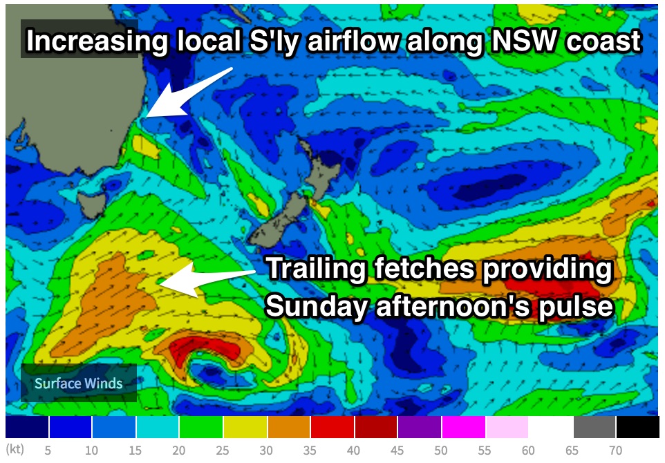
Things will begin to kick off later today as we see breezes swing southerly and increase throughout the afternoon and overnight. This increasing southerly flow is all part of a larger scale system, but the initial effects should come in the form of a short range southerly windswell which is due to build Saturday afternoon to the 3-4ft+ range at south facing beaches, steered by south/southeasterly winds of 25-35kts pushing into the coast into Saturday morning.
The cleaner options are likely to be limited to protected southern corners where size will be negligible as a gusty southerly airflow tends south/southeasterly. However, selected locations south of Sydney may see an early south/southwesterly breeze.
 Saturday's swell will ease from the S/SE Sunday from the 3ft+ range across south facing breaks (larger Hunter) ahead of a stronger building groundswell energy, generated by a pair of systems over the Southern Ocean earlier in the week.
As detailed in Wednesday’s notes, an initial frontal progression moved traversed across the Bight, but ultimately dipped southeast as it moved south of Tasmania, hindering swell potential, but activating the sea-state for a more favourable front to follow.
The second frontal progression is currently moving to the south of Tasmania and is associated with this afternoon’s change. Long period energy generated earlier in it’s life cycle is due to fill in at around the same time as the energy off the previous less favourable system (stronger winds make for longer period swell which catches up to comparitively shorter period energy).
As this system rounds the corner of Tasmania into our more immediate swell window, broad southwesterly trailing fetches should provide a small lift in energy due into Sunday afternoon, although not quite as promising as what we thought on Wednesday.
In comparison to recent model runs, the winds look marginally weaker and more distant, so the size has been downgraded slightly as a result. Nevertheless, these mix of swells should see south facing beaches build to around 3ft, with the odd bigger set breaking later in the day.
One final swell will be in the water from the E/NE Sunday and Monday to 2ft, generated by a weak but stationary fetch of E'ly trades just above New Zealand.
Winds look like an issue though, prevailing from the southeast most of the day. Again, spots south of Sydney have the chance of seeing an early southwesterly breeze.
Next week (Monday 25th onward):
As a ridge builds in the wake of today’s change, breezes will tend more southeasterly, particularly along the coast of northern NSW and southeast QLD. Monday should pick up an element of easterly energy filtering down from these fetches to around 2ft, in conjunction with left over southerly energy easing from the 2-3ft range.
The early session is looking fun with light/variable-southwesterly breezes on the forecast, preceding a very light seabreeze.
While these swells are breaking on our door step, yet another southwesterly fetch will be moving south of Tasmania and traversing the southern Tasman, with good intensity, but ordinary alignment.
The early stages of this system are most favourable for the NSW coast, with 35-45kt southwesterly core fetches moving well to the south of Tassie. The system looks to intensify (core winds up to 60kts) and move in a captured motion towards Stewart Island (which has the potential to get pumped), but unfortunately this is too late in our swell window for any decent gain.
Energy from earlier in the swell window is our best hope for swell, plus a touch of sideband energy from it’s later stages perhaps. The effects of this system are due to fill in on Tuesday, with sets in the 2-3ft range.
Light/variable-offshore breeze look to persist for most of the day, before a light seabreeze comes in.
A blocking set up looks to become established with the the aforementioned ridge showing very few signs of budging until the second half of next week. As a result, frontal activity is likely to be deflected south and lack any decent alignment for the NSW coast.
Instead, open beaches will be the best bet for a wave as easterly energy filters down from a trade fetch better suited to southeast QLD mid-week.