More size on the weekend, winds causing issues

Sydney, Hunter and Illawarra Surf Forecast by Guy Dixon (issued Wednesday 20th April)
Best Days: No great days, undersized or wind affected.
Recap:
We have seen clean conditions persist well into the late morning over the past couple of days, with seabreezes only bringing minimal impacts once they became established.
Southerly energy faded throughout Tuesday, although south facing beaches continued to pick up sets in the 3ft range. Easterly swell has been providing fun options across the open beaches, with sets in the 2-3ft range on Tuesday, more so in the 2ft range today.
This week (Thursday 21st - Friday 22nd):
The remainder of the week is looking fairly benign, with small background energy filling in from our southern swell windows, generated by poorly aligned and weak frontal activity.
Exposed south facing beaches should continue to see small ebbs and pulses between 1-2ft until the weekend.
Friday is still on track to see a slight pulse of easterly energy off a modest easterly fetch which has been residing off the North Island of New Zealand, although fairly underwhelming with occasional sets in the 2ft range across open beaches.
The run of light winds also looks to continue, at least on Thursday with light northwesterly breezes leading to clean conditions during the morning, with only gentle northeasterly seabreezes coming in from the late morning.
Friday morning is likely to see a southwesterly airflow along the Illawarra and Sydney coasts, more so west/southwesterly along the Hunter, tending more southerly and increasing throughout the day.
This weekend (Saturday 23rd - Sunday 24th):
The weekend is looking much more dynamic, with a number of short range and long range systems kicking off in the days leading up.
A southerly change looks to move up the coast on Friday, becoming gusty during the afternoon and throughout the evening. A local southerly windswell is due to build throughout Saturday as a result, larger than anticipated in Monday’s notes.
Exposed south facing beaches should build to a low quality 3-4ft+ under a gust south/southeasterly breeze, persisting for most of the day.
Cleaner options will be on offer across protected southern corners of the open beaches, but without much size as small residual easterly energy fills in.
Longer range energy is due to fill in on Sunday, generated by a pair of frontal progressions moving over the Southern Ocean earlier in the week.
The initial, less favourable system is currently moving south of WA with a modest sized westerly fetch with core winds of 30-40kts. The storm track of this system is poor however with models suggesting that it’ll drift south and weaken.
A second follow up system looks to develop south of SA with stronger more elongated fetches of 40-45kts. Unfortunately as this system moves south of Tasmania, it looks to weaken and become disjointed.
These two swells look to fill in across south facing beaches at around the same time, providing options in the 3ft+ range for the majority of the day.
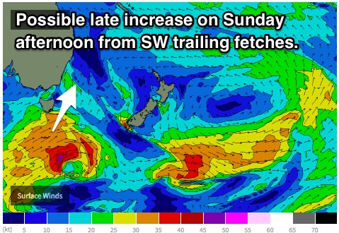 Trailing fetches rounding the southeastern flank of Tasmania in the wake of the second system have the potential to provide an increase in size throughout the afternoon however, so more consistent sets are likely later in the day.
Meanwhile, the effects of an easterly trade fetch north of New Zealand look to fill in, with open beaches picking up options in the 2ft range on Sunday.
Despite winds easing, wave quality is likely to be lacking under a southeasterly airflow (more offshore across the far South Coast). Not many decent options will be on offer.
Next week (Monday 25th onward):
Southwesterly fetches off the backside of the weekend’s system should maintain energy throughout Monday, although really only slowing an otherwise easing trend. South facing beaches should continue a slow decline from the 2-3ft range, easing from 2ft on Tuesday.
The early session should see clean conditions under a light southwesterly airflow, particularly south of Sydney where breezes could seeing light westerly.
Further ahead, easterly trade-swell spreading down from a strong stationary ridge which is well aligned to the QLD coast should fill in across open beaches, with options in the 2ft range.
Comments
Coupla fun small waves at Bondi this AM.