Multiple swells, light offshore breezes each morning

Sydney, Hunter and Illawarra Surf Forecast by Guy Dixon (issued Monday 21st March)
Best Days: Each morning, particularly Thursday, Friday and Saturday.
Recap:
A southerly swell pulsed hard Saturday with sets in the 3-5ft range by mid-morning, before kicking even harder late in the day and into Sunday morning with bombs in the 8ft range at exposed magnets and offshore reefs. In terms of quality, Saturday morning started off strong under a westerly breeze, tending south/southeasterly. Sunday slowly swung from the southwest to the southeast by the afternoon.
Today, the swell has dialled back a touch, with sets now in the 4-5ft range. Options were a little raw early, but we have seen good waves at most beaches after a few hours of offshores.
This week (Tuesday 22nd - Friday 25th):
Southerly energy will continue to fade throughout Tuesday, slowed only by a weak fetch extending from the southern tip of New Zealand’s South Island to the NSW coast.
Options should ease from around 4ft throughout the day, further on Wednesday from the 3ft range.
Meanwhile, we can expect the surf to increase across open beaches as the effects of an intensifying trade flow fill in. A strong ridge to the east of New Zealand has been interacting with a trough to the north steering a broad, stationary and well aligned easterly fetch towards the QLD and NSW coasts.
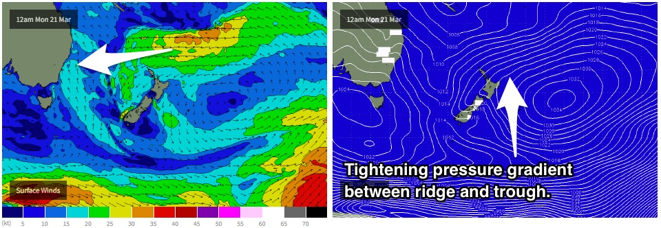
As a result, the surf will gradually build in the days to come, with swell periods steadily increasing each day to a peak late in the week.
Tuesday should see options in the 2ft range, increasing throughout Wednesday to the 3ft.
This swell is then due to peak late on Thursday as a result of a slight intensification and retrograding motion of the fetch, with sets in the 3-4ft range. Exposed beaches and swell magnets have the potential to see the odd 5ft bomb, fading from a similar size range from early Friday morning.
Meanwhile, poorly aligned fronts throughout the week have been stirring up the Southern Ocean, priming the sea state for a series of fronts which look to produce groundswell for the magnets late in the week.
The first pulse is due late on Friday, generated by a tight southwesterly fetch southwest of Tasmania. South facing beaches are due to see inconsistent sets building to the 2ft to occasionally 3ft.
We are looking at a pretty good run in terms of breezes in the next few days. Southwesterly breezes are on the cards for Tuesday morning, before the tail end of this southerly run has an impact on the quality late run the day.
For the remainder of the week however, we can expect light, offshore breezes each morning, with a light seabreeze coming in during the late morning (earlier by Friday).
This weekend (Saturday 26th - Sunday 27th):
We are likely to be in between swells on Saturday, with Sunday due to see a second, better pulse generated by a stronger system with more intense and broader core fetches working further south in the Southern Ocean. The resultant swell should peak on Sunday morning with inconsistent sets in the 3-4ft range.
The final pulse is expected to follow soon after, generated by a less favourable system working the already very active sea-state. We should see Sunday afternoon kick with sets in the 3-5ft range at exposed south magnets.
The run of workable winds will continue into the weekend, with each morning looking at light northwesterly breezes. Conditions should be clean until mid-morning preceding a seabreeze.a
Next week (Monday 28th onward):
Early next week should see an easing trend across all coasts as each swell window quietens down.
More detail on Wednesday.
Comments
epic day of waves!!!
Thanks Guy. Will the trade swell that you're forecasting tend to get smaller as you move down the coast?
Just nutting out the details of today's forecast. The E'ly fetch has been tending more NE, beter aligned for southern NSW throughout yesterday (see attached). Later stages of the swell should favour your neck of the woods.
This is what, I was referring to, in your Monday notes for SE QLD?
Bit bigger than the forecast 2-3 foot this morning fellas. Freshie was huge, even Queenscliff bombie broke a few times. Had to do an emergency dust off of the step up. Close out city by myself for an hour. Lots of water moving around.
Yes, regretfully this swell managed to slip through our fingers. Interesting to note that models also struggled showing just 0.4m @ 17 or something there abouts.
i loaded up the sub 6 foot boards this morning... should've known it was biggish when there was only a couple of fellas at my south facing local and a big crowd at the east facing. lucky it was high tide otherwise the beatings would've outweighed the couple of gems i fell into.
Just got in after a great 3 hour session. Interesting to note MHL buoy showing 2.9m at 18 sec.
The spectral shows a lot of this longer period energy out of SE but also some similar long period out of the NE.
The double-ups were happening as the longer period sets overtook the mid period in-betweeners.
This morning's S'ly groundswell was produce by a vigorous polar low south-west of Tassie. Produced good 8-10ft waves at Shippies with 12ft bombs, and has come in strong here.
MHL Spectra stuffed, OK for energy from the south, but its alignment is off and wrong. Doesn't represent anything from NE to E/SE well either.
Yes I have noticed MHL wave rose / spectra is a bit useless. Totally under calls any energy from E through to N. Can be useful in picking up pulses from the South. Any idea if they are going to fix it?
Unfortunately not that I know of, so annoying and the data is 3 hours old anyway, useless!!
Spectra is broken you need to use the graph as it still works!

Yeah of course, but that data is still from 11am, and it's 2pm now. Not good for identifying incoming swells in real-time.
Not quite - the plot doesn't have a mechanism to account for day light saving.
I emailed MHL during cyclone Winston and told them the spectra plot was off, they then put up the note at the top saying not to read it... my take is that it gets the swell size and period right just direction completely wrong. Wish to he'll I checked it this morning on my 4am trip to the pisser..
I got a couple of pulses read in conjunction with adjoining buoys it will do for a punter. Update every hour. 3-5 foot the other week swell net had 1-2ft was great crowd was zero!
That's the way Pills;)
Good work....