A mix of E/NE groundswell and solid S'ly energy next week

Sydney, Hunter and Illawarra Surf Forecast by Guy Dixon (issued Friday 12th February)
Best Days: Early each day of the weekend for a small wave. Protected southern ends on Tuesday and Wednesday. Thursday
Recap:
Most beaches picked up fun 2-3ft options on Thursday, with clean conditions in the morning under light winds. The afternoon seabreeze remained fairly light only adding a small amount of bump, but conditions remained generally workable along the coast. Today, the energy has faded a touch, however hints of southerly energy are also in the mix, providing options in the 2ft range.
This weekend (Saturday 13th - Sunday 14th):
Background easterly energy should continue to fill in across open beaches throughout the weekend generated as sideband energy off a Tasman ridge which has better alignment to the northern NSW and QLD coasts.
Saturday and Sunday should hold in the 1-2ft range, with a small amount of northeasterly windswell in the mix on Sunday generated by local northeasterly breezes which are due to increase ahead of a change.
The early session is looking clean on Saturday under a light northwesterly breeze, although soon swinging northeasterly and increasing. Sunday morning should also see a period of northwesterly breezes in the early morning, becoming seabreezey before the aforementioned southerly change moves through in the afternoon/evening.
Next week (Monday 15th onward):
More size is on the cards for the start of next week, although downgraded since Wednesday’s forecast.
Initially, easterly energy generated by a slight intensification and more favourable alignment of a ridge over the northern Tasman should provide fresh swell for Monday, although the sets only look to be in the 2ft range.
South facing beaches can expect a small, short range southerly windswell generated by the change the previous night, fading from the 2ft range and lacking power.
There is a small amount of model disagreement regarding the wind outlook for this day. Some models suggest an easing southeasterly breezes while others are more in favour of a variable airflow, increasing from the northeast during the afternoon.
During the early stages of Sunday, Tropical Cyclone Winston looks to drift south and interact with this ridge, ultimately steering healthy east/northeasterly fetches song the southern quadrants.
Longer period pulses with more substantial size should fill in on Tuesday, with inconsistent sets building to the 3-4ft range in the afternoon, holding throughout Wednesday as secondary pulses fill in.
Models have come more into line regarding the timing and position of a deep cut-off low, well at least for this model run.
A deep low pressure system looks to develop within a strong frontal progression over the Southern Ocean on Monday, eventually becoming completely severed by the strong upper level westerly airflow. This process of being displaced and the resultant system is often referred to as a 'closed low' or 'cut-off low' which then have little influence by the westerly airflow along higher latitudes.
Systems like this can often linger or even retrograde (move in the opposite direction to the usual migration of weather systems), acting on a particular part of the ocean of a prolonged amount of time.
In this instance, this system is due to move to the south of Tasmania late on Monday evening and into the NSW swell window from Tuesday morning, with multiple intensifications.
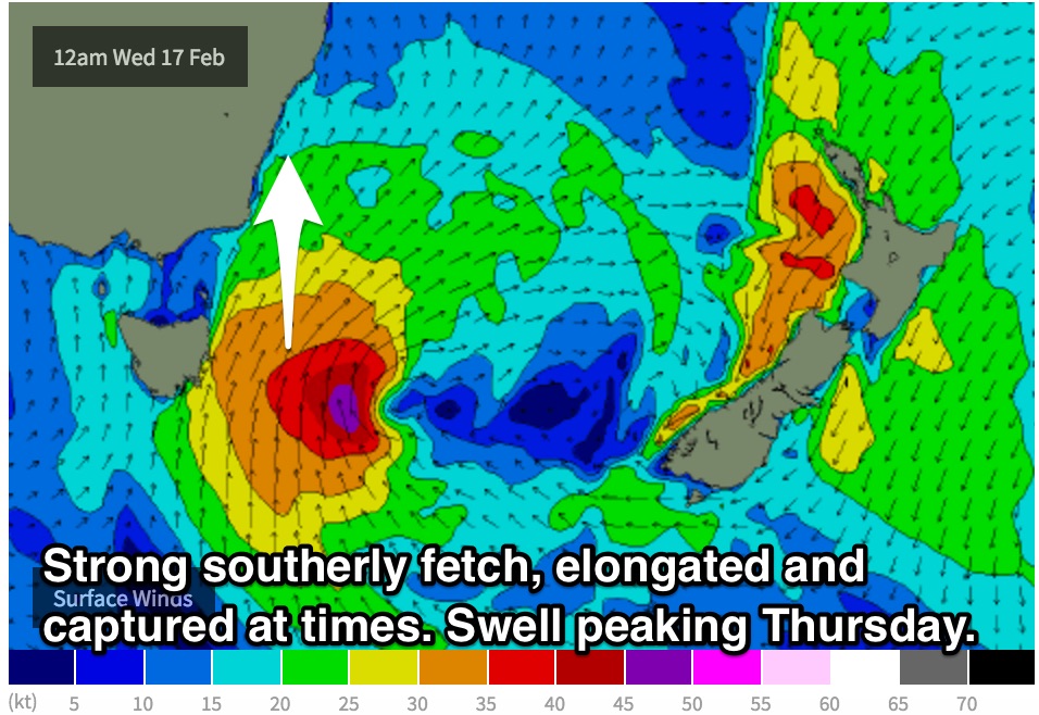
Elongated captured southerly fetches of up to 40-50kts look to be well aligned to the NSW coast and should provide a strong kick in swell.
Initially, gusty southerly local breezes look increase from Tuesday evening and throughout the night, leading to a short range windswell for Wednesday building to around 3-4ft.
Breezes look to favour protected southern corners of the open beaches on Tuesday as a south/southeasterly breeze dominates the coast.
 Again, Wednesday is looking at a southerly component airflow, becoming gusty at times. Those who are keen for a wave before work may score a brief period of south/southwesterly winds, with the best chance of a clean wave at protected southern ends of the open beaches.
The surf looks to build furthermore on Thursday as the effects of the stronger core fetches should fill in, potentially in excess of 6ft across south facing beaches, larger across the Hunter.
Meanwhile, long range east/northeasterly energy from TC Winston should continue to break across open beaches, slowly easing and remaining inconsistent with sets in the 3ft range.
By this stage, breezes look to have eased significantly, with the chance of a light southwesterly breeze in the morning. A light seabreeze looks to move in during the afternoon, but remaining workable.
Comments
Come on s/w for thursday - please align!