Slow start to the week, with swell building late week

Sydney, Hunter and Illawarra Surf Forecast by Guy Dixon (issued Monday 1st February)
Best Days: Southern corners on Saturday. Early Sunday, Monday and Tuesday.
Recap:
The surf slowly eased throughout the weekend, however there were plenty of fun options dotted up and down the coast. In between thunderstorms on Saturday, winds dropped and allowed for periods of clean surf with options in the 3ft range.
Sunday morning offered clean options in the 2-3ft range, with the odd bigger set mixed in further south. Conditions remained clean for a good part of the morning, becoming only slightly unsettled at times in the afternoon.
As for today, a lot of the options have faded, with the surf really only in the 1-2ft range, with the odd 2ft set along the Hunter. Again, seabreezes are light, with periods of slack winds allowing for a loggable wave.
This week (Tuesday 2nd - Friday 5th):
Today’s small conditions are setting the tone well for the next few days, with only small residual energy expected to fill in for the first half of the week.
We aren’t expecting much more than 1ft+ on Tuesday and Wednesday as background southeasterly and easterly energy breaks across the coast.
Dust off your long board and have a look at the open beaches on Tuesday which should be offering clean/workable conditions at the south ends in the morning under a southwesterly airflow. As the morning turns to afternoon, breezes look to swing southeasterly, adding an element of bump into the mix.
Wednesday on the other hand is looking to stay clean for the best part of the day, with light/variable-offshore breezes holding variable into the early afternoon. Breezes then look to swing onshore, eventually increasing from the south later.
The synoptic setup then looks to become much more active, with a complex low expected to develop over the Tasman mid-week.
Wednesday afternoon’s southerlies are expected to continue strengthening overnight and into Thursday, providing us with the first decent size since the weekend.
A short range windswell should build to the 3-4ft+ range across south facing beaches by Thursday afternoon, larger across the Hunter, although severely lacking quality. Southerly breezes have the potential to gust up to 60 km/h, so protected southern corners of the open beaches will be the way to go if quality is what you’re looking for.
Unfortunately, there is likely to be a significant difference in size between protected and exposed spots due to the low periods. The refractive ability of these short range windswells is generally poor, so not much gets into the protected bays/corners.
Friday should see the surf build further to the 3-5ft range across south facing beaches from a mixture of swell sources. Firstly, the gusty southerly breezes are due to continue throughout the day, and despite weakening slightly should still provide plenty of low quality energy.
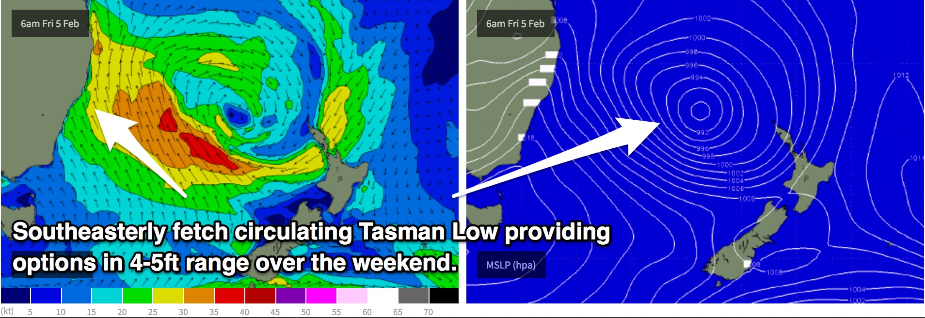
However, a broader fetch along the southern quadrants of this Tasman Low should provide stronger, more dominant southeasterly energy although still lacking quality due to the local breezes.
This weekend (Saturday 6th - Sunday 7th):
As this Tasman low continues to deepen leading into the weekend, models show southeasterly fetches along the southeastern flank of around 30-40kts, providing multiple pulses of southeasterly swell, tending east/southeasterly on Saturday and Sunday.
A second source of southerly swell should also fill in across the south swell magnets in the form of an inconsistent long range groundswell, although modest in size and not overly important due to the prevailing wind direction.
Options should pulse between the 4-5ft range, occasionally bigger, particularly along the Hunter coast.
In addition to this, open beaches should also pick up a healthy sized east/northeasterly swell generated by northeasterly fetches on the eastern flank of the aforementioned low as it develops mid-week. Core fetches of 35-40kts should provide options in the 3-4ft range on Saturday.
You may ask why this fetch in particular isn’t likely to generate as much swell as the southeasterly swell and that’s primarily due to the size/area of the fetch itself. Yes, the winds are just as strong, but the area of ocean which it is impacting is not as broad.
This east/northeasterly energy should come in very handy as a south/southeasterly breeze still looks blowy enough to create pretty ordinary conditions on Saturday, so protected southern corners of the open beaches will be a good place to look.
By Sunday, lighter morning south-west winds will favour southern ends of most beaches.
Next week (Monday 8th onward):
The run of swell looks good for the start of next week also, despite fading a touch.
The surf should ease form the 3-4ft+ range on Monday off the back of the Tasman Low swell, under a light/variable airflow early, tending seabreezey later.
As all these swell generators slow down, a small east/southeasterly fetch over Cook Strait looks to fire up, maintaining around 3-4ft of east/southeasterly swell for the NSW coast on Tuesday.
By this stage, winds should be generally light in the early morning with your typical afternoon seabreezes developing as a high pressure ridge lingers overhead.
Comments
Summer keeps on giving!!!